Cambridge, New Hampshire facts for kids
Quick facts for kids
Cambridge, New Hampshire
|
|
|---|---|

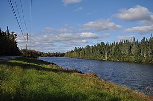
The Androscoggin River along New Hampshire Route 16 in Cambridge
|
|

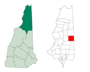
Location in Coös County, New Hampshire
|
|
| Country | United States |
| State | New Hampshire |
| County | Coös |
| Area | |
| • Total | 51.72 sq mi (133.95 km2) |
| • Land | 50.99 sq mi (132.06 km2) |
| • Water | 0.73 sq mi (1.89 km2) 1.41% |
| Elevation | 1,525 ft (465 m) |
| Population
(2020)
|
|
| • Total | 16 |
| • Density | 0.3/sq mi (0.12/km2) |
| Time zone | UTC-5 (Eastern) |
| • Summer (DST) | UTC-4 (Eastern) |
| Area code(s) | 603 |
| FIPS code | 33-007-08420 |
Cambridge is a special kind of area called a township in Coös County, New Hampshire. It's a very small place. In 2020, only 16 people lived there! This was an increase from 8 people in 2010.
In New Hampshire, townships are different from towns. They are parts of a county that aren't officially part of any town. This means they have very little or no local government. Many townships, like Cambridge, are mostly empty. Cambridge is part of the area around Berlin.
Contents
History of Cambridge
Cambridge was first set aside in 1793. It was given to Nathaniel Rogers and others. The area was quite large, about 23,160 acres (9,370 hectares).
Exploring Cambridge's Geography
Most of Cambridge is wild forest. It's a beautiful, natural area.
Lakes and Rivers
The southern part of Umbagog Lake touches Cambridge. You can get to the lake using New Hampshire Route 26. This road comes from nearby Errol or Upton, Maine.
The Androscoggin River starts from Umbagog Lake. It flows south through the northwestern part of Cambridge. A scenic area called the 13-Mile Woods follows this river. New Hampshire Route 16 also runs alongside the river through the township. This road connects north to Errol and south to Berlin.
Land and Water Features
Cambridge covers about 133.9 square kilometers (51.7 square miles). Most of this is land (132.1 sq km or 51.0 sq mi). About 1.9 sq km (0.7 sq mi), or 1.41%, is water.
All of Cambridge is part of the Androscoggin River's water system. This means all the rain and streams in Cambridge eventually flow into the Androscoggin River. Some important streams here include Mollidgewock Brook, Bog Brook, and Chickwolnepy Stream. Chickwolnepy Stream also has a smaller stream called Blackstrap Brook.
The highest point in Cambridge is the top of Cambridge Black Mountain. It stands about 2,780 feet (847 meters) above sea level. To the east, Cambridge shares a border with Oxford County, Maine.
Neighboring Places
Cambridge is surrounded by several other towns and townships:
- Errol (to the north)
- Upton, Maine (to the east)
- North Oxford, Maine (to the east)
- Success (to the southeast)
- Milan (to the south)
- Dummer (to the west)
Population Changes (Demographics)
| Historical population | |||
|---|---|---|---|
| Census | Pop. | %± | |
| 1840 | 5 | — | |
| 1850 | 33 | 560.0% | |
| 1860 | 49 | 48.5% | |
| 1870 | 28 | −42.9% | |
| 1880 | 36 | 28.6% | |
| 1890 | 31 | −13.9% | |
| 1900 | 17 | −45.2% | |
| 1910 | 5 | −70.6% | |
| 1920 | 1 | −80.0% | |
| 1930 | 1 | 0.0% | |
| 1940 | 0 | −100.0% | |
| 1950 | 8 | — | |
| 1960 | 0 | −100.0% | |
| 1970 | 4 | — | |
| 1980 | 5 | 25.0% | |
| 1990 | 0 | −100.0% | |
| 2000 | 10 | — | |
| 2010 | 8 | −20.0% | |
| 2020 | 16 | 100.0% | |
| U.S. Decennial Census | |||
Demographics is the study of populations. It looks at how many people live somewhere and what they are like.
In 2000, there were 10 people living in Cambridge. These people made up 5 households, with 3 of them being families. The population was very spread out, with only about 0.2 people per square mile.
The population has changed a lot over the years, sometimes going up and sometimes down. In 1940 and 1990, no one was officially counted as living there! But by 2020, the population had grown to 16 people.
See also
In Spanish: Cambridge (Nuevo Hampshire) para niños

