
Camden, New York facts for kids
Quick facts for kids
Camden
|
|
|---|---|
_highlighted.svg)
Location in Oneida County and the state of New York.
|
|
.svg)
Location of New York in the United States
|
|
| Country | United States |
| State | New York |
| County | Oneida |
| Area | |
| • Total | 54.15 sq mi (140.26 km2) |
| • Land | 54.01 sq mi (139.89 km2) |
| • Water | 0.14 sq mi (0.36 km2) |
| Population
(2010)
|
|
| • Total | 4,934 |
| • Estimate
(2016)
|
4,887 |
| • Density | 90.48/sq mi (34.93/km2) |
| Time zone | UTC-5 (EST) |
| • Summer (DST) | UTC-4 (EDT) |
| Zip Code |
13316
|
| Area Code | 315 |
| FIPS code | 36-065-11858 |
Camden is a town in Oneida County, New York, United States. In 2010, about 4,934 people lived there.
The town of Camden also has a smaller area called the Village of Camden. The town is in the northwest part of Oneida County. It is also northwest of the City of Rome.
Contents
History
People first started settling in Camden around 1792. The town was officially formed in 1799 from the Town of Mexico.
Camden is home to International Wire, which is the biggest employer in the town. For a long time, Camden only had one stop light! A second one was added in 1999. In 1800, the population of Camden was 354 people.
Geography
The town of Camden covers about 54.1 square miles (140.26 square kilometers). Most of this area is land, with only a small part being water.
Camden is located north-northwest of Oneida Lake. The western edge of the town is the border with Oswego County.
Climate
Camden has a climate known as a "warm-summer humid continental climate." This means it has warm summers and cold, snowy winters.
The hottest temperature ever recorded in Camden was 98°F (37°C) on August 30, 2022. The coldest temperature ever recorded was a very chilly -41°F (-41°C) on February 11, 1979.
| Climate data for Camden, New York, 1991–2020 normals, extremes 1960–present | |||||||||||||
|---|---|---|---|---|---|---|---|---|---|---|---|---|---|
| Month | Jan | Feb | Mar | Apr | May | Jun | Jul | Aug | Sep | Oct | Nov | Dec | Year |
| Record high °F (°C) | 64 (18) |
69 (21) |
82 (28) |
89 (32) |
93 (34) |
94 (34) |
96 (36) |
98 (37) |
92 (33) |
85 (29) |
77 (25) |
69 (21) |
98 (37) |
| Mean maximum °F (°C) | 51.9 (11.1) |
51.0 (10.6) |
62.1 (16.7) |
79.6 (26.4) |
85.2 (29.6) |
88.5 (31.4) |
89.9 (32.2) |
88.8 (31.6) |
86.6 (30.3) |
78.1 (25.6) |
67.0 (19.4) |
53.0 (11.7) |
91.5 (33.1) |
| Mean daily maximum °F (°C) | 28.6 (−1.9) |
30.5 (−0.8) |
39.4 (4.1) |
53.7 (12.1) |
67.4 (19.7) |
75.5 (24.2) |
80.6 (27.0) |
79.1 (26.2) |
72.5 (22.5) |
59.4 (15.2) |
46.3 (7.9) |
34.6 (1.4) |
55.6 (13.1) |
| Daily mean °F (°C) | 19.8 (−6.8) |
20.9 (−6.2) |
29.6 (−1.3) |
42.9 (6.1) |
55.1 (12.8) |
63.8 (17.7) |
68.4 (20.2) |
67.2 (19.6) |
60.2 (15.7) |
48.7 (9.3) |
37.5 (3.1) |
27.0 (−2.8) |
45.1 (7.3) |
| Mean daily minimum °F (°C) | 11.0 (−11.7) |
11.2 (−11.6) |
19.8 (−6.8) |
32.1 (0.1) |
42.8 (6.0) |
52.0 (11.1) |
56.2 (13.4) |
55.2 (12.9) |
47.8 (8.8) |
38.1 (3.4) |
28.7 (−1.8) |
19.4 (−7.0) |
34.5 (1.4) |
| Mean minimum °F (°C) | −14.0 (−25.6) |
−11.4 (−24.1) |
−2.0 (−18.9) |
19.3 (−7.1) |
28.3 (−2.1) |
38.3 (3.5) |
44.9 (7.2) |
44.1 (6.7) |
33.9 (1.1) |
25.2 (−3.8) |
14.3 (−9.8) |
−1.3 (−18.5) |
−18.5 (−28.1) |
| Record low °F (°C) | −38 (−39) |
−41 (−41) |
−32 (−36) |
0 (−18) |
19 (−7) |
27 (−3) |
30 (−1) |
32 (0) |
24 (−4) |
13 (−11) |
−9 (−23) |
−27 (−33) |
−41 (−41) |
| Average precipitation inches (mm) | 3.86 (98) |
3.35 (85) |
3.34 (85) |
4.09 (104) |
4.32 (110) |
4.41 (112) |
4.49 (114) |
4.02 (102) |
4.28 (109) |
5.07 (129) |
4.44 (113) |
4.26 (108) |
49.93 (1,269) |
| Average snowfall inches (cm) | 41.4 (105) |
38.0 (97) |
17.1 (43) |
2.9 (7.4) |
0.0 (0.0) |
0.0 (0.0) |
0.0 (0.0) |
0.0 (0.0) |
0.0 (0.0) |
1.1 (2.8) |
15.6 (40) |
35.2 (89) |
151.3 (384.2) |
| Average precipitation days (≥ 0.01 in) | 17.5 | 14.5 | 13.8 | 13.7 | 13.5 | 12.0 | 11.8 | 11.5 | 10.8 | 15.6 | 14.2 | 18.0 | 166.9 |
| Average snowy days (≥ 0.1 in) | 14.4 | 12.2 | 7.7 | 2.1 | 0.1 | 0.0 | 0.0 | 0.0 | 0.0 | 0.3 | 3.6 | 11.4 | 51.8 |
| Source 1: NOAA | |||||||||||||
| Source 2: National Weather Service | |||||||||||||
Population Information
| Historical population | |||
|---|---|---|---|
| Census | Pop. | %± | |
| 1800 | 384 | — | |
| 1810 | 1,132 | 194.8% | |
| 1820 | 1,772 | 56.5% | |
| 1830 | 1,945 | 9.8% | |
| 1840 | 2,331 | 19.8% | |
| 1850 | 2,820 | 21.0% | |
| 1860 | 3,187 | 13.0% | |
| 1870 | 3,637 | 14.1% | |
| 1880 | 3,392 | −6.7% | |
| 1890 | 3,391 | 0.0% | |
| 1900 | 3,745 | 10.4% | |
| 1910 | 3,426 | −8.5% | |
| 1920 | 3,054 | −10.9% | |
| 1930 | 2,977 | −2.5% | |
| 1940 | 3,096 | 4.0% | |
| 1950 | 3,655 | 18.1% | |
| 1960 | 4,318 | 18.1% | |
| 1970 | 4,942 | 14.5% | |
| 1980 | 4,925 | −0.3% | |
| 1990 | 5,134 | 4.2% | |
| 2000 | 5,018 | −2.3% | |
| 2010 | 4,934 | −1.7% | |
| 2016 (est.) | 4,887 | −1.0% | |
| U.S. Decennial Census | |||
In 2000, there were 5,028 people living in Camden. There were 1,881 households, and 1,346 of these were families. The population density was about 93 people per square mile.
About 35% of households had children under 18 living with them. The average household had 2.63 people. The average family had 3.09 people.
The median age in the town was 37 years old. About 27% of the population was under 18.
Education
Camden is part of the Camden Central School District. This school district is the second largest in New York state by area. It covers not only the town of Camden but also parts of other towns. These include Annsville, Florence, Lee, and Vienna in Oneida County. It also reaches into Lewis and Oswego counties.
Younger students in the district go to one of two elementary schools:
- Camden Elementary (in the village of Camden)
- McConnellsville Elementary (in the town of Vienna)
After elementary school, all students go to the middle school and then to Camden High School.
Forest Park
Forest Park is a popular spot in Camden. It is located off Route 13. The park has a 1.75-mile loop for walking, jogging, and biking. Two brooks, Emmons Brook and Cob Brook, flow through the park. In winter, the park is closed to everyone except skiers because the paths are covered in snow. Forest Park also has an apartment building and a cemetery.
History
Forest Park used to be owned by Mr. Alva Raymond, and it was named after him. Before Raymond, the land belonged to the Ransom Estate and even earlier, to Mr. Daniel Parke. Both were important people in Camden's early days.
The first part of the park, 62 acres, was bought in 1891. Another 40 acres were added in 1897. The total cost for these purchases was $2,400. Today, the park is much larger, with 117 acres, and it has many more picnic areas.
Attractions
Many Camden residents visit Forest Park in the spring and summer. It's a great place for outdoor activities. People enjoy walking, jogging, and biking on its paved roads.
The park is also a favorite spot for summer picnics and family reunions. Many photographers like to take pictures there. Graduation parties and church events are often held at the park's pavilions.
Forest Park Cemetery
Forest Park Cemetery is located about half a mile south of Camden. It is across from Oneida Savings Bank. Mrs. Clarissa Ranson and her husband bought the first burial plot in 1840. Records of all burials have been kept since 1845. In 1876, many bodies were moved here from older cemeteries.
Communities and Locations in the Town of Camden
- Camden – This is the main village within the town. It's where NY 13 and NY 69 meet.
- Hillsboro – A small community (hamlet) located west of Camden village.
- Preston Hill – A place found south of Camden village.
- Westdale – Another small community (hamlet) in the northwestern part of the town.
Notable People
- Todd Gordon – A former NASCAR crew chief and radio announcer.
- Lynn Lovenguth – A baseball player.
Images for kids
-
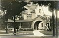
Frisbie House in Camden around 1915
-
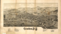
A map of Camden from 1885 showing important places, by L.R. Burleigh
-
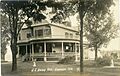
54 Union Street in Camden around 1915


See also
 In Spanish: Camden (Nueva York) para niños
