
Camelback Mountain facts for kids
Quick facts for kids Camelback Mountain |
|
|---|---|
 |
|
| Highest point | |
| Elevation | 2,706 ft (825 m) NAVD 88 |
| Prominence | 1,334 ft (407 m) |
| Geography | |

Camelback Mountain
Location in Arizona
|
|
| Location | Maricopa County, Arizona, U.S. |
| Parent range | Phoenix Mountains |
| Topo map | USGS Paradise Valley |
| Geology | |
| Mountain type | granite, sandstone |
| Climbing | |
| Easiest route | Echo Canyon trail, Cholla trail |
Camelback Mountain (called Cew S-wegiom by some Native American groups) is a famous mountain in Phoenix, Arizona, United States. It gets its English name because it looks like a kneeling camel with a hump and a head. This mountain is a well-known landmark in the Phoenix metropolitan area. You can find it between the Arcadia neighborhood of Phoenix and the town of Paradise Valley. It's a popular spot for people who love to hike and rock climb.
Contents
Mountain History: Protecting a Landmark
Ancient Uses of Camelback Mountain
Long ago, a cave was found on the north side of Camelback Mountain. This cave shows that the mountain was a special, sacred place for the ancient Hohokam people. They lived in this area before they left in the 14th century.
Early Efforts to Protect the Land
In January 1879, the President of the United States, Rutherford B. Hayes, set aside a huge area of land. This land, which included Camelback Mountain, was meant to be a reservation for the Pima and Maricopa tribes. However, just six months later, the Arizona government changed this decision. They wanted to make sure that the non-Native American residents could keep their land and access to water from the Salt River.
Saving Camelback Mountain from Development
People started trying to protect Camelback Mountain as a natural area in the early 1900s. But by the 1960s, most of the land had been sold to private owners. Government officials tried to stop building on the higher parts of the mountain. These efforts didn't work at first, and a plan to trade land failed in 1963.
Then, in 1965, United States Senator Barry Goldwater stepped in to help. He played a big part in making sure the higher areas of the mountain were saved from being built on. Finally, in 1968, Camelback Mountain became a city park for Phoenix.
Camelback Road and Its Name
The mountain also gave its name to a major road in the Phoenix area. This road is called Camelback Road. It stretches for about 34 miles (55 km) from Scottsdale, going west past towns like Goodyear and Litchfield Park.
Camelback Mountain is recognized as a Phoenix Point of Pride. This means it's one of the important and special places in the city.
Mountain Makeup: What Camelback is Made Of
Camelback Mountain is made of two different types of rock. It's like two separate layers joined together.
- The higher part of the mountain is made of very old granite. This granite is about 1.5 billion years old!
- The "head" part of the camel is mostly made of red sandstone. This sandstone is much younger, about 25 million years old.
Fun Activities: Hiking and Climbing
Camelback Mountain is a fantastic place for outdoor activities.
Hiking Trails to the Top
There are two main hiking trails that go up to the peak of Camelback Mountain. They climb about 1,280 feet (390 meters) in elevation.
- The Echo Canyon Trail is about 1.14 miles (1,900 meters) long.
- The Cholla Trail is about 1.4 miles (2,300 meters) long.
Both trails are considered challenging because they are very steep. The paths have dirt, gravel, and large rocks. Some parts even have handrails to help you climb. Most people take about 1.5 to 3 hours to hike up and down the mountain.
The Praying Monk: A Climbing Challenge
On the northern side of the mountain, there's a unique rock formation called the Praying Monk. It's made of red sandstone and looks like a person kneeling in prayer. This rock formation is about 100 feet (30 meters) tall. The eastern side of the Praying Monk has special bolts for rock climbers to attach their ropes safely.
Gallery
-
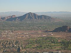
Aerial view of the mountain
-
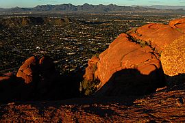
A view along one of the hiking trails
-
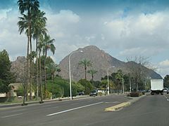
Camelback Mountain as seen from Camelback Road


