Campvale, New South Wales facts for kids
Quick facts for kids CampvaleNew South Wales |
|||||||||||||||
|---|---|---|---|---|---|---|---|---|---|---|---|---|---|---|---|

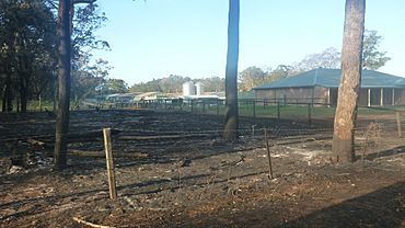
Rural properties at Campvale after the 2013 New South Wales bushfires
|
|||||||||||||||

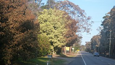
Richardson Road, the main road through Campvale after the 2013 New South Wales bushfires
|
|||||||||||||||
| Postcode(s) | 2318 | ||||||||||||||
| Elevation | 5 m (16 ft) | ||||||||||||||
| Area | 15.8 km2 (6.1 sq mi) | ||||||||||||||
| Time zone | AEST (UTC+10) | ||||||||||||||
| • Summer (DST) | AEDT (UTC+11) | ||||||||||||||
| Location |
|
||||||||||||||
| LGA(s) | Port Stephens Council | ||||||||||||||
| Region | Hunter | ||||||||||||||
| County | Gloucester | ||||||||||||||
| Parish | Stowell | ||||||||||||||
| State electorate(s) | Port Stephens | ||||||||||||||
| Federal Division(s) | Paterson | ||||||||||||||
|
|||||||||||||||
Campvale is a quiet, mostly rural area in New South Wales, Australia. It's part of the Port Stephens Council region, which is a type of local government area. You can find Campvale in the Hunter Region.
Exploring Campvale's Location
Campvale is shaped like a rectangle. It's mostly made up of bushland with sandy soil.
Main Roads in Campvale
The main road that cuts through Campvale is called Richardson Road. This road goes from east to west, connecting Raymond Terrace to Port Stephens.
Another important road is Medowie Road. It crosses Richardson Road at a place called the Medowie roundabout. Medowie Road goes from south to north, linking places like Williamtown, Campvale, Medowie, and Ferodale to the Pacific Highway.
There's also a smaller road in the northeastern part of Campvale. It runs along Grahamstown Dam, letting people get from Richardson Road to Medowie.
Where People Live
Most of Campvale is bushland. Only a small number of homes are located north of Richardson Road. This area is found between Grahamstown Dam and the Medowie Roundabout. This is the only part of Campvale where people live. In 2011, about 41 people lived here. The average age of residents was 50 years old.
 | Tommie Smith |
 | Simone Manuel |
 | Shani Davis |
 | Simone Biles |
 | Alice Coachman |


