Canisteo, New York facts for kids
Quick facts for kids
Canisteo
|
|
|---|---|
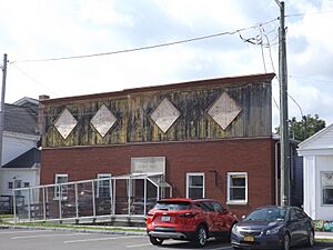
Town hall
|
|
| Country | United States |
| State | New York |
| County | Steuben |
| Area | |
| • Total | 54.36 sq mi (140.79 km2) |
| • Land | 54.35 sq mi (140.77 km2) |
| • Water | 0.01 sq mi (0.02 km2) |
| Population
(2020)
|
|
| • Total | 3,294 |
| • Estimate
(2021)
|
3,260 |
| • Density | 60.13/sq mi (23.22/km2) |
| Time zone | UTC-5 (Eastern (EST)) |
| • Summer (DST) | UTC-4 (EDT) |
| FIPS code | 36-101-12265 |
Canisteo is a town in Steuben County, New York, United States. In 2020, about 3,294 people lived here. The name comes from a Native American village that used to be in the area. It is an Iroquoian word.
The Town of Canisteo is located in the western part of Steuben County. It is southeast of the city of Hornell. Inside the town, there is also a village called Canisteo.
Contents
What Does "Canisteo" Mean?
The name "Canisteo" comes from the Seneca language. It means something like "board on the water."
Canisteo's Early History
The Seneca people had a large village here called "Kah-nis-ti-oh." This area has many interesting Native American stories.
The first European settlers arrived around 1788. This makes Canisteo one of the oldest settled places in Steuben County. Many early settlers came from Pennsylvania. They traveled mainly by the Susquehanna River, as there were no direct roads to Albany or New York City.
The town was officially formed in 1796. It was one of the first towns created when the county was established. Early records show Canisteo was a large area. The Canisteo River flowed through it. Boats could travel on the river, carrying goods like wheat. Products were shipped to the port of Baltimore using the Canisteo, Chemung, and Susquehanna Rivers.
Hornell was once a village within the town of Canisteo. Over time, parts of Canisteo were used to form other towns. These include West Union, Hartsville, Hornellsville (in 1820), Troupsburg (in 1808 and 1818), Greenwood (in 1827), and Jasper (in 1837).
In 1905, the population of Canisteo was 3,171 people. Some residents from Canisteo later moved and settled Canisteo Township, Dodge County, Minnesota.
The Canisteo Living Sign
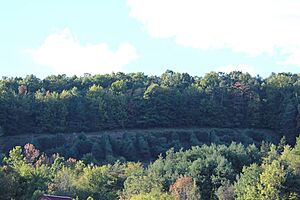
The Canisteo Living Sign is known as the largest living sign in the world. It has been recognized by both Ripley's Believe it or Not! and the Registry of Historical Places. The sign is about 60 feet (18 meters) tall and 400 feet (122 meters) wide. It is made up of Scotch pine trees. The seeds for this unique sign were planted in 1934.
Business and Industry in Canisteo
In the early days, the main activities in Canisteo were farming and cutting timber. The Canisteo River was important for moving products.
After the Erie Railroad arrived in 1851, the Village of Canisteo became home to many small factories.
More recently, Canisteo has become a center for the Canisteo Wind Farm. This farm uses wind turbines to create electricity for the area.
Schools in Canisteo
All of the schools in the Town of Canisteo are located in the village of Canisteo.
Early One-Room Schools
Canisteo's very first school was a one-room building. It was located on Greenwood Street. A dedicated schoolhouse was built in 1826. Over time, many one-room schools were built around the township.
Canisteo Graded School
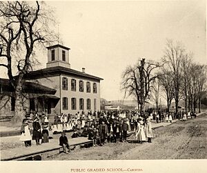
The oldest school building was at 22 Fifth Street. It was a wooden building known as Canisteo Graded School or Canisteo Union School. It started as an elementary school. In the late 1800s, it had five female teachers and a male principal. Each teacher usually taught two grades in one classroom.
By 1900, the school cost about $7,947 to run for a year. A part of this money was raised through taxes. This building was used until 1914. After that, it became a mill and then a feed store. It was torn down around 1952. The land later became the Rotary Field, used for school sports.
Canisteo Academy: A High School for the Area
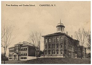
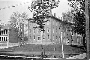
Canisteo Academy was the second high school in Steuben County. It officially started in 1868. A brick building for the academy opened in 1871 on Greenwood Street. At that time, there were no similar high schools in nearby towns like Hornell or Corning. The closest academies were many miles away.
The academy was founded by Rev. Lewis F. Laine. It had a special observatory with a large, rotating telescope. This was the only one of its kind in the county. The New York and Pennsylvania Railroad even had a stop near the academy for students and teachers. Students came from far away, some staying in boarding houses during the week.
Students paid tuition until 1897, when it became a free public school. In 1874, tuition was $10 per term. The academy offered many subjects. These included Latin, Greek, German, French, English, math, and science. Teachers' Institutes, which were training sessions for teachers, were also held at the academy.
Modern Schools in Canisteo
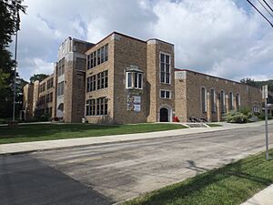
An elementary school was built in 1914 next to the academy. In 1937, the academy building was taken down. A new school, Canisteo Central School, was built. This new school is now the Canisteo–Greenwood High School. More additions were built in 1949, including a cafeteria and music rooms.
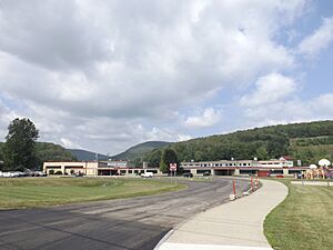
In 1959, a new elementary school was built further south. It included a swimming pool. Today, this building houses both the elementary and a middle school. In 2004, the Canisteo schools joined with Greenwood schools. They formed the Canisteo-Greenwood School District.
As of 2017, Canisteo-Greenwood is the only school in Steuben County that has both an orchestra and a band.
Canisteo's Geography
The town of Canisteo covers about 54.4 square miles (140.8 square kilometers) of land.
The Canisteo River flows from west to east through the northern part of the town.
New York State Route 248 starts at New York State Route 36 in Canisteo village.
Canisteo's Population
| Historical population | |||
|---|---|---|---|
| Census | Pop. | %± | |
| 1820 | 891 | — | |
| 1830 | 620 | −30.4% | |
| 1840 | 941 | 51.8% | |
| 1850 | 2,030 | 115.7% | |
| 1860 | 2,337 | 15.1% | |
| 1870 | 2,435 | 4.2% | |
| 1880 | 3,604 | 48.0% | |
| 1890 | 3,629 | 0.7% | |
| 1900 | 3,432 | −5.4% | |
| 1910 | 3,441 | 0.3% | |
| 1920 | 2,901 | −15.7% | |
| 1930 | 3,391 | 16.9% | |
| 1940 | 3,381 | −0.3% | |
| 1950 | 3,568 | 5.5% | |
| 1960 | 3,652 | 2.4% | |
| 1970 | 3,777 | 3.4% | |
| 1980 | 3,991 | 5.7% | |
| 1990 | 3,636 | −8.9% | |
| 2000 | 3,583 | −1.5% | |
| 2010 | 3,391 | −5.4% | |
| 2020 | 3,294 | −2.9% | |
| 2021 (est.) | 3,260 | −3.9% | |
| U.S. Decennial Census | |||
In 2000, there were 3,583 people living in the town. Most people were White (98.24%). About 30.6% of households had children under 18. The average household had 2.52 people. The median age in the town was 39 years old.
Places in the Town of Canisteo
Here are some of the communities and locations found in the Town of Canisteo:
- Adrian – A small community in the northeast, by the Canisteo River.
- Bennetts – A community south of the village, along NY-248 and Bennetts Creek.
- Bennetts Creek – A stream that flows north and joins the Canisteo River near Canisteo village.
- Browns Crossing – A community near the eastern town line, by the Canisteo River.
- Canisteo – The main village, located where Routes 36 and 248 meet.
- Canisteo Center – A community east of Canisteo village. This was the original village area.
- Carson – Another name for Canisteo Center.
- Dead Man's Hole – A swimming spot on Bennetts Creek, south of Canisteo village.
- Fall Creek – A community south of the village, on NY-248 and Bennetts Creek.
- Gravel Run – A community north of South Canisteo on NY-36.
- Purdy Creek – A stream that flows east and joins Bennett's Creek near Canisteo village.
- Rock Run – A location north of South Canisteo.
- South Canisteo – A community southeast of Canisteo village on NY-36.
See also
 In Spanish: Canisteo para niños
 | Janet Taylor Pickett |
 | Synthia Saint James |
 | Howardena Pindell |
 | Faith Ringgold |


