
Canunda, South Australia facts for kids
Quick facts for kids CanundaSouth Australia |
|||||||||||||||
|---|---|---|---|---|---|---|---|---|---|---|---|---|---|---|---|

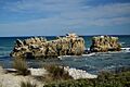
Mounce and Battye Rocks, Canunda
|
|||||||||||||||

Canunda
Location in South Australia
|
|||||||||||||||
| Established | 23 February 1995 | ||||||||||||||
| Postcode(s) | 5291 | ||||||||||||||
| Time zone | ACST (UTC+9:30) | ||||||||||||||
| • Summer (DST) | ACST (UTC+10:30) | ||||||||||||||
| Location |
|
||||||||||||||
| LGA(s) | District Council of Grant Wattle Range Council |
||||||||||||||
| Region | Limestone Coast | ||||||||||||||
| County | Grey | ||||||||||||||
| State electorate(s) | MacKillop Mount Gambier |
||||||||||||||
| Federal Division(s) | Barker | ||||||||||||||
|
|||||||||||||||
|
|||||||||||||||
| Footnotes | Locations Adjoining localities |
||||||||||||||
Canunda is a coastal area in the state of South Australia. It is located on the south-east coast. This area looks out over the Southern Ocean, which is also known as the Great Australian Bight by some international groups.
Canunda is about 339 kilometers (210 miles) south-east of Adelaide, the capital city of South Australia. It is also about 49 kilometers (30 miles) south of Mount Gambier.
What is Canunda?
Canunda was officially named in February 1995. Its name comes from the nearby "Canunda Conservation Park."
Where is Canunda Located?
Canunda covers a long stretch of coastline. It starts south of Southend in the north. It reaches almost to Cape Banks in the south. The area also includes the land between the coast and the Woakwine Range to the east. The entire Lake Bonney SE is also part of Canunda.
What is the Land Used For?
The land in Canunda is used for two main purposes:
- Farming: Some areas are used for agriculture, like growing crops or raising animals.
- Protecting Nature: A lot of the land along the coast is set aside for conservation. This means it is protected to keep its natural environment safe. This protected area is known as the Canunda National Park.
Historical Sites in Canunda
There are important historical places here too. The old Lake Bonney Woolwash and Fellmongery Sites are located right on the border between Canunda and the nearby area of Millicent. These sites show how wool was once processed in the region.
How Canunda is Governed
Canunda is part of several government areas. These areas help manage and make decisions for the region.
- Federal Government: It is in the federal division of Barker. This is a large area represented by a member of the Australian Parliament.
- State Government: For state elections, Canunda is split between the MacKillop and Mount Gambier districts. These districts elect members to the South Australian Parliament.
- Local Government: At a local level, Canunda is managed by two councils: the District Council of Grant and the Wattle Range Council. These councils handle local services like roads and waste.
Images for kids
-
Mounce and Battye Rocks, Canunda
