
Capitol Dome (Utah) facts for kids
Quick facts for kids Capitol Dome |
|
|---|---|

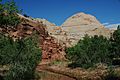
West aspect, from State Route 24
|
|
| Highest point | |
| Elevation | 6,120 ft (1,870 m) |
| Prominence | 320 ft (98 m) |
| Isolation | 0.54 mi (0.87 km) |
| Parent peak | Navajo Dome (6,485 ft) |
| Geography | |

Capitol Dome
Location in Utah

Capitol Dome
Location in the United States
|
|
| Location | Capitol Reef National Park Wayne County, Utah, United States |
| Parent range | Colorado Plateau |
| Topo map | USGS Fruita |
| Geology | |
| Age of rock | Jurassic |
| Type of rock | Navajo Sandstone |
| Climbing | |
| Easiest route | class 5.x climbing |
Capitol Dome is a tall, dome-shaped mountain in Capitol Reef National Park in Utah, USA. It stands about 6,120 feet (1,865 meters) high.
This amazing landmark is found about 2.5 miles (4 km) east of the park's main visitor center. It's also not far from another peak called Navajo Dome. Rain and snow that fall on Capitol Dome flow into small streams. These streams eventually reach the Fremont River, which then joins the mighty Colorado River.
Capitol Dome towers about 800 feet (244 meters) above the Fremont River and a nearby road, State Route 24. Its rounded, dome-like top reminded early explorers and settlers of the domes on government buildings. This is how Capitol Reef National Park got its name!
What is Capitol Dome Made Of?
Capitol Dome is made of a type of rock called Navajo Sandstone. Scientists believe this sandstone formed about 180 million years ago. Back then, this area was a giant sand sea, the biggest one Earth has ever seen!
In a hot, dry climate, strong winds blew sand dunes around. This created huge, sweeping patterns in the sand called crossbeds. These patterns are still visible in the rock today and tell us about the Jurassic period when the sand was laid down.
Millions of years later, the entire Colorado Plateau slowly lifted up. This usually keeps rock layers flat. However, Capitol Reef is special because of the Waterpocket Fold. This is a huge bend in the rock layers, like a giant wrinkle in the Earth's crust. It formed between 50 and 70 million years ago during a time of big mountain building called the Laramide Orogeny.
Exploring Capitol Dome
Capitol Dome is a popular spot for climbing and hiking. The easiest way to climb it is rated as a 5.x on the Yosemite Decimal System, which means it's a challenging climb. Many visitors enjoy views of Capitol Dome from nearby trails, like the Hickman Bridge Trail.
Weather at Capitol Reef
The best times to visit Capitol Dome are in the spring and fall. The area has a Cold semi-arid climate. This means winters can be cold, with average temperatures below 32°F (0°C). Most of the rain and snow falls in spring and summer.
Capitol Reef is a desert climate. It usually gets less than 10 inches (254 mm) of rain each year. Snowfall in winter is usually light.
| Climate data for Capitol Reef Visitor Center, elevation 5,653 ft (1,723 m), 1981-2010 normals, extremes 1981-2019 | |||||||||||||
|---|---|---|---|---|---|---|---|---|---|---|---|---|---|
| Month | Jan | Feb | Mar | Apr | May | Jun | Jul | Aug | Sep | Oct | Nov | Dec | Year |
| Record high °F (°C) | 58.6 (14.8) |
68.3 (20.2) |
78.3 (25.7) |
84.4 (29.1) |
94.6 (34.8) |
100.2 (37.9) |
100.8 (38.2) |
97.9 (36.6) |
95.4 (35.2) |
86.1 (30.1) |
70.4 (21.3) |
61.5 (16.4) |
100.8 (38.2) |
| Mean daily maximum °F (°C) | 40.6 (4.8) |
46.4 (8.0) |
54.7 (12.6) |
65.0 (18.3) |
74.5 (23.6) |
85.3 (29.6) |
90.4 (32.4) |
87.9 (31.1) |
80.2 (26.8) |
66.1 (18.9) |
51.3 (10.7) |
40.6 (4.8) |
65.3 (18.5) |
| Mean daily minimum °F (°C) | 17.8 (−7.9) |
22.7 (−5.2) |
30.2 (−1.0) |
36.2 (2.3) |
44.7 (7.1) |
53.1 (11.7) |
60.4 (15.8) |
58.5 (14.7) |
50.4 (10.2) |
39.0 (3.9) |
27.6 (−2.4) |
18.2 (−7.7) |
38.3 (3.5) |
| Record low °F (°C) | −4.2 (−20.1) |
−11.8 (−24.3) |
9.1 (−12.7) |
18.1 (−7.7) |
27.2 (−2.7) |
34.6 (1.4) |
42.4 (5.8) |
45.1 (7.3) |
29.9 (−1.2) |
11.7 (−11.3) |
8.0 (−13.3) |
−7.5 (−21.9) |
−11.8 (−24.3) |
| Average precipitation inches (mm) | 0.52 (13) |
0.34 (8.6) |
0.53 (13) |
0.47 (12) |
0.59 (15) |
0.47 (12) |
0.91 (23) |
1.20 (30) |
0.80 (20) |
0.98 (25) |
0.49 (12) |
0.32 (8.1) |
7.62 (194) |
| Average dew point °F (°C) | 17.3 (−8.2) |
20.8 (−6.2) |
23.0 (−5.0) |
24.5 (−4.2) |
29.1 (−1.6) |
32.0 (0.0) |
40.0 (4.4) |
41.8 (5.4) |
34.8 (1.6) |
28.2 (−2.1) |
21.9 (−5.6) |
17.5 (−8.1) |
27.6 (−2.4) |
| Source: PRISM | |||||||||||||
Gallery
-
Capitol Dome, west side, with the Fremont River
-
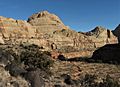
Capitol Dome seen from the Hickman Bridge Trail
-
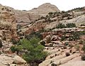
Another view of Capitol Dome from the Hickman Bridge Trail
-
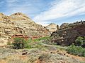
Capitol Dome (on the left) and Highway 24
.jpg)


