
Car navigation facts for kids

Car navigation helps drivers know exactly where they are on a map. It also shows them how to get to where they want to go. Most car navigation systems use something called GPS. This system uses radio signals from special satellites orbiting Earth. These satellites send out signals with their location and the exact time.
A GPS receiver in your car catches these signals. It figures out how long the signal took to reach it. Since the speed of radio signals is known, the receiver can then calculate its distance from each satellite. This is how your car's navigation system knows your position.
Contents
Imagine you are driving your car with a GPS receiver. The receiver might pick up a signal from a satellite above Dover in the south. It also gets a signal from another satellite above Perth in the north. Your GPS receiver now knows exactly how far it is from Dover and how far it is from Perth.
With information from just two satellites, there are two possible places your car could be on a flat map. To figure out the correct spot, the GPS needs a third satellite. Let's say this third satellite is above Land's End in the west. With three satellites, the GPS can pinpoint your exact location. It can even tell you how high up you are.
But there's one more thing the GPS receiver needs: a fourth satellite. This is because the receiver needs to know the time very, very precisely. The fourth satellite helps the GPS receiver get the exact time. This allows it to calculate distances and your position even more accurately.
What Your GPS Receiver Does

Your GPS receiver is like a smart helper in your car. It constantly looks for the strongest satellite signals. Then, it quickly calculates your exact position and the direction you are heading. All this information is shown on a small screen, usually as a three-dimensional map.
The screen also shows your driving speed. It can tell you how far it is to the next turn or exit. You can type in the address where you want to go. The GPS receiver will then guide you step-by-step. It often uses clear voice directions to tell you when to turn.
Some GPS systems can even show you where there are traffic jams. They can warn you about speed cameras or traffic lights. The system can even suggest a different route to help you avoid these things. This can save you time and make your trip smoother. If you accidentally go off the planned route, don't worry! The GPS receiver will quickly recalculate and give you new directions to your destination.
Maps Inside Your GPS
To show you where you are, GPS receivers have digital maps stored inside them. These maps are like very detailed digital versions of paper maps. Many GPS devices let you add new maps or update your current ones. This means you can always have the latest road information for better navigation.
GPS on Mobile Phones
Many mobile phones today have GPS receivers built into them. However, most of these phones need an Internet connection to use their maps. This is because they download map information as you go. Some apps, like Nokia's HERE Maps, let you download and store maps on your phone. This means you can use your phone as a GPS even when you don't have an internet connection.
Images for kids
-
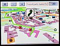
Navigation with Gosmore, an open source routing software, using free map data from OpenStreetMap.
-
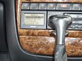
A GPS system designed by Philips in a 1995 Opel Omega car.


See also
 In Spanish: Sistema de navegación para automóviles para niños
