
Caral facts for kids

Remains of Caral
|
|

Location in Peru

Location in South America
|
|
| Alternative name | Caral-Supe |
|---|---|
| Location | Lima Region, Peru |
| Coordinates | 10°53′37″S 77°31′13″W / 10.89361°S 77.52028°W |
| Type | Settlement |
| History | |
| Founded | c. 2600 BC |
| Abandoned | c. 2000 BC |
| Cultures | Norte Chico |
| Site notes | |
| Condition | In ruins |
| UNESCO World Heritage Site | |
| Official name | Sacred City of Caral-Supe |
| Location | Supe District, Barranca Province, Peru |
| Criteria | Cultural: (ii), (iii), (iv) |
| Inscription | 2009 (33rd Session) |
| Area | 626.36 ha (2.4184 sq mi) |
| Buffer zone | 14,620.31 ha (56.4493 sq mi) |
Caral is an amazing archaeological site in Peru. It's where the remains of the main city of the ancient Caral civilization were found. This incredible city is located in the Supe valley, about 182 kilometers north of Lima.
Caral is thought to be around 5,000 years old. This makes it the oldest known city in the Americas! It's also one of the oldest cities anywhere in the world. Unlike other ancient sites, Caral has many different kinds of large buildings. These buildings were used for ceremonies, government, and other important activities. Because of its importance, UNESCO has named Caral a Humanity Cultural Heritage site.
The Caral culture thrived between 3000 and 1800 BC. This means it was the earliest complex society in the Americas. It developed about 1,500 years before the Olmec civilization in Mesoamerica.
Close to Caral, there was an early fishing town called Áspero. It was located on the coast of Peru, near the Supe River's mouth. Archaeologists have found ancient burials there. More recently, in 2016, the remains of a woman were found. She likely belonged to an important family from 4,500 years ago.
Contents
History of Caral
Caral was a busy city between about 2600 BC and 2000 BC. The site covers more than 60 hectares (about 150 acres). Experts believe Caral was the first true urban center in the Americas. However, other ancient sites like Bandurria, Peru have also been found nearby.
Caral was home to over 3,000 people. It is the most studied and one of the largest sites of the Norte Chico civilization. In 2009, UNESCO officially recognized Caral as a World Heritage Site. In recent years, there have been some issues with new buildings being constructed too close to the ancient site.
-
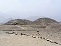
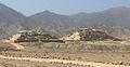
The Caral temples in the dry Supe Valley, about 20 km from the Pacific coast.
-
-
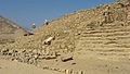
Caral in 2017


Amazing Discoveries at Caral
Paul Kosok first discovered Caral in 1948. At first, it didn't get much attention. This was because it didn't have the usual artifacts archaeologists looked for in the Andes.
In 1975, a Peruvian architect named Carlos Williams carefully recorded many sites in the Supe valley. Caral was one of them. His observations helped us understand how architecture developed in the Andes.
Later, archaeologist Ruth Shady explored Caral further. She uncovered a huge city with temples, an amphitheater, and homes. This ancient city is between 4,000 and 4,600 years old. It covers 150 hectares (about 370 acres) and includes plazas and residential buildings. Caral was a thriving city around the same time the great pyramids were being built in Egypt!
Caral is the largest known site in the Andean region that is older than 2000 BC. It seems to have been a model for how later Andean civilizations designed their cities. Studying Caral might help us learn about the very beginnings of the Andean civilizations and their first cities.
Ancient Record Keeping: The Quipu
Among the artifacts found at Caral is a special knotted textile piece. Archaeologists call this a quipu. This discovery suggests that the quipu system is much older than previously thought. The Inca Empire later used quipus to keep detailed records. Some experts, like Gary Urton, believe quipus might have even recorded information like writing, using a special code.
The Main Temple
The main temple complex at Caral is huge! It's 150 meters (about 490 feet) long, 110 meters (about 360 feet) wide, and 28 meters (about 90 feet) high. We don't know the exact date it was built.
A Peaceful Society
Ruth Shady's findings suggest that Caral was a peaceful society. It seems to have been built on trade and enjoyment. No signs of war, like weapons or battle scars, have been found at Caral. This is different from an older civilization at Sechin Bajo, where images of weapons are seen.
In one of the temples, archaeologists found 32 flutes made from condor and pelican bones. They also found 37 cornetts made from deer and llama bones. Another discovery was the remains of a baby, carefully wrapped and buried with a necklace of stone beads.
The Scope of Caral
Caral was the center of a larger civilization. It influenced 19 other temple complexes spread across the 90 square kilometer (35 square mile) area of the Supe Valley.
The age of Caral (2627 BC) was determined by carbon dating. This method looks at the age of reed and woven bags found at the site. These bags were used to carry stones for building the temples. This material is great for getting very accurate dates. The site might even be older, as some of the oldest parts haven't been dated yet.
Caral itself had about 3,000 people. But with the 19 other sites in the area, the total population sharing the same culture in the Supe Valley could have been around 20,000 people. All these sites are similar to Caral, with small platforms or stone circles. Shady believes Caral was the most important city. It was part of an even bigger cultural network, trading with coastal communities and areas further inland, possibly even the Amazon region.

The Caral Geoglyph
In 2000, Marco Machacuay and Rocío Aramburú discovered a giant shape etched into the ground near Caral. This image is called a geoglyph. It's located on the desert floor west of the main Caral site. When you trace the lines, they form a human face with long, flowing hair and an open mouth.
This geoglyph looks a bit like figures found on stone walls at a site called Cerro Sechín, about 240 km (150 miles) north. What this figure means isn't clear. However, it's thought to have been made around the same time as Caral. It was likely connected to a nearby ceremonial site called Chupacigarro.
Ancient Musical Instruments
Another exciting discovery at Caral was a collection of musical instruments. This included 37 cornetts made from deer and llama bones. There were also 33 flutes with a unique design. The flutes were carbon-dated to about 2170 BC.
How Caral Was Organized
The city of Caral was divided into two main parts: an "Upper Half" and a "Lower Half." The Supe River Valley naturally separated these two areas.
The Upper Half
In the Upper Half, there were six large building complexes. Each complex included a pyramid, an open plaza, and a group of residential buildings. These pyramids were called the "Great Temple/Great Pyramid," "Central Pyramid," "Quarry Pyramid," "Lesser Pyramid," "Pyramid of the Gallery," and "Pyramid of the Huanca."
The homes around these pyramids show signs of wealthy people living there. For example, archaeologists found bones from sea lions, which would have been special food for the rich. Many people living in the Upper Half of Caral were likely important leaders or priests. Their lives probably involved religious and social events that took place in the temples.
The Lower Half
In contrast, the residential buildings in the Lower Half show less evidence of wealthy people. These homes were smaller, and single rooms were used for many different purposes. The people living in the Lower Half of Caral mostly ate plants from farming and some fish. Their diets were simpler than those of the wealthy people in the Upper Half.
Experts believe the city was planned this way on purpose. The grand buildings in the Upper Half were designed to house the wealthy and show their power. The Lower Half was built for the workers. The river acted as a clear boundary between these two groups. This kind of city planning shows that there was a clear social structure in Caral, with different groups of people having different levels of importance.
See also
 In Spanish: Caral para niños
