Carbondale, Colorado facts for kids
Quick facts for kids
Carbondale, Colorado
|
|
|---|---|
| Town of Carbondale | |

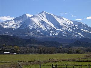
Mount Sopris, south of the town, looms close by.
|
|
| Nickname(s):
The Ultimate Rocky Mountain Hideout
|
|

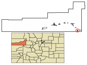
Location of the Town of Carbondale in Garfield County, Colorado.
|
|
| Country | |
| State | |
| County | Garfield |
| Incorporated (town) | April 26, 1888 |
| Government | |
| • Type | Home rule municipality |
| Area | |
| • Total | 2.022 sq mi (5.237 km2) |
| • Land | 2.022 sq mi (5.237 km2) |
| • Water | 0 sq mi (0.000 km2) |
| Elevation | 6,204 ft (1,891 m) |
| Population
(2020)
|
|
| • Total | 6,434 |
| • Density | 3,182/sq mi (1,229/km2) |
| • Metro | 79,043 |
| • CSA | 134,774 |
| Time zone | UTC−07:00 (MST) |
| • Summer (DST) | UTC−06:00 (MDT) |
| ZIP code |
81623
|
| Area code(s) | 970 |
| FIPS code | 08-12045 |
| GNIS feature ID | 2413166 |
The Town of Carbondale is a special type of town called a home rule municipality. It is located in Garfield County, Colorado, in the United States. In 2020, about 6,434 people lived there. Carbondale is part of the larger Glenwood Springs, CO Micropolitan Statistical Area.
The town is found in the Roaring Fork Valley, which is a beautiful area. It sits on the south side of the Roaring Fork River, close to where the Crystal River joins it. A huge mountain called Mount Sopris, which is 12,953 feet (3,952 meters) tall, stands proudly to the south of Carbondale. Carbondale is also the starting point for the West Elk Loop Scenic and Historic Byway, a scenic road trip.
Contents
History and Culture
For a long time, the Roaring Fork and Crystal Valleys were seasonal homes and hunting grounds for the Ute people, specifically the Parianuche and Yampa bands. After 1879, more and more white settlers and prospectors came to the area, even though there were treaties with the Utes.
Carbondale got its name from Carbondale, Pennsylvania, which was the hometown of some of the first people who settled here. At first, Carbondale's economy was all about farming and ranching. Farmers grew food for the miners in nearby Aspen, which was a busy silver mining town back then.
In the early 1900s, before big farms grew potatoes everywhere, Carbondale was famous for its potatoes. This history is still celebrated today with Potato Day, an annual fall parade and cookout held in Sopris Park.
Even though the town's name sounds like "carbon" (coal), it wasn't named for coal. However, there actually are a lot of coal resources in the Carbondale area. Until the late 1980s, coal mining was a big part of Carbondale's economy. The coal from this area was special because it burned very hot, had little sulfur, and was dense. But the coal mines also had a lot of methane gas. In 1981, a serious accident happened when a methane gas explosion killed 15 miners. By 1991, the mines had to close permanently.
As Aspen became a popular place for skiing, the cost of homes there became very high. This meant that many people who worked in Aspen had to live in other towns, like Carbondale. So, since the 1980s, Carbondale has become a bedroom community, meaning many people live there and travel to work in Aspen or Glenwood Springs. More recently, Carbondale has also seen a lot of new homes built for vacations, and it has become a popular spot for arts, outdoor fun, and tourism.
Community Events and Groups
Carbondale has many exciting events and community groups.
- The biggest yearly event is the Mountain Fair, a summer arts and music festival held in Sopris Park. It attracts between 18,000 and 20,000 people over three days, which is much more than Carbondale's population! This event is run by and helps support Carbondale Arts, a group that organizes other art programs all year.
- The popular Carbondale Wild West Rodeo happens every Thursday night during the summer. You can see exciting events like bronc riding, calf scramble, hide racing, and ribbon roping.
- KDNK is a community radio station based in Carbondale.
- The Third Street Center is a local place that used to be an elementary school. Now, it's a hub for many community groups and non-profit organizations.
- You can find changing art shows at the Carbondale Clay Center, Carbondale Arts' R2 Gallery, and The Powers Art Center.
- The Carbondale Creative District is a special area recognized by the state of Colorado for its focus on arts and creativity.
Geography
In 2020, the town of Carbondale covered an area of about 5.237 square kilometers (about 2 square miles), and all of it is land.
Population Information
| Historical population | |||
|---|---|---|---|
| Census | Pop. | %± | |
| 1890 | 166 | — | |
| 1900 | 173 | 4.2% | |
| 1910 | 284 | 64.2% | |
| 1920 | 310 | 9.2% | |
| 1930 | 283 | −8.7% | |
| 1940 | 437 | 54.4% | |
| 1950 | 441 | 0.9% | |
| 1960 | 612 | 38.8% | |
| 1970 | 726 | 18.6% | |
| 1980 | 2,084 | 187.1% | |
| 1990 | 3,004 | 44.1% | |
| 2000 | 5,196 | 73.0% | |
| 2010 | 6,427 | 23.7% | |
| 2020 | 6,434 | 0.1% | |
| U.S. Decennial Census | |||
As of the year 2000, there were 5,196 people living in Carbondale. About 41.1% of the homes had children under 18 living there. The average age of people in the town was 31 years old.
Education
Carbondale is part of the Roaring Fork School District.
Elementary and Middle Schools
- Crystal River Elementary School
- Carbondale Middle School
- Carbondale Community School
- Ross Montessori School
- Waldorf School on the Roaring Fork
High Schools
- Roaring Fork High School (RFHS)
- Bridges High School (BHS)
- Colorado Rocky Mountain School (CRMS)
Higher Education
Colorado Mountain College has a campus right in Carbondale. Another campus, CMC’s Spring Valley at Glenwood Springs, is also close by, just north of town.
Transportation
The Roaring Fork Transportation Authority (RFTA) provides bus service in Carbondale, helping people get around. There's also a free transportation service called Downtowner that operates in Carbondale.
See also
 In Spanish: Carbondale (Colorado) para niños
 | Jessica Watkins |
 | Robert Henry Lawrence Jr. |
 | Mae Jemison |
 | Sian Proctor |
 | Guion Bluford |


