
Carrick Roads facts for kids
Carrick Roads (in Cornish, Dowr Carrek, meaning "rock anchorage") is a large natural harbour in Cornwall, England. It's where the River Fal meets the sea, close to the town of Falmouth. This important waterway connects to the English Channel at its southern end.
Contents
Geography of Carrick Roads
Carrick Roads was formed a long time ago, after the last Ice age. As the ice melted, sea levels rose and flooded a valley, creating this big natural harbour. You can sail boats all the way from Falmouth to Truro here.
The water in Carrick Roads moves a lot with the tides. The currents can be quite strong, especially in the narrower parts. This area is also a great place for kayakers, with the journey from Truro to Falmouth being a top route.
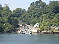
You can get a great view of Carrick Roads from the Trelissick Peninsula. From there, you can see the water stretching towards Falmouth. You'll spot Camerance Point, covered in trees, and the Feock Peninsula. Beyond that is a creek leading to Mylor village, with the wider Fal Estuary in the distance. Nearby are the beautiful gardens of Trelissick House, filled with many different trees and colourful flowers.
A special ferry called the King Harry Ferry crosses the Roads. It's a chain ferry that connects the villages of Feock and Philleigh. It's a fun and scenic way to cross the water!
Wildlife and Nature
Carrick Roads and the Fal Estuary are fantastic places for birdwatching. Many different kinds of birds, especially waders and waterbirds, visit in autumn and winter.
You can see little egrets and kingfishers all year round. In spring, late summer, and autumn, many waders pass through, like the Whimbrel, spotted redshank, greenshank, common sandpiper, curlew sandpiper, and little stint.
In winter, you might spot larger diving birds such as the great northern diver and black-throated diver. Other winter visitors include the black-necked grebe, red-necked grebe, Slavonian grebe, goldeneye, and red-breasted merganser. Sometimes, you can even see the long-tailed duck and the scoter.
Why Carrick Roads is Important for Ships
The Fal Estuary is one of the largest natural harbours in the world. Carrick Roads itself is about 4 miles (6.4 km) long and at least 1 mile (1.6 km) wide. It's also very deep, often 12-14 metres (39-46 feet) in many places. This makes it a perfect place for large ships to anchor safely.
Because it's so deep and wide, Carrick Roads has always been an important anchorage. It's like a safe parking spot for ships coming from the Atlantic Ocean and the Mediterranean Sea.
Hundreds of years ago, Henry VIII worried about attacks from other countries. He planned to build five forts to protect this important harbour. Only two were built: Pendennis Castle and St Mawes Castle. These castles were finished between 1540 and 1542.
Today, Carrick Roads is still used by ships. When ships are not being used, or are waiting for new owners, they can be "laid up" here. This means they are safely anchored in the deep, calm waters until they are needed again.
Past Industries
In the 1880s, people still fished for pilchards here. Fishermen would use large nets called seines. They even had a "huer," a lookout on a hill, who would watch for shoals of fish in the water.
The oyster beds in Mylor and St Just-in-Roseland were once very busy. However, in 1883, they were closed for two years. This was because too many oysters had been taken, and the beds needed time to recover.
How Carrick Roads is Managed
The Falmouth Harbour Commissioners are in charge of managing the harbour. They look after the inner harbour at Falmouth, the Penryn River, and a large part of Carrick Roads and Falmouth Bay. They also set rules, like speed limits, for boats in Carrick Roads to keep everyone safe.
Gallery
-
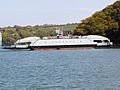
King Harry Ferry between Trelissick and Roseland
-
Carrick Roads near Trelissick
-
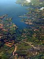
An aerial view showing Carrick Roads, Truro and Falmouth
-
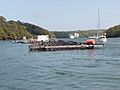
The Feock terminal of the King Harry Ferry in 2005
-
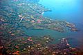
Carrick Roads in Cornwall bordered by Penryn, Falmouth & St. Mawes. Taken from flight AF0349


Images for kids
-
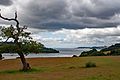
Carrick Roads, estuary of the River Fal. Viewed from Trelissick
-
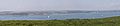
Carrick Roads, as seen from Roseland


See also
 In Spanish: Carrick Roads para niños
