Carthage, Tennessee facts for kids
Quick facts for kids
Carthage, Tennessee
|
|
|---|---|

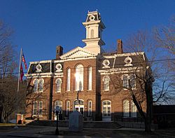
Smith County Courthouse in Carthage
|
|

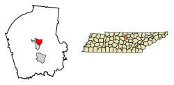
Location of Carthage in Smith County, Tennessee.
|
|
| Country | United States |
| State | Tennessee |
| County | Smith |
| Settled | 1789 |
| Incorporated | 1804 |
| Named for | Ancient Carthage |
| Area | |
| • Total | 2.90 sq mi (7.52 km2) |
| • Land | 2.90 sq mi (7.52 km2) |
| • Water | 0.00 sq mi (0.00 km2) |
| Elevation | 515 ft (157 m) |
| Population
(2020)
|
|
| • Total | 2,291 |
| • Density | 789.46/sq mi (304.78/km2) |
| Time zone | UTC-6 (Central (CST)) |
| • Summer (DST) | UTC-5 (CDT) |
| ZIP code |
37030
|
| Area code(s) | 615 |
| FIPS code | 47-11280 |
| GNIS feature ID | 1279827 |
Carthage is a town in Smith County, Tennessee. It is the main town, also known as the county seat, of Smith County. Carthage is part of the larger Nashville Metropolitan Statistical Area, which means it's connected to the big city of Nashville.
In 2010, about 2,306 people lived here. The town is located right on the Cumberland River. This river was very important for the town's growth a long time ago. Carthage is also famous for being the hometown of Al Gore, who was a Vice President of the United States. His father, Albert Gore, Sr., was also a Senator. Al Gore announced his plans to run for president and vice president from the courthouse steps in Carthage.
Contents
History of Carthage
Early Settlers and Growth
The first known European-American person to settle in the Carthage area was William Walton. He arrived in the late 1780s, after the American Revolutionary War ended. Around 1800, Walton helped build the Walton Road, also called the Cumberland Turnpike. This was an early road for stagecoaches. It connected the Knoxville area in the east with Middle Tennessee.
This road was very important for people settling in the Cumberland region. Walton also ran a ferry across the Cumberland River and a nearby inn. A small community grew around these places. In 1804, Walton's community was chosen as the county seat for the new Smith County. Soon after, the town of Carthage was planned out.
River Port and Civil War Times
Carthage is located where the Caney Fork and Cumberland rivers meet. This made it a very important port for shipping goods and for steamboats in the early 1800s. Farmers in the area grew crops like tobacco and hemp. They also raised special livestock. These goods were shipped down the river to Nashville.
During the American Civil War, Carthage became an important spot in Eastern Tennessee. Confederate General Braxton Bragg marched his army through Carthage on their way to Kentucky. Later, in 1863, Union General George Crook set up a Union base in Carthage. This base helped clear out Confederate fighters from the area.
Changes in Transportation
Carthage was a major river port, but this changed when railroads became popular in the late 1800s. Trains started carrying goods instead of steamboats. Because of this, the main industrial focus shifted to nearby South Carthage and Gordonsville.
Geography of Carthage
Carthage is located at 36°15′18″N 85°56′57″W / 36.25500°N 85.94917°W. The town sits among low hills where the Caney Fork river joins the Cumberland River. It is also just southwest of the Cordell Hull Lake, which is part of the Cumberland River. South Carthage is located on the other side of the Cumberland River.
Roads and Connections
U.S. Route 70 goes through South Carthage from east to west. This road connects the area to Nashville in the west and Cookeville in the east. State Route 53 connects U.S. 70 to Gordonsville and Interstate 40 to the south.
State Route 25 links Carthage to Trousdale County and north-central Tennessee. State Route 80 connects the town to Macon County to the north.
The United States Census Bureau says that Carthage covers about 2.9 square miles (7.52 square kilometers) of land. There is no water area within the town limits.
People of Carthage (Demographics)
| Historical population | |||
|---|---|---|---|
| Census | Pop. | %± | |
| 1870 | 477 | — | |
| 1880 | 327 | −31.4% | |
| 1890 | 478 | 46.2% | |
| 1910 | 904 | — | |
| 1920 | 920 | 1.8% | |
| 1930 | 1,068 | 16.1% | |
| 1940 | 1,512 | 41.6% | |
| 1950 | 1,604 | 6.1% | |
| 1960 | 2,021 | 26.0% | |
| 1970 | 2,491 | 23.3% | |
| 1980 | 2,672 | 7.3% | |
| 1990 | 2,386 | −10.7% | |
| 2000 | 2,251 | −5.7% | |
| 2010 | 2,306 | 2.4% | |
| 2020 | 2,291 | −0.7% | |
| Sources: | |||
2020 Census Information
In 2020, the United States census counted 2,291 people living in Carthage. There were 947 households and 528 families in the town. Most of the people living in Carthage were White (86.6%). About 4.58% were Black or African American, and 1.13% were Asian. About 3.84% of the people identified as Hispanic or Latino.
Education
Carthage and the areas around it in Smith County are served by the Smith County Schools system. The Smith County Board of Education manages these schools.
Here are some of the schools in the area:
- Carthage Elementary
- Defeated Elementary
- New Middleton Elementary
- Union Heights Elementary
- Forks River Elementary
- Smith County Middle School
- Gordonsville High School
- Smith County High School
- Smith County Adult Education
- Smith County HeadStart
Climate
The weather in Carthage is known for hot, humid summers. Winters are usually mild to cool. This type of weather is called a humid subtropical climate. On climate maps, it's often shown as "Cfa."
| Climate data for carthage, Tennessee (1991–2020 normals, extremes 1890–present) | |||||||||||||
|---|---|---|---|---|---|---|---|---|---|---|---|---|---|
| Month | Jan | Feb | Mar | Apr | May | Jun | Jul | Aug | Sep | Oct | Nov | Dec | Year |
| Record high °F (°C) | 88 (31) |
83 (28) |
92 (33) |
95 (35) |
98 (37) |
105 (41) |
110 (43) |
111 (44) |
108 (42) |
97 (36) |
87 (31) |
77 (25) |
111 (44) |
| Mean daily maximum °F (°C) | 48.1 (8.9) |
52.5 (11.4) |
61.4 (16.3) |
71.3 (21.8) |
78.7 (25.9) |
85.7 (29.8) |
89.0 (31.7) |
88.4 (31.3) |
83.7 (28.7) |
73.1 (22.8) |
61.5 (16.4) |
51.7 (10.9) |
70.4 (21.3) |
| Daily mean °F (°C) | 37.6 (3.1) |
41.1 (5.1) |
48.8 (9.3) |
57.9 (14.4) |
66.4 (19.1) |
74.2 (23.4) |
78.1 (25.6) |
76.8 (24.9) |
71.3 (21.8) |
59.8 (15.4) |
48.8 (9.3) |
41.1 (5.1) |
58.5 (14.7) |
| Mean daily minimum °F (°C) | 27.0 (−2.8) |
29.6 (−1.3) |
36.1 (2.3) |
44.5 (6.9) |
54.1 (12.3) |
62.8 (17.1) |
67.1 (19.5) |
65.2 (18.4) |
58.8 (14.9) |
46.5 (8.1) |
36.0 (2.2) |
30.4 (−0.9) |
46.5 (8.1) |
| Record low °F (°C) | −17 (−27) |
−15 (−26) |
3 (−16) |
21 (−6) |
30 (−1) |
40 (4) |
49 (9) |
46 (8) |
32 (0) |
23 (−5) |
0 (−18) |
−9 (−23) |
−17 (−27) |
| Average precipitation inches (mm) | 4.49 (114) |
4.86 (123) |
5.01 (127) |
4.41 (112) |
4.73 (120) |
5.03 (128) |
4.97 (126) |
3.71 (94) |
3.40 (86) |
3.43 (87) |
3.55 (90) |
4.92 (125) |
52.51 (1,334) |
| Average snowfall inches (cm) | 0.5 (1.3) |
0.7 (1.8) |
0.2 (0.51) |
0.0 (0.0) |
0.0 (0.0) |
0.0 (0.0) |
0.0 (0.0) |
0.0 (0.0) |
0.0 (0.0) |
0.0 (0.0) |
0.0 (0.0) |
0.1 (0.25) |
1.5 (3.8) |
| Average precipitation days (≥ 0.01 in) | 10.2 | 10.2 | 10.8 | 10.2 | 10.3 | 9.8 | 10.1 | 8.0 | 7.4 | 7.4 | 8.3 | 10.3 | 113.0 |
| Average snowy days (≥ 0.1 in) | 0.7 | 0.6 | 0.2 | 0.0 | 0.0 | 0.0 | 0.0 | 0.0 | 0.0 | 0.0 | 0.1 | 0.2 | 1.8 |
| Source: NOAA | |||||||||||||
Notable People from Carthage
Many interesting people have come from Carthage, Tennessee:
- William Cullom – A Congressman, which means he helped make laws for the country.
- James Comer – Also a Congressman.
- Albert Gore, Sr. – A U.S. Senator, who represented Tennessee in the national government.
- Albert Gore, Jr. – A U.S. Senator and later the Vice President of the United States.
- Simon Pollard Hughes, Jr. – He was the Governor of Arkansas from 1885 to 1889. A governor leads a state.
- Cordell Hull – He was the U.S. Secretary of State, a very important job in foreign relations. He also practiced law in Carthage.
- Brandon Maggart – An actor.
- George McCorkle – A founding member of the Marshall Tucker Band, a famous music group.
- Benton McMillin – He was the Governor of Tennessee from 1899 to 1903.
- Sharon Wyatt – An actress known for her roles in TV shows like General Hospital and Passions.
- Keith Habersberger – A popular YouTube creator and musician.
See also
 In Spanish: Carthage (Tennessee) para niños
 | Emma Amos |
 | Edward Mitchell Bannister |
 | Larry D. Alexander |
 | Ernie Barnes |


