
Trousdale County, Tennessee facts for kids
Quick facts for kids
Trousdale County
|
|
|---|---|
| Hartsville-Trousdale County | |

Trousdale County Courthouse in Hartsville
|
|

Location within the U.S. state of Tennessee
|
|
 Tennessee's location within the U.S. |
|
| Country | |
| State | |
| Founded | September 5, 1870 |
| Named for | William Trousdale |
| Seat | Hartsville |
| Largest town | Hartsville |
| Area | |
| • Total | 117 sq mi (300 km2) |
| • Land | 114 sq mi (300 km2) |
| • Water | 2.5 sq mi (6 km2) 2.1%% |
| Population
(2020)
|
|
| • Total | 11,615 |
| • Density | 69/sq mi (27/km2) |
| Time zone | UTC−6 (Central) |
| • Summer (DST) | UTC−5 (CDT) |
| Congressional district | 6th |
Trousdale County, also known as Hartsville/Trousdale County, is a county in the U.S. state of Tennessee. In 2020, about 11,615 people lived there. Its main town is Hartsville. The county and Hartsville share a special combined government. Trousdale County is Tennessee's smallest county, covering only about 117 square miles (303 square kilometers).
Trousdale County is part of the larger Nashville area. This area is a big group of cities and towns that are connected. Trousdale County is a bit outside the main ring of towns where many people live and commute to Nashville for work. The county is mostly rural, meaning it has lots of open land. Many people here work in farming and raising livestock (farm animals).
Hartsville is the county seat, which means it's where the county government is located. Trousdale County High School is in Hartsville. There is also a technical school that helps students learn job skills. Trousdale County is one of only two counties in Tennessee where horse racing bets are allowed. However, no one has built a racetrack there yet.
In 2016, a large prison called the Trousdale Turner Correctional Center opened in Hartsville. This prison holds many people. During the COVID-19 pandemic in 2020, the prison had a lot of COVID-19 cases. This made Trousdale County have one of the highest infection rates in the U.S. at that time.
Contents
History of Trousdale County
Trousdale County was created in 1870. It was formed from parts of four other counties: Macon, Smith, Sumner, and Wilson counties. The county was named after William Trousdale (1790–1872). He was a general in the Mexican War and also served as the Governor of Tennessee. He was even a U.S. ambassador to Brazil. People in Hartsville first tried to create their own county back in 1849, but it didn't happen then.
The Battle of Hartsville
On December 7, 1862, a battle happened in the area that would later become Trousdale County. This was during the American Civil War. Confederate forces, led by John Hunt Morgan, surprised and defeated the Union forces. Morgan's troops captured most of the Union soldiers. They then marched them south to Lebanon.
Floods and Economic Changes
In the early 1900s, several big floods hit Hartsville. The water was so high that it reached nine to twelve feet in some places. There are old photos showing people using canoes in front of the flooded courthouse.
During World War II, American soldiers often trained in Trousdale County. They practiced battles and played war games on local farms. After the war, the county did well because a railroad ran through it. However, when the trains stopped using the county, businesses slowed down. This caused economic problems for the area.
Geography of Trousdale County

Trousdale County covers about 117 square miles (303 square kilometers). Most of this area, about 114 square miles (295 square kilometers), is land. The rest is water. It is the smallest county in Tennessee by land area.
Neighboring Counties
Trousdale County shares borders with these other counties:
- Macon County (to the north)
- Smith County (to the east)
- Wilson County (to the south)
- Sumner County (to the west)
Protected Natural Areas
Part of the Old Hickory Wildlife Management Area is located in Trousdale County. This area helps protect nature and wildlife.
Major Roads
Several important roads pass through Trousdale County:
 US 231
 SR 10
SR 10 SR 25
SR 25 SR 141
 SR 260
People of Trousdale County
| Historical population | |||
|---|---|---|---|
| Census | Pop. | %± | |
| 1880 | 6,646 | — | |
| 1890 | 5,850 | −12.0% | |
| 1900 | 6,004 | 2.6% | |
| 1910 | 5,874 | −2.2% | |
| 1920 | 5,996 | 2.1% | |
| 1930 | 5,629 | −6.1% | |
| 1940 | 6,113 | 8.6% | |
| 1950 | 5,520 | −9.7% | |
| 1960 | 4,914 | −11.0% | |
| 1970 | 5,155 | 4.9% | |
| 1980 | 6,137 | 19.0% | |
| 1990 | 5,920 | −3.5% | |
| 2000 | 7,259 | 22.6% | |
| 2010 | 7,870 | 8.4% | |
| 2020 | 11,615 | 47.6% | |
| U.S. Decennial Census 1790-1960 1900-1990 1990-2000 2010-2014 |
|||

The population of Trousdale County has changed over the years. In 1880, about 6,646 people lived there. By 2020, the population had grown to 11,615 people.
2020 Census Information
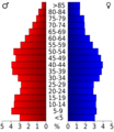
In 2020, there were 11,615 people living in Trousdale County. These people lived in 3,189 households. About 2,083 of these households were families.
| Race | Number | Percentage |
|---|---|---|
| White (not Hispanic) | 8,786 | 75.64% |
| Black or African American (not Hispanic) | 1,917 | 16.5% |
| Native American | 26 | 0.22% |
| Asian | 27 | 0.23% |
| Other/Mixed | 484 | 4.17% |
| Hispanic or Latino | 375 | 3.23% |
Communities in Trousdale County

Hartsville is the only official town in Trousdale County. It is the county seat. There are also a few smaller communities that are not officially towns:
Images for kids
-
Age pyramid Trousdale County
See also
 In Spanish: Condado de Trousdale para niños
