Hartsville, Tennessee facts for kids
Quick facts for kids
Hartsville, Tennessee
|
|
|---|---|
|
Consolidated city-county
|
|
| Hartsville-Trousdale County | |

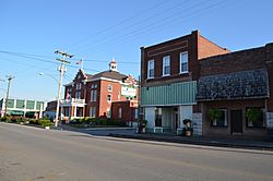
Downtown Hartsville
|
|
| Country | |
| State | |
| County | Trousdale |
| Settled | 1797 |
| Founded | 1817 |
| Incorporated | 1840 |
| Founded by | James Hart, early settler |
| Area | |
| • Total | 3.6 sq mi (9.2 km2) |
| • Land | 3.6 sq mi (9.2 km2) |
| • Water | 0.0 sq mi (0.0 km2) |
| Elevation | 472 ft (144 m) |
| Population
(2020)
|
|
| • Total | 11,615 |
| • Density | 673.5/sq mi (260.1/km2) |
| Time zone | UTC−06:00 (Central (CST)) |
| • Summer (DST) | UTC−05:00 (CDT) |
| ZIP code |
37074
|
| Area code(s) | 615 |
| FIPS code | 47-32720 |
| GNIS feature ID | 1287064 |
Hartsville is a town located in Trousdale County, Tennessee, in the United States. It is the main town and the county seat of Trousdale County. Hartsville and Trousdale County share a special type of government called a consolidated city-county government. This means the town and county work together as one unit for many services. In 2020, about 11,615 people lived in Hartsville.
Even with the shared government, Hartsville is still considered a separate town under Tennessee law. The town is home to Trousdale County High School and a campus of the Tennessee Colleges of Applied Technology. This campus helps students learn important job skills. Trousdale County is one of only two counties in Tennessee where horse racing bets are allowed, but no racetrack has been built yet. Hartsville is located near the Cumberland River, about 50 miles northeast of Nashville.
In 1977, the Tennessee Valley Authority started building the Hartsville Nuclear Plant. However, the project was stopped in 1984 after almost $2 billion had been spent. You can still see the plant's unused cooling tower from State Route 25. In 2016, a company called CoreCivic opened the Trousdale Turner Correctional Center, which is a medium-security prison, in Hartsville.
Contents
Discovering Hartsville's Past
The first European-American settlers arrived in the Hartsville area in 1797. The family of James Hart settled on the west side of the West Fork of Goose Creek. The family of Charles Donoho settled on the east side. Donoho built a mill soon after. Because of this, the town was first known as Donoho's Mill.
James Hart also started Hart's Ferry along the Cumberland River a few miles south. In 1800, he bought Donoho's property. Hartsville was officially recognized as a town in 1817. The area known as "Damascus" (which was Donoho's Mill) joined with Hartsville in 1840 when Hartsville officially became an incorporated town.
During the Civil War, Hartsville was the location of an important battle. The Battle of Hartsville took place here in 1862.
Trousdale County is famous for its high school football teams. The TSSAA has awarded Trousdale County High School the fourth most state championships in football. They have won many titles, including in 1972, 1990, 1993, 1997, 1998, 2005, 2008, 2009, and 2013. They were also runners-up in 1973, 1974, 1975, and 2018.
Learning in Trousdale County
Trousdale County has three public schools for its students. These are Trousdale County High School, Trousdale County Elementary School, and Jim B. Satterfield Middle School.
In October 2013, the Trousdale County school district won a special award. They received the State Collaborative on Reforming Education (SCORE) Prize. This award is given to school districts that have greatly improved how well their students learn. Trousdale County schools serve over 1,200 students. They have done a great job helping students from different backgrounds achieve more in science. They have also shown strong growth in math and Biology I.
Exploring Hartsville's Geography
Hartsville is located at 36°23′30″N 86°9′37″W / 36.39167°N 86.16028°W. The main business area of the town is along the West Fork of Goose Creek. This creek flows into Trousdale County from the northern hills. It then empties into Old Hickory Lake, which is part of the Cumberland River, a few miles to the south. A large hill rises just west of the business district. It offers a view of the entire eastern half of the county.
Hartsville is where two main roads meet. State Route 25 connects the town to Carthage to the southeast and Sumner County to the west. State Route 141 connects Hartsville to Lebanon to the south and Macon County to the north.
According to the United States Census Bureau, Hartsville covers a total area of 3.6 square miles (9.2 square kilometers). All of this area is land.
Hartsville's Weather Patterns
| Climate data for Hartsville, Tennessee, 1991–2020 normals, extremes 1998–2015 | |||||||||||||
|---|---|---|---|---|---|---|---|---|---|---|---|---|---|
| Month | Jan | Feb | Mar | Apr | May | Jun | Jul | Aug | Sep | Oct | Nov | Dec | Year |
| Record high °F (°C) | 77 (25) |
77 (25) |
85 (29) |
89 (32) |
93 (34) |
98 (37) |
101 (38) |
105 (41) |
100 (38) |
92 (33) |
83 (28) |
78 (26) |
105 (41) |
| Mean daily maximum °F (°C) | 47.8 (8.8) |
51.7 (10.9) |
60.4 (15.8) |
70.5 (21.4) |
78.2 (25.7) |
84.9 (29.4) |
88.2 (31.2) |
88.2 (31.2) |
82.8 (28.2) |
72.1 (22.3) |
60.3 (15.7) |
50.2 (10.1) |
69.6 (20.9) |
| Daily mean °F (°C) | 37.1 (2.8) |
40.8 (4.9) |
48.3 (9.1) |
57.6 (14.2) |
65.9 (18.8) |
73.3 (22.9) |
77.0 (25.0) |
76.4 (24.7) |
70.7 (21.5) |
58.9 (14.9) |
48.2 (9.0) |
40.3 (4.6) |
57.9 (14.4) |
| Mean daily minimum °F (°C) | 26.5 (−3.1) |
29.8 (−1.2) |
36.1 (2.3) |
44.6 (7.0) |
53.6 (12.0) |
61.8 (16.6) |
65.8 (18.8) |
64.5 (18.1) |
58.6 (14.8) |
45.7 (7.6) |
36.1 (2.3) |
30.5 (−0.8) |
46.1 (7.9) |
| Record low °F (°C) | −6 (−21) |
−7 (−22) |
9 (−13) |
21 (−6) |
29 (−2) |
43 (6) |
48 (9) |
48 (9) |
35 (2) |
26 (−3) |
15 (−9) |
7 (−14) |
−7 (−22) |
| Average precipitation inches (mm) | 4.15 (105) |
4.49 (114) |
4.55 (116) |
4.39 (112) |
5.99 (152) |
4.43 (113) |
4.52 (115) |
3.71 (94) |
3.93 (100) |
3.50 (89) |
4.61 (117) |
4.90 (124) |
53.17 (1,351) |
| Source 1: NOAA (precipitation 1981–2010) | |||||||||||||
| Source 2: XMACIS2 | |||||||||||||
Understanding Hartsville's Population
| Historical population | |||
|---|---|---|---|
| Census | Pop. | %± | |
| 1920 | 1,023 | — | |
| 1930 | 1,015 | −0.8% | |
| 1940 | 1,095 | 7.9% | |
| 1950 | 1,130 | 3.2% | |
| 1960 | 1,712 | 51.5% | |
| 1970 | 2,243 | 31.0% | |
| 1980 | 2,674 | 19.2% | |
| 1990 | 2,188 | −18.2% | |
| 2000 | 2,395 | 9.5% | |
| 2010 | 7,870 | 228.6% | |
| 2020 | 11,615 | 47.6% | |
| Sources: | |||
In 2000, there were 2,395 people living in Hartsville. These people lived in 938 households, with 601 of them being families. The town had about 673.5 people per square mile.
About 75.70% of the people were White, and 22.46% were African American. A small number of people were Native American, Asian, or Pacific Islander. About 1.46% of the population identified as Hispanic or Latino.
About 29.1% of households had children under 18 living with them. About 42.2% of households were married couples. Around 18.9% were female householders without a husband present. About 31.2% of all households were individuals living alone. The average household had 2.38 people, and the average family had 2.96 people.
The median age in the town was 39 years old. This means half the people were younger than 39 and half were older. About 23.3% of the population was under 18 years old.
Famous People from Hartsville
- Bob Dyer – A well-known radio and television host.
- William Lauderdale – A planter and soldier who fought in the War of 1812 and the Second Seminole War.
- John Martin – A lawyer and politician who represented Kansas in the United States Senate from 1893 to 1895.
See also
 In Spanish: Hartsville (Tennessee) para niños
 | Janet Taylor Pickett |
 | Synthia Saint James |
 | Howardena Pindell |
 | Faith Ringgold |


