Casa Diablo Hot Springs facts for kids
Quick facts for kids Casa Diablo Hot Springs |
|
|---|---|

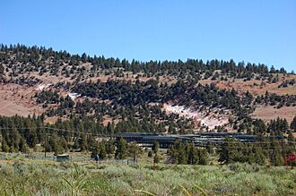
The power plant (bottom) with the formerly active geothermal areas on the slope above (white areas)
|
|
| Location | Mono County, California |
| Coordinates | 37°38′47″N 118°54′57″W / 37.64639°N 118.91583°W |
| Elevation | 7,319 feet (2,231 m) |
Casa Diablo Hot Springs is a cool place in eastern California. It has hot springs and lots of geothermal energy. This means there's heat coming from deep inside the Earth!
You can find Casa Diablo Hot Springs near Mammoth Lakes. It's also close to the beautiful Eastern Sierra Nevada mountains in Mono County.
Where is Casa Diablo Hot Springs?
Casa Diablo Hot Springs is located in a special area called the Long Valley Caldera. This caldera is a huge bowl-shaped dip in the ground. It was formed by a massive volcanic eruption a long, long time ago.
The hot springs are right next to U.S. Highway 395. This is a major road that runs through California. Another road, California State Route 203, branches off here. It leads to the popular Mammoth Lakes area. This area is famous for its ski resort and Devils Postpile National Monument.
A Look Back in Time: History of Casa Diablo
Long ago, Casa Diablo Hot Springs was home to a geyser. A geyser is like a natural water fountain that shoots hot water and steam into the air!
Native American people used this area for a very long time. They mined a special rock called obsidian here. Obsidian is a dark, glassy rock that forms from cooled lava. It's very sharp when broken. Native Americans used it to make tools and weapons.
People from far away, like the Chumash people who lived near the coast, traded for obsidian from Casa Diablo. This shows how important this site was!
Later, in 1878, Casa Diablo became a stop for stagecoaches. Stagecoaches were like old-fashioned buses pulled by horses. They carried people and goods between towns. This stop was on the route from Bishop Creek to Bodie.
It was also a relay station for routes to mining towns. These towns included Mammoth City and Pine City. In 1881, the stage station closed. But the site was still used for many other businesses. It was a trading post, a resort, a tavern, and even a gas station!
Power from the Earth: Geothermal Energy
Today, Casa Diablo Hot Springs is home to the Mammoth Geothermal Complex. This is a power plant that uses the Earth's heat to make electricity. It's owned by a company called Ormat.
The geothermal plant started working in 1983. It uses the natural heat from deep underground. This heat turns water into steam. The steam then spins turbines, which create electricity. It's a clean and renewable way to get power!

