Castle Mountain (Alaska) facts for kids
Quick facts for kids Castle Mountain |
|
|---|---|

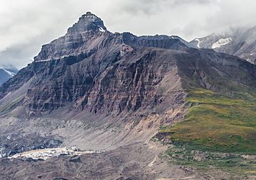
Castle Mountain, east aspect
|
|
| Highest point | |
| Elevation | 8,620 ft (2,630 m) |
| Prominence | 1,170 ft (360 m) |
| Isolation | 4.63 mi (7.45 km) |
| Geography | |
| Location | Wrangell-St. Elias National Park Valdez-Cordova Borough Alaska, United States |
| Parent range | Wrangell Mountains |
| Topo map | USGS McCarthy C-3 |
| Type of rock | Sedimentary rock |
Castle Mountain is a tall mountain in Alaska, United States. It stands 8,620 feet (2,630 meters) high. This mountain is found at the southeastern edge of the Wrangell Mountains. It is part of the huge Wrangell–St. Elias National Park and Preserve.
Castle Mountain is about 35 miles (56 kilometers) northeast of a town called McCarthy. It sits near a place known as Skolai Pass. Even though it's not the tallest mountain, its south side is very steep. It rises 4,000 feet (1,219 meters) from the Russell Glacier in less than a mile. Water from the mountain flows into the White River to the east. To the west, it flows into the Nizina River through Skolai Creek. The name "Castle Mountain" was given in 1914 by the United States Geological Survey.
Weather at Castle Mountain
Castle Mountain has a subarctic climate. This means it has long, cold, and snowy winters. The summers are usually cool. Weather systems from the Gulf of Alaska hit the Wrangell Mountains. This causes a lot of rain and snow to fall. This process is called orographic lift.
Temperatures can drop very low, sometimes below −20 °F (−29 °C). With wind, it can feel even colder, below −30 °F (−34 °C). The best time to visit or climb Castle Mountain is from May through June. The weather is usually nicer during these months.
 | Misty Copeland |
 | Raven Wilkinson |
 | Debra Austin |
 | Aesha Ash |


