Castle Peak (Colorado) facts for kids
Quick facts for kids Castle Peak |
|
|---|---|

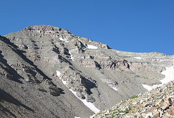
View from NNE above Montezuma Basin
|
|
| Highest point | |
| Elevation | 14272.3 ft (4350.20 m) NAPGD2022 |
| Prominence | 2365 ft (721 m) |
| Isolation | 20.9 mi (33.6 km) |
| Listing |
|
| Geography | |
| Location | High point of both Gunnison and Pitkin counties, Colorado, U.S. |
| Parent range | Highest summit of the Elk Mountains |
| Topo map | USGS 7.5' topographic map Hayden Peak, Colorado |
| Climbing | |
| First ascent | 1873 by the Hayden Survey |
| Easiest route | Northeast Ridge: Hike, class 2 |
Castle Peak is a very tall mountain in Colorado, United States. It is the ninth highest mountain in the entire Rocky Mountains of North America.
This amazing mountain is also the highest point in the Elk Mountains. It stands at 14,272 feet (4,350.20 m) (about 14,272 feet) tall! Mountains over 14,000 feet are often called "fourteeners" in Colorado.
Castle Peak is located about 11.6 miles (18.7 km) (11.6 miles) northeast of the Town of Crested Butte. It sits on the border between Gunnison County and Pitkin County, and it's the highest point in both counties.
Some people consider Castle Peak to be a holy mountain.
Contents
Exploring Castle Peak
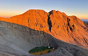
Castle Peak gets its name because its top looks like a castle. It has a unique shape that stands out.
Best Time to Climb
The best months to climb Castle Peak are June, July, August, and September. During these months, the weather is usually better for mountain adventures.
Climbing Routes
There are two main ways to climb Castle Peak. Both are considered "Class 2" climbs. This means you might need to use your hands for balance sometimes, but you won't need special climbing gear like ropes.
- Northwest Ridge: This route involves climbing over snow and then scrambling along a ridge. Scrambling means climbing over rocks using both your hands and feet. It's best to avoid this route late in the summer. This is because the ground near the top can become loose and slippery.
- Northeast Ridge: This route also has a snow climb. The scrambling and finding your way along the ridge can be a bit trickier here.
Conundrum Peak
Just north of Castle Peak is another peak called Conundrum Peak. It's like a smaller neighbor to Castle Peak. Conundrum Peak is about 0.4 miles (0.6 km) (0.6 km) away from Castle Peak.
Conundrum Peak is also very tall, reaching over 14,040 feet (4279 meters). Even though it's often climbed with Castle Peak, it's not usually considered a separate "fourteener" because it's so close to Castle Peak.
Mountain Weather
The weather on Castle Peak can be very cold, especially in winter. It gets a lot of snow. Summers are cooler than in the valleys below.
| Climate data for Castle Peak 39.0084 N, 106.8615 W, Elevation: 13,491 ft (4,112 m) (1991–2020 normals) | |||||||||||||
|---|---|---|---|---|---|---|---|---|---|---|---|---|---|
| Month | Jan | Feb | Mar | Apr | May | Jun | Jul | Aug | Sep | Oct | Nov | Dec | Year |
| Mean daily maximum °F (°C) | 21.9 (−5.6) |
21.3 (−5.9) |
26.4 (−3.1) |
31.6 (−0.2) |
40.5 (4.7) |
52.5 (11.4) |
57.4 (14.1) |
56.3 (13.5) |
49.8 (9.9) |
39.2 (4.0) |
28.3 (−2.1) |
22.0 (−5.6) |
37.3 (2.9) |
| Daily mean °F (°C) | 10.4 (−12.0) |
9.4 (−12.6) |
14.0 (−10.0) |
18.9 (−7.3) |
27.9 (−2.3) |
38.7 (3.7) |
44.1 (6.7) |
43.1 (6.2) |
36.6 (2.6) |
26.7 (−2.9) |
17.2 (−8.2) |
10.8 (−11.8) |
24.8 (−4.0) |
| Mean daily minimum °F (°C) | −1.2 (−18.4) |
−2.5 (−19.2) |
1.6 (−16.9) |
6.2 (−14.3) |
15.3 (−9.3) |
24.9 (−3.9) |
30.7 (−0.7) |
29.9 (−1.2) |
23.4 (−4.8) |
14.2 (−9.9) |
6.2 (−14.3) |
−0.4 (−18.0) |
12.4 (−10.9) |
| Average precipitation inches (mm) | 5.09 (129) |
5.30 (135) |
5.08 (129) |
5.73 (146) |
3.62 (92) |
1.53 (39) |
2.50 (64) |
2.72 (69) |
2.95 (75) |
3.87 (98) |
4.95 (126) |
4.74 (120) |
48.08 (1,222) |
| Source: PRISM Climate Group | |||||||||||||
See also
- List of mountain peaks of North America
- List of mountain peaks of the United States
- List of mountain peaks of Colorado
- List of Colorado county high points
- List of Colorado fourteeners
- List of mountain peaks of Colorado
- List of mountain peaks of the United States
 | Aaron Henry |
 | T. R. M. Howard |
 | Jesse Jackson |


