Cataractonium facts for kids
| Alternative name | Caturactonium Cactabactonion |
|---|---|
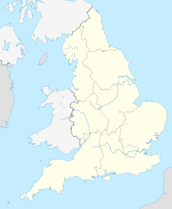
| Location | Catterick, North Yorkshire, England |
| Region | Brittania |
| Coordinates | 54°23′3″N 01°38′59″W / 54.38417°N 1.64972°W |
| Type | Fortification and settlement |
| Length | 135m |
| Width | 135m |
| Area | 1.8ha |
| History | |
| Builder | Quintus Petillius Cerialis |
| Founded | 71 |
| Periods | Roman Imperial |
Cataractonium was an important Roman fort and settlement in ancient Britain. It was located in what is now North Yorkshire, England. Over time, this Roman site grew into the modern town of Catterick.
Contents
What's in a Name?
The name Cataractonium probably comes from the Latin word cataracta. This word can mean either "waterfall" or "portcullis" (a strong gate that drops down to protect a castle or fort entrance).
Some experts think the Romans might have misunderstood an older Celtic name. This original name might have meant "place of battle ramparts" (defensive walls).
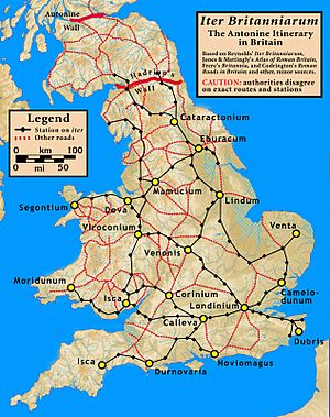
The name appears in old Roman documents. For example, it's mentioned in the 2nd-century Vindolanda tablets. It also shows up in the Antonine Itinerary, a Roman road guide.
Early History of the Site
Long before the Romans arrived, people lived in this area. Archaeologists have found signs of activity from the Bronze Age and Iron Age. These include ancient burial mounds called cairns and remains of roundhouses.
The Roman fort was likely built around AD 70. This was during the time of Governor Quintus Petillius Cerialis. The fort helped support Roman campaigns further north in Scotland. It was also probably used during a local revolt in AD 155.
The first fort was a simple timber structure on a hill. Later, a bigger settlement was built using stone. This new site also had a civilian population living alongside the soldiers.
Roman Soldiers at the Fort
We don't have exact records of which specific Roman army units were stationed at Cataractonium. However, it's thought that auxiliary units (soldiers who were not full Roman citizens) were posted here.
Tiles found nearby had "BSAR" stamped on them. This suggests that soldiers from units like the Ala II Asturum and Cuneus Sarmatarum might have been part of the fort's garrison over the years.
Daily Life and Culture
Archaeologists have found interesting items at Cataractonium. One discovery was a theatrical mask. This suggests that the settlement might have had a theatre or a small amphitheatre where people could watch performances.
Economy and Trade
In 1995, a special project used aerial mapping to study the site. They found at least sixteen clear building outlines and parts of others. These buildings were probably shops, showing that Cataractonium was a busy place for trade.

Important Roads
Cataractonium was a very important crossroads for Roman roads. The main road coming north from Eboracum (York) and Isurium (Aldborough) split here.
One branch, called Dere Street, went northeast to Vinovium (Binchester). The other branch, similar to what we now call Watling Street, went northwest to Lavatrae (Bowes). These roads were vital for moving soldiers and supplies to Hadrian's Wall and the Antonine Wall.
River Location
The fort was built just south of the River Swale. Its location was strategic. The early fort served as a camp for patrols in the area. It also protected the bridgehead (the area around the bridge) for the main Roman road.
Uncovering the Past: Archaeology
Today, not much of Cataractonium can be seen above ground. Most of the ancient site is covered by the Catterick Racecourse and the A1(M) road. However, a small section of the old wall is still visible.
Archaeologists have found evidence of at least four altars used for worship. These altars were dedicated to different gods:
- Veterus, an old German god.
- Suria, another name for the goddess Ceres.
- Matribus Domesticae, dedicated to the mother goddesses of the home.
- An unnamed god of "roads and pathways."
The 1995 aerial study also found signs of a temporary Roman fort. This smaller camp was located east of the main fort. Its walls, about 540 feet long on the north side and 850 feet long on the east, have been identified.
Early excavations unearthed interesting artifacts. These included two carved stone lions, a gold coin from Emperor Nero, and large bronze urns. The buildings found date from the 2nd to the 3rd centuries. There's also evidence that the fort's layout was changed in the 4th century.
More recently, between 2014 and 2016, new excavations took place. These were part of improvements to the A1 road. Thousands more artifacts from the Roman town were discovered during this work.
 | Jackie Robinson |
 | Jack Johnson |
 | Althea Gibson |
 | Arthur Ashe |
 | Muhammad Ali |


