Cathedral Rock (Coconino County, Arizona) facts for kids
Quick facts for kids Cathedral Rock |
|
|---|---|

Southeast aspect
|
|
| Highest point | |
| Elevation | 3,942 ft (1,202 m) |
| Prominence | 342 ft (104 m) |
| Isolation | 2.61 mi (4.20 km) |
| Parent peak | Paria Plateau |
| Geography | |

Cathedral Rock
Location in Arizona

Cathedral Rock
Location in the United States
|
|
| Location | Glen Canyon National Recreation Area Coconino County, Arizona, U.S. |
| Parent range | Colorado Plateau |
| Topo map | USGS Navajo Bridge |
| Geology | |
| Age of rock | Triassic |
| Type of rock | Sandstone |
| Climbing | |
| Easiest route | class 3+ scrambling |
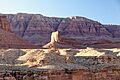
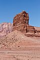
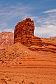
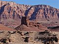
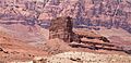
Cathedral Rock is a magnificent, towering rock formation that reaches about 3,942 feet (1,202 meters) high. It is located in the beautiful Glen Canyon National Recreation Area in northern Arizona, USA. This impressive natural landmark stands proudly in Coconino County, not far from the famous Navajo Bridge. It rises over 400 feet (122 meters) above the land around it, making it a truly unforgettable sight. You can easily spot Cathedral Rock from U.S. Route 89A as you travel through Marble Canyon. People started calling this amazing place "Cathedral Rock" before the year 1900, and its name was officially recognized in 1969 by the U.S. Board on Geographic Names, which is the group responsible for naming places in the United States.
The Story of Cathedral Rock: How It Was Formed
Cathedral Rock is part of the vast Colorado Plateau, a huge area of high desert in the western United States. This amazing rock formation is what scientists call an "erosional remnant." This means it's a piece of rock that has been left behind after wind and water slowly wore away the softer rock around it over millions of years.
The rock itself is made of red sandstone, which comes from a geological layer called the Moenkopi Formation. This sandstone was formed a very long time ago, during a period in Earth's history known as the Triassic period. Imagine ancient deserts and rivers depositing sand that eventually turned into solid rock! On top of this sandstone, you'll find a harder layer called a Shinarump Conglomerate caprock. This caprock acts like a protective hat, helping to shield the softer sandstone underneath from erosion.
When rain falls on Cathedral Rock, the water flows off its sides. This "runoff" then travels a short distance to the east, eventually joining the mighty Colorado River.
Weather at Cathedral Rock: Hot Summers and Cool Winters
The area around Cathedral Rock experiences an arid climate, which means it's very dry. According to a system used by scientists to classify climates, this region has hot, extremely dry summers. Winters are quite chilly, but there's usually very little snow. If you want to know more about the typical weather, you can look at climate information for Page, Arizona, which is about 12 miles (19 kilometers) northeast of Cathedral Rock.
Gallery
-
-

South face
-
-
Cathedral Rock, with Vermilion Cliffs behind
-
-
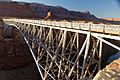
Cathedral Rock left of center (illuminated) above Navajo Bridge, Vermilion Cliffs National Monument further in the distance.
-