
Cave Dale facts for kids
Quick facts for kids Cave Dale |
|
|---|---|

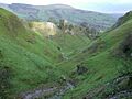
The view from the top of the steep section
|
|

Cave Dale
Location in Derbyshire
|
|
| Length | c.1.2 kilometres (0.75 mi) |
| Geography | |
| Location | Castleton, Derbyshire |
| Country | England |
Cave Dale (sometimes spelled Cavedale) is a special kind of valley in the Derbyshire Peak District, England. It's called a 'dry limestone valley' because it was carved by water long ago, but now there's no river flowing through it.
This amazing valley starts near the village of Castleton. Here, the sides of the valley are super steep, like tall walls, reaching over 50 meters (about 164 feet) high! As you walk away from Castleton, the valley gently rises for about 200 meters (218 yards). Then, it gets much steeper, leading to a fantastic spot where you can look down the valley. From here, you can see the old Peveril Castle and Lose Hill in the distance. After this viewpoint, the valley turns west and becomes flatter, eventually turning into a shallow dip in the land between Castleton and Chapel-en-le-Frith.
Contents
How Cave Dale Was Formed
Cave Dale was created a very long time ago by melting glaciers. Imagine huge sheets of ice melting and sending powerful streams of water. These streams carved a deep, narrow path through the soft limestone rock.
The Role of Underground Caves
After the glaciers were gone, the river that carved the valley found a way to flow underground. This left the valley dry on the surface, with many caves hidden beneath. Over time, some of these underground caves collapsed. This made the valley even deeper, especially at the Castleton end, where it looks like a deep gorge. About 200 years ago, the entrance to Cave Dale from Castleton even had a narrow natural arch, which was a leftover piece from one of these collapses.
Rocks and Cliffs in the Valley
If you look closely at the lower parts of the valley, you'll see lots of loose rocks and stones called scree. These broke off the higher limestone cliffs because of frost and ice. About halfway up the valley, there's also a special type of rock called basaltic lava. This rock came from volcanoes long, long ago and has a few small columns.
Exploring Cave Dale
A special path called a bridleway runs all the way through Cave Dale. This path is part of the Limestone Way, a long walking trail that stretches 80 kilometers (about 50 miles) from Castleton to Rocester in Staffordshire.

You can enter Cave Dale through a narrow, rocky opening right from the center of Castleton. As you walk in, you'll see Peveril Castle high up on the steep western side. The Normans, who built the castle, chose this spot because the steep sides of Cave Dale offered a natural defense and a great place to keep watch.
Hidden Wonders Beneath the Valley
The famous Peak Cavern has many chambers and caves that run directly underneath Cave Dale. Any small streams or rainwater in Cave Dale quickly disappear into cracks in the limestone, flowing down into these hidden caverns below. You can also spot shiny mineral veins within the limestone walls of the dale.
Rock Climbing and Nature
The tall cliffs at the northern end of Cave Dale are popular with rock climbers. There are several challenging climbing routes here. You might also find small caves or old lead mines built into the limestone walls. One of these is larger than the others, but it has bars to prevent people from entering.
The steep, north-facing grassy slopes of Cave Dale are often damp and rich in tiny plants called bryophytes. You'll mostly see oat grass and sheep's fescue growing here. On ledges in the dale, a plant called lesser meadow-rue grows widely.
Old Mines in the Area
At the very end of Cave Dale, where it blends into the open land between Castleton and Peak Forest, you can find the remains of several old lead mines. The Hazard Mine was one of the biggest in the area. Miners dug out over 5,000 tonnes of lead ore from this mine, and its main shaft goes down an incredible 700 feet (about 213 meters)! Another mine, the Hollandtwine Mine, is about 250 meters (273 yards) to the east. Water from both these mines used to drain directly into Peak Cavern.
Cave Dale in Movies
Cave Dale has even been featured in movies! You can see its beautiful scenery in the film The Princess Bride (1987) and The Other Boleyn Girl (2008).
Images for kids
-
The view from the top of the steep section
-
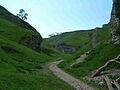
The northern part of Cave Dale near Castleton
