Cerro Blanco (volcano) facts for kids
Quick facts for kids Cerro Blanco |
|
|---|---|

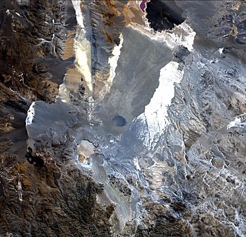
Satellite image of Cerro Blanco volcano. The black area on the upper edge is Carachipampa volcano. Cerro Blanco caldera is located slightly left and below the centre of the image and is the grey-yellow area. Top of image is to the north-northeast.
|
|
| Highest point | |
| Elevation | 4,670 m (15,320 ft) |
| Listing | List of volcanoes in Argentina |
| Naming | |
| English translation | White Hill |
| Language of name | Spanish |
| Geography | |
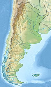
| Location | Catamarca Province, Argentina |
| Parent range | Andes |
| Geology | |
| Age of rock | Holocene |
| Mountain type | Caldera |
| Volcanic belt | Central Volcanic Zone |
| Last eruption | 2,300 ± 160 BCE |
Contents
Cerro Blanco (which means "White Hill" in Spanish) is a special type of volcano called a caldera. It's located in the Andes mountains in Catamarca Province, Argentina. This volcano is part of the Central Volcanic Zone of the Andes. It sits in a low area at about 4,670 meters (15,318 feet) high.
Cerro Blanco has been active for millions of years. Its biggest known eruption happened around 4,200 years ago. This eruption was huge, rated as a VEI-7 (Volcanic Explosivity Index 7). It created the main caldera we see today and spread a lot of volcanic ash and rock. Since then, the volcano has been mostly quiet.
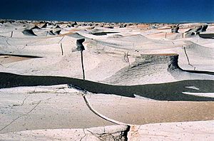
This area is also famous for its giant "ripple marks." These are like huge waves in the ground, formed by strong winds moving sand and gravel. Some of these ripples are over 2 meters (7.5 feet) tall! Scientists even compare them to ripple marks found on Mars.
What is Cerro Blanco?
A Volcano's Special Shape
Cerro Blanco is not a typical cone-shaped volcano. It's a caldera, which is a large bowl-shaped hollow. This forms when a volcano erupts so much magma that its top collapses inward. Cerro Blanco actually has several of these collapsed areas, along with some lava domes (mounds of thick, slow-moving lava).
The main Cerro Blanco caldera is about 4 to 6 kilometers (2.5 to 3.7 miles) wide. Its walls can be up to 300 meters (980 feet) high. The ground inside the caldera is mostly covered by volcanic rock and ash. There are also some white mineral deposits from hot water activity.
Giant Ripple Marks and Wind-Sculpted Rocks
One of the most amazing things about Cerro Blanco is its unique landscape, shaped by wind. The area has some of the largest ripple marks on Earth. These "waves" in the ground are made of gravel and sand. They can be up to 2.3 meters (7.5 feet) high and 43 meters (141 feet) long! Strong winds constantly move these ripples.
The wind also carves other cool shapes into the volcanic rock. These include "yardangs" and "hoodoos."
- Yardangs are long, sculpted ridges of rock.
- Hoodoos are tall, thin spires of rock.
These formations are especially impressive in an area called the Campo de Piedra Pómez. This area is so special that it's now a protected area in Catamarca Province.
Where is Cerro Blanco Located?
Cerro Blanco is in the southern part of the Argentine Puna region. This is a high plateau in the Andes mountains. It's on the border between two departments in Catamarca Province: Antofagasta de la Sierra and Tinogasta.
A road, Provincial Route 34, passes by Cerro Blanco. This road connects the towns of Fiambalá and Antofagasta de la Sierra. The area around the volcano has trails and some old mining sites.
How Cerro Blanco Formed
Earth's Moving Plates
Cerro Blanco's volcanoes are formed because of how Earth's giant plates move. The Nazca Plate is sliding underneath the South America Plate. This process, called subduction, creates a lot of heat and pressure. This leads to volcanoes forming in the Andes mountains.
Cerro Blanco is part of the Central Volcanic Zone (CVZ), which is one of three main volcanic areas in the Andes. The CVZ is known for its large fields of volcanic ash and rock, and many calderas.
A Long History of Eruptions
Volcanic activity in this part of the Andes started about 8 million years ago. Cerro Blanco itself has been active for at least the last 750,000 years.
One major eruption happened about 73,000 years ago. It created a large layer of volcanic rock called the Campo de la Piedra Pómez Ignimbrite.
The Big Eruption 4,200 Years Ago
The most famous eruption of Cerro Blanco happened around 4,200 years ago. This was a huge event, one of the biggest known eruptions in the Central Andes.
- It created a tall column of ash and gas, reaching about 27 kilometers (17 miles) high.
- Strong winds carried most of the ash to the east-southeast. It covered an area of about 500,000 square kilometers (193,000 square miles).
- This eruption also produced fast-moving currents of hot gas and volcanic rock called pyroclastic flows. These flows traveled up to 35 kilometers (22 miles) from the volcano.
- The eruption was so powerful that the ground above the magma chamber collapsed. This created the main Cerro Blanco caldera we see today.
Scientists believe this eruption was a VEI-7 event. This means it was incredibly powerful, similar to some of the largest volcanic eruptions in history. The ash from this eruption has even helped archaeologists date ancient sites in the region.
Is Cerro Blanco Still Active?
Even though there haven't been any recorded eruptions in recent history, Cerro Blanco is still considered active.
- Earthquakes: Small earthquakes have been detected near the volcano.
- Hot Spots: There are areas on the caldera floor where the ground is hot. Gases like carbon dioxide and water vapor escape from cracks in the ground, called fumaroles.
- Hot Springs: South of the volcano, there's another area with hot springs and bubbling pools. These are signs of heat coming from deep underground.
- Ground Movement: Satellite images show that the ground at Cerro Blanco has been slowly sinking. This could be due to the magma system cooling or other underground changes.
The Argentinian Mining and Geological Service ranks Cerro Blanco as one of the more hazardous volcanoes in Argentina. A future large eruption could send ash far away, affecting air travel. Pyroclastic flows could also reach nearby communities to the south.
Researching Cerro Blanco
Scientists have been studying the Cerro Blanco region for a long time. In the early 2000s, satellite images showed the caldera was changing shape, which sparked more interest. Researchers have worked to link layers of ash found in the region to specific eruptions from Cerro Blanco. The discovery of the huge 4,200-year-old eruption in the 2010s led to even more scientific studies.
See also
 In Spanish: Volcán Robledo para niños
- Cerro Torta
 | Bessie Coleman |
 | Spann Watson |
 | Jill E. Brown |
 | Sherman W. White |


