
Cerro de Chipinque facts for kids
Quick facts for kids Cerro de Chipinque |
|
|---|---|

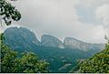
Cerro de Chipinque seen from Monterrey
|
|
| Highest point | |
| Elevation | 2,229 m (7,313 ft) |
| Geography | |
|
Lua error in Module:Location_map at line 420: attempt to index field 'wikibase' (a nil value).
|
|
| Location | San Pedro Garza García, Monterrey, Santa Catarina; Nuevo León |
| Country | |
| Parent range | Sierra Madre Oriental |
| Geology | |
| Mountain type | Mountain |
Cerro de Chipinque is a cool mountain in Mexico. It's located near the cities of San Pedro Garza García, Monterrey, and Santa Catarina in the state of Nuevo León. This mountain is part of the big Sierra Madre Oriental mountain range. It's also inside the beautiful Cumbres de Monterrey National Park.
Its highest point is 2,229 meters (about 7,313 feet) above sea level. Many people in the Monterrey area see it as a special symbol. Around the mountain, you'll find valleys like Santa Catarina and San Pedro. There are also canyons such as Ballesteros and La Huasteca. The "Parque ecológico Chipinque" (Chipinque Ecological Park) is on the northern side of the mountain. The mountain's name might come from the Nahuatl word "chichipinqui," which means "small rain." It could also be named after an old indigenous chief.
-
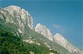
La eme seen from the plateau of Chipinque Park.
-
La eme seen from a hotel at the plateau.
-
El Pinar seen from Chipinque


Contents
Discovering Chipinque
Even though people knew about this area's beauty for a long time, it only became an Ecological Park in 1992. This happened when a group of people, including the government of Nuevo León and private organizations, officially created it. Chipinque was also a must-visit place for anyone interested in biology and ecology. Its unique northern habitat and many different kinds of plants and animals made it very special.
The main goal of this park is to protect the many different living things that call it home. They do this by making sure natural resources are used carefully. Chipinque is open every day of the year, from 6 AM to 8 PM. Most of the park is open for everyone to explore. However, you need special permission and a guide to climb some of the very highest peaks. The park has 22 forest rangers who help protect the area.
Where is Chipinque?
Cerro de Chipinque is located in the Sierra Madre Oriental mountain range. It is part of the Cumbres de Monterrey National Park. The park covers a large area of 1,625 hectares. However, only about 300 of these hectares are open for visitors to enjoy.
The mountain's height ranges from 800 meters to about 2,200 meters above sea level. The very tallest peak is called Copete de las Águilas. This Spanish name means "crest of the eagles." The main ridge of the mountain stretches for about 17 kilometers (about 10.5 miles).
Plant Life

This area is mostly known for its large coniferous forests. These forests are full of trees that have needles and cones. You can find many interesting plants here. Some examples include different types of Agave plants, like Agave americana. There are also beautiful flowers such as Asclepias (milkweed) and Ipomoea (morning glory).
You might also spot ferns growing in the shade. Other plants include Juniperus flaccida (a type of juniper tree) and Opuntia (prickly pear cactus). The forests also have Pinus pseudostrobus (a kind of pine tree) and various types of oak trees, like Quercus canbyi.
Animal Life
The animals in this area are mainly large mammals and birds. You might see Coyotes, Wildcats, and Coatis roaming around. White-tailed deer are also common. Sometimes, even the grey wolf can be found here.
For bird watchers, there are many species to spot. These include the Red-tailed hawk, Turkey vulture, and Wild turkey. Smaller birds like the Mountain pygmy owl and Bronzed cowbird also live here. The colorful Blue-capped motmot is another beautiful bird you might see. The park is also famous for its many different kinds of butterfly species.
Climate and Environment
The average temperature in Chipinque is about 20 °C (68 °F). The area gets about 860 millimeters (34 inches) of rain each year. This region is mainly a subhumid temperate forest. It also has submontane scrubland areas. The forests are mostly made up of pine and oak trees.
See also
 In Spanish: Cerro de Chipinque para niños
