Chefornak, Alaska facts for kids
Quick facts for kids
Chefornak
Cevvʼarneq / Caputnguaq
|
|
|---|---|
 |
|
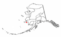
Location of Chefornak, Alaska
|
|
| Country | United States |
| State | Alaska |
| Census Area | Bethel |
| Incorporated | 1974 |
| Area | |
| • Total | 5.99 sq mi (15.51 km2) |
| • Land | 5.24 sq mi (13.56 km2) |
| • Water | 0.75 sq mi (1.95 km2) |
| Elevation | 0 ft (0 m) |
| Population
(2020)
|
|
| • Total | 506 |
| • Density | 96.64/sq mi (37.31/km2) |
| Time zone | UTC-9 (Alaska (AKST)) |
| • Summer (DST) | UTC-8 (AKDT) |
| ZIP code |
99561
|
| Area code | 907 |
| FIPS code | 02-12680 |
| GNIS feature ID | 1400188 |
Chefornak (which means Cevvʼarneq in the local Yup'ik language) is a small city in Alaska, United States. It is located in the Bethel Census Area. In 2010, 418 people lived there. By 2020, the population had grown to 506 people.
Contents
Where is Chefornak?
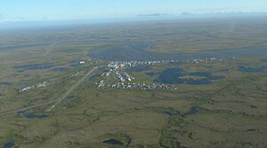
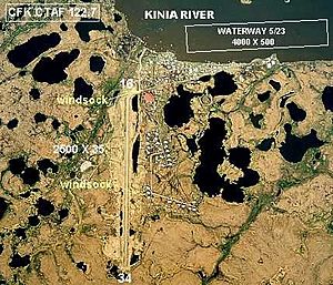
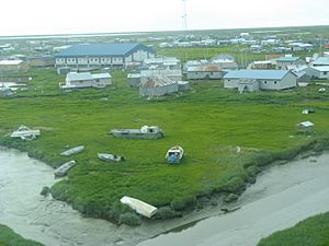
Chefornak is found at 60.159070 degrees north and -164.269437 degrees west. It sits on the south bank of the Kinia River. This river flows into the Etolin Strait, which is part of the Bering Sea. The city is about 16 miles (26 km) upriver from where the Kinia River meets the sea.
The city is also located inside the Yukon Delta National Wildlife Refuge. This is a large protected area for wildlife.
According to the United States Census Bureau, Chefornak covers a total area of about 6.4 square miles (16.6 square kilometers). Most of this area is land, with a small part being water.
Local Landscape and Rocks
Chefornak is in a special place where the cold, flat land called tundra meets the Bering Sea. This area has been shaped by ancient volcanoes, which makes the local landscape very interesting.
You can see an extinct volcano called Tern Mountain in the distance to the south. An extinct volcano is one that is no longer active and is not expected to erupt again. Large, blocky rocks, known as igneous rocks, are common here. Igneous rocks are formed when hot, melted rock cools and hardens.
The Kinia River, also known as Urrsukvaaq, is very important to the people of Chefornak. Its many smaller streams help people travel by boat to places where they hunt and fish. However, the river can also cause problems like flooding and land wearing away (erosion).
Who Lives in Chefornak?
| Historical population | |||
|---|---|---|---|
| Census | Pop. | %± | |
| 1950 | 106 | — | |
| 1960 | 133 | 25.5% | |
| 1970 | 146 | 9.8% | |
| 1980 | 230 | 57.5% | |
| 1990 | 320 | 39.1% | |
| 2000 | 394 | 23.1% | |
| 2010 | 418 | 6.1% | |
| 2020 | 506 | 21.1% | |
| U.S. Decennial Census | |||
Chefornak first appeared on the U.S. Census in 1950. At that time, it was a small village. It officially became a city in 1974.
In 2000, there were 394 people living in Chefornak. Most of the people were Alaska Native, making up about 93.4% of the population. A small number of people were White or from two or more races.
Many households in Chefornak have children. In 2000, about 60% of households had children under 18. The average household had about five people. The median age of people living in Chefornak was 21 years old. This means that half the population was younger than 21, and half was older.
Cultural Activities
Yup'ik dancing is a very popular activity in Chefornak. The local high school has a Yup'ik Dance Team. This team often visits other villages to perform at special events like feasts and festivals.
Chefornak sometimes hosts its own dance festival in the spring. Many people from Chefornak also travel to the large Cama-i festival in Bethel. This festival is a chance for different villages to show off their dances and see performances from other areas.
Living Off the Land
Many people in Chefornak live a subsistence lifestyle. This means they get a lot of their food directly from nature. They continue to hunt and gather, just like their ancestors did. This way of life is adapted to the local environment.
Important foods include different kinds of fish, such as halibut, salmon, and herring. These fish are often dried, similar to jerky, and eaten later. The Alaska blackfish is also a key part of their diet. It can be caught in the river all year round.
Residents also gather berries like salmonberries (cloudberries), black berries (crowberries), and blueberries (bog bilberries). These berries are used to make akutaq, a special whipped dessert. Other native foods gathered include mousefood, Labrador tea, and greens like sourdock.
Buildings in the Village
Besides homes, Chefornak has several important public buildings:
- Chefarnrmute, Inc., which is the village's local business corporation.
- Avugiak's Store, another local shop.
- The post office, for mail services.
- A town hall, which also serves as a bingo hall.
- The school building, which houses both the elementary and high school.
- The Old School, which used to be run by the B.I.A..
- St. Catherine of Siena Catholic Church.
- The power plant, which provides electricity to the village.
Education in Chefornak
The Lower Kuskokwim School District runs the schools in Chefornak. There are two schools in one building: Chaputnguak School for elementary students and Amaqigciq School for high school students.
The Chaputnguak School is named after Chaputnguak. This was the original name for Chefornak. It is a Yup'ik word that means something blocking a path. The Amaqigciq School is named after Alexie Amaqigciq. He was a Yup'ik elder who chose the village site and was the first person to live in Chefornak.
How to Get Around
Most people travel to Chefornak by small airplane. In the winter, people can also use a snowmobile to reach the village. Goods and mail arrive by plane. During the summer, supplies can also be brought up the Kinia River by barge (a flat-bottomed boat).
Chefornak's airport has been moved further away from the village. This was done because it was too close to the school. The new airport is now open and in use. Within the village itself, people get around using four-wheelers, bicycles, snow machines, or by walking.
Notable People
See also
 In Spanish: Chefornak (Alaska) para niños
 | Laphonza Butler |
 | Daisy Bates |
 | Elizabeth Piper Ensley |


