Chibi, Hubei facts for kids
Quick facts for kids
Chibi
赤壁市
|
|
|---|---|
|
County-level city
|
|

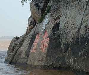
Engravings on a cliffside near Chibi City
|
|
| Country | People's Republic of China |
| Province | Hubei |
| Prefecture-level city | Xianning |
| Area | |
| • County-level city | 1,723 km2 (665 sq mi) |
| • Urban | 51.20 km2 (19.77 sq mi) |
| Elevation | 67 m (221 ft) |
| Population
(2010)
|
|
| • County-level city | 478,410 |
| • Density | 277.66/km2 (719.14/sq mi) |
| • Urban | 252,600 |
| Time zone | UTC+8 (China Standard) |
| Area code(s) | 437300 |
Chibi (Chinese: 赤壁; pinyin: Chìbì) is a city in southeastern Hubei province, China. It's like the "South Gate of Hubei" because it's located north of Wuhan and south of Yueyang. The city is managed by Xianning, which is a larger city area.
Chibi was known as Puqi (Chinese: 蒲圻; pinyin: Púqí) until 1998. Its name was changed to "Chibi" because it's believed to be the place where the famous Battle of Chibi happened a very long time ago, around 208 or 209 CE. The city covers an area of about 1,723 square kilometers and had a population of over 500,000 people in 2006.
People of Chibi
Over the years, the number of people living in Chibi has grown a lot. For example, in 1908, there were about 185,000 people. By 1964, the population had increased to nearly 250,000.
In 1982, most of the people in Chibi were Han Chinese, making up about 99.45% of the population. There were also smaller groups of other ethnic minorities. These included the Hui people, Miao people, Dong people, Tujia people, Zhuang people, and Manchu people, among others.
How Chibi is Governed
The way Chibi is organized into different areas has changed over many centuries. It started with a system of "townships" during the Song dynasty and Yuan dynasty. Later, in the Ming dynasty, it used a "capital system."
Today, Chibi is divided into several main areas. It has three subdistricts, which are like smaller city neighborhoods. It also has ten towns and one township, which are larger rural areas. In total, Chibi oversees 152 village committees and many smaller village groups.
Here are some of the main areas:
- Subdistricts:
* Puqi Subdistrict (蒲圻街道) * Chimagang Subdistrict (赤马港街道) * Lushuihu Subdistrict (陆水湖街道)
- Towns:
* Xindian (新店镇) * Zhaoliqiao (赵李桥镇) * Cha'anling (茶庵岭镇) * Chebu (车埠镇) * Chibi Town (赤壁镇) * Liushanhu (柳山湖镇) * Shenshan (神山镇) * Zhonghuopu (中伙铺镇) * Guantangyi (官塘驿镇) * (黄盖湖镇)
- Township:
There are also other important areas like industrial parks and special development zones.
Weather in Chibi
Chibi has a climate that changes with the seasons. You can see details about the average temperatures, rainfall, and sunshine in the table below.
| Climate data for Chibi (1991–2020 normals, extremes 1981–2010) | |||||||||||||
|---|---|---|---|---|---|---|---|---|---|---|---|---|---|
| Month | Jan | Feb | Mar | Apr | May | Jun | Jul | Aug | Sep | Oct | Nov | Dec | Year |
| Record high °C (°F) | 24.6 (76.3) |
29.5 (85.1) |
34.4 (93.9) |
36.0 (96.8) |
36.6 (97.9) |
38.6 (101.5) |
41.2 (106.2) |
41.3 (106.3) |
39.2 (102.6) |
36.2 (97.2) |
32.7 (90.9) |
25.7 (78.3) |
41.3 (106.3) |
| Mean daily maximum °C (°F) | 9.1 (48.4) |
12.2 (54.0) |
16.9 (62.4) |
23.4 (74.1) |
27.7 (81.9) |
30.7 (87.3) |
33.8 (92.8) |
33.2 (91.8) |
29.2 (84.6) |
23.9 (75.0) |
18.0 (64.4) |
11.9 (53.4) |
22.5 (72.5) |
| Daily mean °C (°F) | 5.0 (41.0) |
7.7 (45.9) |
12.0 (53.6) |
18.1 (64.6) |
22.8 (73.0) |
26.3 (79.3) |
29.5 (85.1) |
28.7 (83.7) |
24.5 (76.1) |
18.9 (66.0) |
12.9 (55.2) |
7.2 (45.0) |
17.8 (64.0) |
| Mean daily minimum °C (°F) | 2.1 (35.8) |
4.5 (40.1) |
8.4 (47.1) |
14.1 (57.4) |
18.9 (66.0) |
22.9 (73.2) |
26.1 (79.0) |
25.4 (77.7) |
21.0 (69.8) |
15.4 (59.7) |
9.4 (48.9) |
4.1 (39.4) |
14.4 (57.8) |
| Record low °C (°F) | −6.5 (20.3) |
−7.5 (18.5) |
−3.0 (26.6) |
3.1 (37.6) |
9.0 (48.2) |
12.6 (54.7) |
18.8 (65.8) |
16.8 (62.2) |
11.7 (53.1) |
2.8 (37.0) |
−1.9 (28.6) |
−10.0 (14.0) |
−10.0 (14.0) |
| Average precipitation mm (inches) | 72.9 (2.87) |
92.0 (3.62) |
133.6 (5.26) |
191.8 (7.55) |
204.0 (8.03) |
240.0 (9.45) |
225.0 (8.86) |
142.9 (5.63) |
87.2 (3.43) |
82.4 (3.24) |
79.1 (3.11) |
46.7 (1.84) |
1,597.6 (62.89) |
| Average precipitation days (≥ 0.1 mm) | 12.0 | 12.5 | 15.5 | 13.8 | 14.0 | 14.2 | 13.2 | 11.9 | 9.4 | 10.2 | 10.5 | 9.4 | 146.6 |
| Average snowy days | 4.6 | 2.4 | 0.7 | 0 | 0 | 0 | 0 | 0 | 0 | 0 | 0.2 | 1.4 | 9.3 |
| Average relative humidity (%) | 79 | 78 | 78 | 76 | 77 | 80 | 75 | 78 | 78 | 77 | 78 | 76 | 78 |
| Mean monthly sunshine hours | 84.3 | 84.9 | 105.8 | 131.5 | 148.3 | 143.7 | 201.6 | 192.1 | 148.2 | 136.7 | 121.4 | 111.2 | 1,609.7 |
| Percent possible sunshine | 26 | 27 | 28 | 34 | 35 | 34 | 47 | 47 | 40 | 39 | 38 | 35 | 36 |
| Source: China Meteorological Administration | |||||||||||||
Historic Sites
One interesting historic place in Chibi is Yangloudong (羊楼洞). This area was once a very important center for making and trading tea. It's located in the town of Zhaoliqiao, close to the border with Hunan province. Yangloudong is about 26 kilometers southwest of downtown Chibi.
 | Frances Mary Albrier |
 | Whitney Young |
 | Muhammad Ali |


