
Chilkoot Trail and Dyea Site facts for kids
|
Chilkoot Trail and Dyea Site
|
|
|
U.S. Historic district
Contributing property |
|

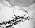
Miners climbing Chilkoot
|
|

Location in Alaska
|
|
| Nearest city | Skagway, Alaska |
|---|---|
| Area | 11,882 acres (4,808 ha) |
| Built | 1897 |
| Part of | Klondike Gold Rush National Historical Park (ID76002189) |
| NRHP reference No. | 75002120 |
Quick facts for kids Significant dates |
|
| Added to NRHP | April 14, 1975 |
| Designated NHLD | June 16, 1978 |
| Designated CP | June 30, 1976 |
The Chilkoot Trail and Dyea Site are two very important places in Alaska's history. They are part of the Klondike Gold Rush National Historical Park. This park helps protect old buildings and areas connected to the exciting Klondike Gold Rush.
Imagine a time when thousands of people rushed to find gold! Between 1897 and 1899, this trail and the town of Dyea were buzzing with gold seekers. By 1905, most of the buildings were gone. Today, both the trail and the town site are protected as part of the National Park.
Contents
Discovering Dyea: A Gold Rush Town
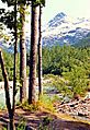
Dyea is now a ghost town. It sits where the Taiya River meets the Taiya Inlet, near Skagway, Alaska. During the Klondike Gold Rush, gold seekers arrived at Dyea's port. From there, they started their long journey to the gold fields. These gold fields were around Dawson City, Yukon, about 800 kilometers (500 miles) away.
The gold seekers used the Chilkoot Trail. This trail was an old trade route used by the Tlingit people. It went over the Coast Mountains. Dyea's port had shallow water, which made it harder for big ships. The nearby town of Skagway, Alaska had deeper water. Dyea was eventually left empty. This happened when a new railroad chose the White Pass Trail from Skagway instead of the Chilkoot Trail.
The Chilkoot Trail: A Path to Gold
The Chilkoot Trail is about 53 kilometers (33 miles) long. It goes through the rugged Coast Mountains. The trail starts in Dyea and ends at Bennett, British Columbia, in Canada. For a long time, the Tlingit First Nations used this trail. It was a vital trade route for them to get resources from inland areas.
Over time, more American settlers and the Hudson's Bay Company arrived. This changed the traditional Tlingit trading system. The Chilkoot Trail slowly became used by explorers and people looking for gold.
Why the Chilkoot Trail Became Famous
The Klondike Gold Rush completely changed the Chilkoot Trail. It became a major way for people to travel into Canada's interior. The main gold rush area was around Dawson City, Yukon, near the Yukon River. There were several land routes to get there. The Chilkoot Trail was the most direct and cheapest option. Because of this, it quickly became the most popular route.
However, its popularity didn't last forever. A new railway was built from Skagway. This railway offered an easier way to travel. Soon, the Chilkoot Trail was no longer used by many people and was eventually abandoned.
Images for kids
-
Chilkoot Pass during gold rush. March–April 1898
-

Briefing at Sheep Camp
-

Dyea, head of Lynn Canal
-

Between Finnegan's Point and Canyon City
-

Chilkoot Pass in June
-

Lake Lindeman in the early summer
-
Pleasant Camp
-
Happy Camp in the early season, 2004
-
Lake Lindeman campground, 2004
-
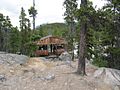
Bare Loon Lake Camp cooking shelter 2016
-

Bear track, 2004


