Chimney Rock (Jackson Butte) facts for kids
Quick facts for kids Chimney Rock |
|
|---|---|
| Jackson Butte | |
.jpg)
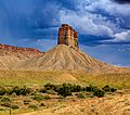
Southwest aspect
|
|
| Highest point | |
| Elevation | 6,110 ft (1,860 m) |
| Prominence | 690 ft (210 m) |
| Isolation | 3.71 mi (5.97 km) |
| Parent peak | West Ute Mesa (7,088 ft) |
| Geography | |

Chimney Rock
Location in Colorado

Chimney Rock
Location in the United States
|
|
| Location | Montezuma County, Colorado, U.S. |
| Parent range | Colorado Plateau |
| Topo map | USGS Tanner Mesa |
| Geology | |
| Age of rock | Cretaceous |
| Type of rock | Point Lookout Sandstone |
| Climbing | |
| Easiest route | class 5.x climbing |
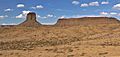
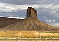
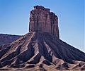
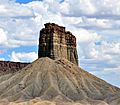
Chimney Rock is a tall, natural rock pillar in southwest Colorado. It stands 6,110 feet (about 1,860 meters) high. You can find it inside the Ute Mountain Tribal Park in Montezuma County. This amazing landmark is about one mile southeast of where U.S. Route 491 and US 160 meet. It rises 900 feet above the Mancos River Valley.
Chimney Rock is also known as Jackson Butte. It was named after William Henry Jackson (1843–1942). He was a famous photographer and explorer. Jackson took many pictures of the American West. He visited this area during the Hayden Survey. He was the first person to photograph the ancient cliff dwellings in the Mesa Verde region of the Four Corners area.
The Amazing Geology of Chimney Rock
Chimney Rock is part of the Colorado Plateau. It is made of a type of rock called Cretaceous Point Lookout Sandstone. This sandstone is the oldest of the three rock layers that form the Mesaverde Group. The Mesaverde Group is very common in the Mesa Verde region.
The strong, cliff-forming Point Lookout Sandstone sits on top of a softer rock layer. This softer layer is called Mancos Shale. Rainwater that runs off Chimney Rock flows into the Mancos River watershed.
Gallery
-
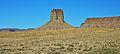
Northwest aspect
-
-
-
-
-