
Chimney Rock (Utah) facts for kids
Quick facts for kids Chimney Rock |
|
|---|---|

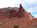
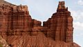
Chimney Rock, south-southwest aspect
|
|
| Highest point | |
| Elevation | 6,420 ft (1,960 m) |
| Prominence | 80 ft (24 m) |
| Isolation | 0.34 mi (0.55 km) |
| Parent peak | Mummy Cliff |
| Geography | |

Chimney Rock
Location in Utah

Chimney Rock
Location in the United States
|
|
| Location | Capitol Reef National Park Wayne County, Utah, US |
| Parent range | Colorado Plateau |
| Topo map | USGS Twin Rocks |
| Geology | |
| Age of rock | Triassic |
| Climbing | |
| Easiest route | closed to climbing |
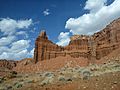
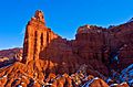
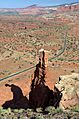
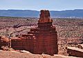
Chimney Rock is a tall, impressive rock formation in Capitol Reef National Park in Utah, United States. It stands 6,420 feet (1,960 meters) high! This amazing landmark is about 2.5 mi (4.0 km) northwest of the park's visitor center. It towers over 300 feet (90 meters) above Highway 24.
Chimney Rock is also 2.5 mi (4.0 km) northwest of another famous spot in the park, The Castle. Rain and snowmelt from Chimney Rock flow into the Colorado River. If you like hiking, there's a 3.5-mile loop trail called the Chimney Rock Trail. It takes you to a great view of Chimney Rock from above Mummy Cliffs.
Contents
How Chimney Rock Formed
Chimney Rock is a leftover piece of rock that has been shaped by wind and water over millions of years. It's mostly made of red sandstone from something called the Moenkopi Formation. On top, it has a harder layer called Shinarump Conglomerate, which is part of the Chinle Formation.
The Moenkopi Formation rocks are super old, about 245 million years old! They formed during a time called the Triassic Period. Back then, this area was very different.
Long after these rocks were laid down, the whole Colorado Plateau slowly lifted up. Usually, the rock layers stay flat, but Capitol Reef is special. It has a huge bend in the rock layers called the Waterpocket Fold. This giant fold formed between 50 and 70 million years ago. It's like a wrinkle in the Earth's crust!
Visiting Chimney Rock
The best times to visit Chimney Rock are in the spring and fall. The weather is usually just right for exploring the park and seeing the amazing rock formations.
Weather in Capitol Reef
Capitol Reef National Park has a Cold semi-arid climate. This means it's a desert climate, but it can get quite cold in winter. The coldest month usually has an average temperature below 32 °F (0 °C). Most of the rain and snow falls in spring and summer.
The park gets less than 10 inches (250 millimeters) of rain each year. Snowfall in winter is usually light. Even though it's a desert, temperatures can change a lot between day and night.
| Climate data for Capitol Reef Visitor Center, elevation 5,653 ft (1,723 m), 1981-2010 normals, extremes 1981-2019 | |||||||||||||
|---|---|---|---|---|---|---|---|---|---|---|---|---|---|
| Month | Jan | Feb | Mar | Apr | May | Jun | Jul | Aug | Sep | Oct | Nov | Dec | Year |
| Record high °F (°C) | 58.6 (14.8) |
68.3 (20.2) |
78.3 (25.7) |
84.4 (29.1) |
94.6 (34.8) |
100.2 (37.9) |
100.8 (38.2) |
97.9 (36.6) |
95.4 (35.2) |
86.1 (30.1) |
70.4 (21.3) |
61.5 (16.4) |
100.8 (38.2) |
| Mean daily maximum °F (°C) | 40.6 (4.8) |
46.4 (8.0) |
54.7 (12.6) |
65.0 (18.3) |
74.5 (23.6) |
85.3 (29.6) |
90.4 (32.4) |
87.9 (31.1) |
80.2 (26.8) |
66.1 (18.9) |
51.3 (10.7) |
40.6 (4.8) |
65.3 (18.5) |
| Mean daily minimum °F (°C) | 17.8 (−7.9) |
22.7 (−5.2) |
30.2 (−1.0) |
36.2 (2.3) |
44.7 (7.1) |
53.1 (11.7) |
60.4 (15.8) |
58.5 (14.7) |
50.4 (10.2) |
39.0 (3.9) |
27.6 (−2.4) |
18.2 (−7.7) |
38.3 (3.5) |
| Record low °F (°C) | −4.2 (−20.1) |
−11.8 (−24.3) |
9.1 (−12.7) |
18.1 (−7.7) |
27.2 (−2.7) |
34.6 (1.4) |
42.4 (5.8) |
45.1 (7.3) |
29.9 (−1.2) |
11.7 (−11.3) |
8.0 (−13.3) |
−7.5 (−21.9) |
−11.8 (−24.3) |
| Average precipitation inches (mm) | 0.52 (13) |
0.34 (8.6) |
0.53 (13) |
0.47 (12) |
0.59 (15) |
0.47 (12) |
0.91 (23) |
1.20 (30) |
0.80 (20) |
0.98 (25) |
0.49 (12) |
0.32 (8.1) |
7.62 (194) |
| Average dew point °F (°C) | 17.3 (−8.2) |
20.8 (−6.2) |
23.0 (−5.0) |
24.5 (−4.2) |
29.1 (−1.6) |
32.0 (0.0) |
40.0 (4.4) |
41.8 (5.4) |
34.8 (1.6) |
28.2 (−2.1) |
21.9 (−5.6) |
17.5 (−8.1) |
27.6 (−2.4) |
| Source: PRISM | |||||||||||||
More Pictures of Chimney Rock
-
South aspect
-
-
Looking WNW at Chimney Rock, Hwy 24, and trailhead
-
-
From west


Images for kids
-
North aspect

