
The Castle (Utah) facts for kids
Quick facts for kids The Castle |
|
|---|---|

The Castle, south aspect
|
|
| Highest point | |
| Elevation | 6,387 ft (1,947 m) |
| Prominence | 327 ft (100 m) |
| Isolation | 0.52 mi (0.84 km) |
| Parent peak | Peak 6700 |
| Geography | |

The Castle
Location in Utah

The Castle
Location in the United States
|
|
| Location | Capitol Reef National Park Wayne County, Utah, US |
| Parent range | Colorado Plateau |
| Topo map | USGS Twin Rocks |
| Geology | |
| Age of rock | Triassic |
| Type of rock | Wingate Sandstone |
| Climbing | |
| Easiest route | class 5+ climbing |
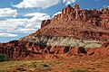
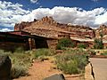
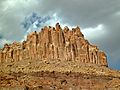
The Castle is a cool mountain peak in Capitol Reef National Park in Utah, United States. It stands tall at 6,387 feet (1,947 meters) high! This amazing landmark is super close to the park's visitor center, just about half a mile north. It rises almost 800 feet (240 meters) above the visitor center and Highway 24. Rainwater that falls on The Castle flows into streams that eventually join the Fremont River.
How The Castle Was Formed: Geology Facts
The very top part of The Castle is made of a strong rock called Wingate Sandstone. This rock is great for climbing because it has natural cracks, called joints. Scientists believe this sandstone formed about 200 million years ago.
Below the Wingate Sandstone, you can see a gray-green layer of rock called the Chinle Formation. This layer was made from volcanic ash about 225 million years ago. Even older is the Moenkopi Formation, which is about 245 million years old. All these rocks formed during a time called the Triassic period.
Many years after these layers of rock were laid down, the entire Colorado Plateau slowly lifted up. Usually, this lifting keeps the rock layers flat. But Capitol Reef is special because of something called the Waterpocket Fold. This is like a giant wrinkle in the Earth's crust, which formed between 50 and 70 million years ago.
Weather at The Castle: Climate Information
The best times to visit The Castle are in the spring and fall. The area has a Cold semi-arid climate, which means it's pretty dry and the coldest month has an average temperature below freezing (0 °C or 32 °F). Most of the rain and snow falls during spring and summer.
This desert area gets less than 10 inches (250 mm) of rain each year. Snowfall in winter is usually light, so it doesn't get too much snow.
| Climate data for Capitol Reef Visitor Center, elevation 5,653 ft (1,723 m), 1981-2010 normals, extremes 1981-2019 | |||||||||||||
|---|---|---|---|---|---|---|---|---|---|---|---|---|---|
| Month | Jan | Feb | Mar | Apr | May | Jun | Jul | Aug | Sep | Oct | Nov | Dec | Year |
| Record high °F (°C) | 58.6 (14.8) |
68.3 (20.2) |
78.3 (25.7) |
84.4 (29.1) |
94.6 (34.8) |
100.2 (37.9) |
100.8 (38.2) |
97.9 (36.6) |
95.4 (35.2) |
86.1 (30.1) |
70.4 (21.3) |
61.5 (16.4) |
100.8 (38.2) |
| Mean daily maximum °F (°C) | 40.6 (4.8) |
46.4 (8.0) |
54.7 (12.6) |
65.0 (18.3) |
74.5 (23.6) |
85.3 (29.6) |
90.4 (32.4) |
87.9 (31.1) |
80.2 (26.8) |
66.1 (18.9) |
51.3 (10.7) |
40.6 (4.8) |
65.3 (18.5) |
| Mean daily minimum °F (°C) | 17.8 (−7.9) |
22.7 (−5.2) |
30.2 (−1.0) |
36.2 (2.3) |
44.7 (7.1) |
53.1 (11.7) |
60.4 (15.8) |
58.5 (14.7) |
50.4 (10.2) |
39.0 (3.9) |
27.6 (−2.4) |
18.2 (−7.7) |
38.3 (3.5) |
| Record low °F (°C) | −4.2 (−20.1) |
−11.8 (−24.3) |
9.1 (−12.7) |
18.1 (−7.7) |
27.2 (−2.7) |
34.6 (1.4) |
42.4 (5.8) |
45.1 (7.3) |
29.9 (−1.2) |
11.7 (−11.3) |
8.0 (−13.3) |
−7.5 (−21.9) |
−11.8 (−24.3) |
| Average precipitation inches (mm) | 0.52 (13) |
0.34 (8.6) |
0.53 (13) |
0.47 (12) |
0.59 (15) |
0.47 (12) |
0.91 (23) |
1.20 (30) |
0.80 (20) |
0.98 (25) |
0.49 (12) |
0.32 (8.1) |
7.62 (194) |
| Average dew point °F (°C) | 17.3 (−8.2) |
20.8 (−6.2) |
23.0 (−5.0) |
24.5 (−4.2) |
29.1 (−1.6) |
32.0 (0.0) |
40.0 (4.4) |
41.8 (5.4) |
34.8 (1.6) |
28.2 (−2.1) |
21.9 (−5.6) |
17.5 (−8.1) |
27.6 (−2.4) |
| Source: PRISM | |||||||||||||
Images for kids
-
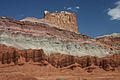
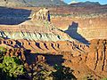
West side view. The grayish rock is Chinle Formation, and the brown layer at the bottom is Moenkopi.
-
-
-
-
The Castle casting a shadow at sunset, seen from Sunset Point.
-
-
-
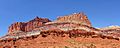
View of The Castle from the visitor center.
-
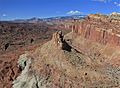
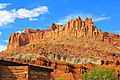
Looking down at The Castle from the east.


.jpg)


