
Chinook Peak facts for kids
Quick facts for kids Chinook Peak |
|
|---|---|

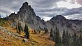
Chinook Peak seen from Chinook Pass
|
|
| Highest point | |
| Elevation | 6,904 ft (2,104 m) |
| Prominence | 504 ft (154 m) |
| Geography | |

Chinook Peak
Location in Washington (state)

Chinook Peak
Location in the United States
|
|
| Location | Mount Rainier National Park Pierce County, Washington, U.S. |
| Parent range | Cascades |
| Topo map | USGS White River Park |
| Climbing | |
| Easiest route | Scrambling class 3 |
Chinook Peak is a mountain that stands 6,904 feet (2,104 m) tall. It is located right on the eastern edge of Mount Rainier National Park. This peak also sits on the border between Pierce County and Yakima County in Washington state.
You can find Chinook Peak just north of Chinook Pass. It is part of the long chain of mountains called the Cascade Range. The closest taller mountain is Crystal Mountain, which is about 1.31 mi (2.11 km) to the north. Water from Chinook Peak flows into streams that feed the White River and Yakima River.
Mountain Weather
Chinook Peak is in a "marine west coast" climate zone. This means it gets a lot of moisture from the nearby Pacific Ocean. Most of the weather systems start over the Pacific. They then travel northeast towards the Cascade Mountains.
How Mountains Get Snow
When these weather systems hit the tall Cascade Mountains, the air is forced to rise. As the air goes higher, it cools down. This cooling causes the moisture in the air to turn into rain or snow. Because of this, the western side of the Cascades gets a lot of rain and especially heavy snowfall.
Seasons at Chinook Peak
During the winter, the weather around Chinook Peak is usually cloudy. But in the summer, high-pressure systems over the Pacific Ocean often bring clear skies. The snow here tends to be wet and heavy. This can sometimes lead to a higher risk of avalanches.
Images for kids
-
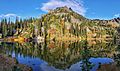
Southeast aspect reflected in Sheep Lake
-
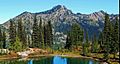
from a tarn along the Pacific Crest Trail near Naches Peak
-
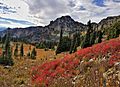
Chinook Peak, east aspect
-
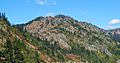
from Chinook Pass
-
Peak 6708 (left) and Chinook Peak from north


