
Cimarron, New Mexico facts for kids
Quick facts for kids
Cimarron, New Mexico
|
|
|---|---|
|
Village
|
|

Downtown Cimarron
|
|

Location of Cimarron, New Mexico
|
|

U.S. Census map
|
|

Cimarron, New Mexico
Location in the United States
|
|
| Country | United States |
| State | New Mexico |
| County | Colfax |
| Area | |
| • Total | 2.12 sq mi (5.48 km2) |
| • Land | 2.12 sq mi (5.48 km2) |
| • Water | 0.00 sq mi (0.00 km2) |
| Elevation | 6,421 ft (1,957 m) |
| Population
(2020)
|
|
| • Total | 792 |
| • Density | 374.11/sq mi (144.42/km2) |
| Time zone | UTC-7 (Mountain (MST)) |
| • Summer (DST) | UTC-6 (MDT) |
| ZIP code |
87714
|
| Area code(s) | 575 |
| FIPS code | 35-15440 |
| GNIS feature ID | 2413540 |
Cimarron is a small village in Colfax County, New Mexico. It sits on the eastern slopes of the Sangre de Cristo Mountains. In 2020, about 792 people lived there. This makes it the fourth largest town in Colfax County.
Cimarron is located along the Cimarron River. This river flows into the much longer Canadian River. The main part of the village is found along U.S. Route 64.
The village is surrounded by many large ranches. One famous ranch is Philmont Scout Ranch, a huge outdoor adventure camp for the Boy Scouts of America. Philmont is only four miles south of Cimarron. Other ranches nearby include the Chase Ranch and Ted Turner's Vermejo Park Ranch. You can also find the Elliott Barker State Wildlife Area and Cimarron Canyon State Park in the area.
Cimarron was one of the first places to use a four-day school week (Monday through Thursday). They started this in the early 1970s to save money on fuel and utilities. The local high school basketball team even won the New Mexico State Championship in 1979!
Contents
History of Cimarron

Cimarron is built on land that was once part of the huge Maxwell Land Grant. This was a very large area, about 1.7 million acres. In 1842, a fur trapper named Lucien B. Maxwell married Luz Beaubien. Her family owned the ranch, and Lucien later inherited it. He built a large house in 1858 where the village is today.
Maxwell also built the Aztec Mill in 1864. This old mill is now a museum called the Old Mill Museum. The museum shows how the mill worked. It also has old tools, pottery from Native Americans, and documents from the Maxwell Land Grant.
Cimarron officially became a village in 1859. Its name comes from a Spanish word that means "wild" or "unbroken." This word was used to describe a mustang (wild horse). Cimarron became the main town for Colfax County in 1872. It was an important stop on the Mountain Branch of the Santa Fe Trail, a famous old trading route. Later, in 1881, the county seat moved to Springer. Around this time, Lucien Maxwell sold his land. This led to a conflict called the Colfax County War, where many people lost their lives.
In 1905, a railway company built train tracks from Raton to Ute Park. These tracks were used to carry coal and also for daily passenger service. Ranchers used the trains to move their animals. During World War II, the tracks were taken up to reuse the steel for the war effort.
Soon after, more tracks were laid into Ponil Canyon. This was done by the Cimarron and Northwestern Railway Company. They used these tracks to transport timber (wood) from the mountains. This timber was then used to make railroad ties and supports for nearby coal mines.
Cimarron is still a lively place today. It benefits a lot from being close to Philmont Scout Ranch and from summer tourism.
The USS Cimarron, a naval ship, donated some of its important items to the village. This was because Cimarron is the closest village to the start of the Cimarron River. The ship's bell is now proudly displayed in front of Cimarron High School.
Geography and Climate
Cimarron is in the western part of Colfax County. It's on the north side of the Cimarron River, right where the river comes out of the Cimarron Range. U.S. Route 64 goes through the village. This road leads west about 23 miles to Eagle Nest and northeast about 40 miles to Raton. New Mexico State Road 58 goes east from Cimarron for about 19 miles to Interstate 25.
West of Cimarron, you can see the Palisades Sill. These are tall cliffs that stand around the Cimarron River.
Cimarron has a cool, dry climate. Summers have warm days and cool nights, often with thunderstorms. Winters are cold, and it sometimes snows a lot. The coldest temperature ever recorded in Cimarron was -35 degrees Fahrenheit.
| Climate data for CIMARRON 4 SW, NM (1991–2020 normals, extremes 1904–present) | |||||||||||||
|---|---|---|---|---|---|---|---|---|---|---|---|---|---|
| Month | Jan | Feb | Mar | Apr | May | Jun | Jul | Aug | Sep | Oct | Nov | Dec | Year |
| Record high °F (°C) | 81 (27) |
76 (24) |
81 (27) |
84 (29) |
92 (33) |
98 (37) |
101 (38) |
100 (38) |
98 (37) |
88 (31) |
81 (27) |
75 (24) |
101 (38) |
| Mean daily maximum °F (°C) | 47.6 (8.7) |
50.4 (10.2) |
58.2 (14.6) |
65.0 (18.3) |
73.2 (22.9) |
82.5 (28.1) |
84.3 (29.1) |
81.8 (27.7) |
77.2 (25.1) |
68.1 (20.1) |
56.3 (13.5) |
47.6 (8.7) |
66.0 (18.9) |
| Mean daily minimum °F (°C) | 18.1 (−7.7) |
19.5 (−6.9) |
25.8 (−3.4) |
31.8 (−0.1) |
40.3 (4.6) |
48.6 (9.2) |
52.8 (11.6) |
51.7 (10.9) |
44.7 (7.1) |
34.4 (1.3) |
24.3 (−4.3) |
17.4 (−8.1) |
34.1 (1.2) |
| Record low °F (°C) | −32 (−36) |
−24 (−31) |
−17 (−27) |
−2 (−19) |
17 (−8) |
25 (−4) |
40 (4) |
36 (2) |
16 (−9) |
−5 (−21) |
−18 (−28) |
−17 (−27) |
−32 (−36) |
| Average precipitation inches (mm) | 0.66 (17) |
0.57 (14) |
0.95 (24) |
1.51 (38) |
1.70 (43) |
1.74 (44) |
3.03 (77) |
3.11 (79) |
1.75 (44) |
1.22 (31) |
0.57 (14) |
0.43 (11) |
17.24 (438) |
| Average snowfall inches (cm) | 7.0 (18) |
7.1 (18) |
7.0 (18) |
5.0 (13) |
0.5 (1.3) |
0.0 (0.0) |
0.0 (0.0) |
0.0 (0.0) |
0.0 (0.0) |
2.1 (5.3) |
5.1 (13) |
6.2 (16) |
40.0 (102) |
| Average precipitation days (≥ 0.01 in) | 2.8 | 3.2 | 4.4 | 4.5 | 6.1 | 6.9 | 11.0 | 11.5 | 6.8 | 4.1 | 2.4 | 2.5 | 66.2 |
| Average snowy days (≥ 0.1 in) | 1.9 | 2.6 | 2.4 | 1.3 | 0.2 | 0.0 | 0.0 | 0.0 | 0.0 | 0.4 | 1.3 | 1.8 | 11.9 |
| Source: NOAA | |||||||||||||
Population and People
| Historical population | |||
|---|---|---|---|
| Census | Pop. | %± | |
| 1880 | 290 | — | |
| 1910 | 791 | — | |
| 1920 | 481 | −39.2% | |
| 1930 | 698 | 45.1% | |
| 1940 | 744 | 6.6% | |
| 1950 | 855 | 14.9% | |
| 1960 | 997 | 16.6% | |
| 1970 | 927 | −7.0% | |
| 1980 | 888 | −4.2% | |
| 1990 | 774 | −12.8% | |
| 2000 | 917 | 18.5% | |
| 2010 | 1,021 | 11.3% | |
| 2020 | 792 | −22.4% | |
| U.S. Decennial Census | |||
Cimarron covers about 2.12 square miles of land. According to the 2010 census, 1021 people lived in the village. There were 382 households.
Most people living in Cimarron are White, and a large part of the population is of Hispanic or Latino background. About 27% of the people were under 18 years old. The average age was 40 years.
Education
The schools in Cimarron are part of the Cimarron Municipal Schools district.
Things to See and Do
Cimarron has many interesting places to visit, especially for those who love history and the outdoors:
- Philmont Scout Ranch – A famous high-adventure camp for Boy Scouts.
- Old Mill Museum – Learn about the history of the area and the Maxwell Land Grant.
- Cimarron Historic District and Old Town – Explore historic buildings.
- St. James Hotel – A historic hotel with many stories.
- U.S. Route 64 Median Self History Tour – A way to learn about the area's past.
- NRA Whittington Center – A large shooting sports education facility.
- Dawson Cemetery – A historic cemetery.
- Cimarron Canyon State Park – Great for outdoor activities like hiking and fishing.
- Casa del Gavilan Historic Inn – A beautiful historic inn.
Notable People
- Pete Burleson (1848–1925) – A cattle rancher and lawman from the area.
Images for kids
-
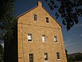
The Old Aztec Mill, now a museum.
-
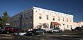
The historic St. James Hotel.


See also
 In Spanish: Cimarron (Nuevo México) para niños
