
Clara Vale facts for kids
Quick facts for kids Clara Vale |
|
|---|---|
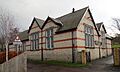
 The old school, now a community centre |
|

Clara Vale
|
|
| Population | 313 (2011 census) |
| OS grid reference | NZ133649 |
| Metropolitan borough |
|
| Metropolitan county | |
| Region | |
| Country | England |
| Sovereign state | United Kingdom |
| Post town | RYTON |
| Postcode district | NE40 |
| Dialling code | 0191 |
| Police | Northumbria |
| Fire | Tyne and Wear |
| Ambulance | North East |
| EU Parliament | North East England |
| UK Parliament |
|
Clara Vale is a small village in England, located right by the River Tyne. It's part of Tyne and Wear, but it used to be in County Durham. In 1974, it became part of the Metropolitan Borough of Gateshead.
Contents
Where is Clara Vale Located?
Clara Vale sits on the south side of the River Tyne. It's a quiet and somewhat hidden spot. To the south, you'll find Crawcrook. Across the river in Northumberland are Close House and the village of Wylam. Clara Vale is the first place the River Tyne reaches in Tyne and Wear after leaving Northumberland.
A Look Back at Clara Vale's History
Before Clara Vale became a village, there was a corn mill called Crawcrook Mill. It used water power and had two small cottages. A special well, called Edington Well, fed the mill pond. This old well can still be seen near the road south of the village.
The only road into Clara Vale is Stannerford Road. It's named after an old crossing point over the River Tyne. This ford used to connect Crawcrook to the south with Heddon-on-the-Wall to the north.
Maps from the 1850s show a farmhouse called Stanner House. It was later split into two homes and taken down in the 1960s.
How Clara Vale Began: The Coal Mine
Clara Vale was built especially for a coal mining community. The Stella Coal Company opened the coal mine in July 1893. The village and the mine were named after Clara Atkinson (née Draper). She was the wife of the mine owner, John Bell Simpson. Some old maps even called the village "Claraville."
A church called the Church of the Good Shepherd stood in the village from 1886 to 1979. It was a "tin tabernacle," meaning it was made of corrugated iron. Miners also had two different institutes over the years. The last one was removed in the early 1990s.
The village school taught children from ages 5 to 14. It was open from 1898 to 1962. In 1967, a community group took over the school building. They turned it into a community centre and village hall, run by volunteers.
The Mine's Peak and Closure
The Clara Vale colliery was very busy in 1925, with 1221 workers. By 1965, this number dropped to 562. The mine closed in February 1966, around the same time as other nearby mines.
After the mine closed, Clara Vale was given "Category D" status by the local council. This meant that new investments were not encouraged. It was thought the village would slowly decline over time.
Many old mine buildings stayed empty until the 1980s when they were taken down. However, the original ambulance shed is still there. The building where miners used to wash after work was used by different companies. For some years, it was even a sound recording studio. Sadly, fires in the 2010s damaged and eventually destroyed it.
Clara Vale Today: A Rural Village
Clara Vale has kept its quiet, countryside feel. It hasn't become a busy suburban area like nearby towns. Farmland and nature surround the village.
The site of the old coal mine is now a Local Nature Reserve. A group of volunteers, the Clara Vale Conservation Group, looks after it. They work to protect the different plants and animals living there.
Not much new building has happened in Clara Vale. A bungalow was built in 1984 where the village shop used to be. In 1997, a short street of terraced houses was built. These new homes fit the village's traditional style.
The old Co-Op building, from around 1900, was empty for many years. In the mid-2010s, it was turned into flats. Around the same time, the Methodist chapel became a private home. The Sunday school next to it was changed into an Airbnb holiday rental.
The village hall has been updated and offers many activities. You can rent rooms for sports or events. There are also groups, classes, community meals, and sometimes music and theatre shows. In the 2010s, part of the hall was made into small offices. These are rented out, which helps pay for the building's upkeep.
Clara Vale doesn't have any shops. In the past, mobile shops like greengrocers and butchers visited. But nearby Crawcrook, Ryton, and Wylam have many shops and services. So, even though Clara Vale feels secluded, it's not cut off from everything.
Sports and Recreation in Clara Vale
The village recreation ground was first set up by the mine owners for the miners. It used to have a bowling green and tennis courts. These are now part of the nature reserve. However, the football pitch, cricket pitch, and pavilion are still used a lot.
Clara Vale Cricket Club plays matches there on Saturdays in the summer. Other clubs also use the pitch on Sundays and some Wednesday evenings. The Ryton and Crawcrook Albion (Youth) Football Club uses the football pitch too.
Ryton Golf Club is on the north edge of the village. It started in 1891. In 1982, it grew to include land that used to be allotment gardens and part of the old mine railway. Tyneside Golf Club is based in Ryton, but its course is right next to Clara Vale. Close House golf club is across the river to the north.
Images for kids
-
The old school, now a community centre
