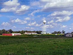
Clarkrange, Tennessee facts for kids
Quick facts for kids
Clarkrange, Tennessee
|
|
|---|---|
 |
|
| Country | United States |
| State | Tennessee |
| County | Fentress |
| Area | |
| • Total | 10.16 sq mi (26.30 km2) |
| • Land | 10.16 sq mi (26.30 km2) |
| • Water | 0.00 sq mi (0.00 km2) |
| Elevation | 1,821 ft (555 m) |
| Population
(2020)
|
|
| • Total | 596 |
| • Density | 58.68/sq mi (22.66/km2) |
| Time zone | UTC-6 (Central (CST)) |
| • Summer (DST) | UTC-5 (CDT) |
| ZIP code |
38553
|
| Area code(s) | 931 |
| GNIS feature ID | 1305941 |
| FIPS code | 47-15120 |
Clarkrange is a small community in Fentress County, Tennessee, in the United States. It is not a city with its own government, but a "census-designated place" (CDP). This means it is a special area the government counts for population. Clarkrange is located where two main roads meet: U.S. Route 127 and Tennessee State Route 62. This area is part of Tennessee's western Cumberland Plateau region. In 2020, about 596 people lived here.
The community has its own post office, which opened in 1885. Its ZIP code is 38553. Clarkrange is also home to Clarkrange High School. This is the only public high school run by the county school district.
Clarkrange got its name from Cyrus Clark. He ran an inn and a cattle ranch in the area in the late 1800s. Before he arrived, local farmers used the land as a "free range" area for their cattle. This meant the cattle could roam freely.
Clarkrange High School has a JROTC raider team. This team has won first place in the national raider competition two years in a row!
Contents
Geography of Clarkrange
Clarkrange is in the southern part of Fentress County. The southern border of the community is shared with Cumberland County. The main crossroads in town are just a little bit south of the Tennessee Valley Divide. This "divide" is like a line on the land where water flows in different directions.
- Water on the south side of town flows into Clear Creek. This creek forms the border with Cumberland County. It then flows east into the Obed River, and eventually into the Tennessee River.
- Water on the northwest side of town flows into Slate Creek. This creek leads to the East Fork of the Obey River, which then flows into the Cumberland River.
- Water on the northeast side flows into the North Prong of Clear Fork. This then goes into the Big South Fork of the Cumberland River.
U.S. Route 127 goes north about 18 miles (29 km) to Jamestown. Jamestown is the main town in Fentress County. Route 127 also goes south about 18 miles (29 km) to Crossville. Tennessee State Route 62 goes east about 29 miles (47 km) to Wartburg. It goes west about 16 miles (26 km) to Monterey.
The Clarkrange CDP covers an area of about 10.16 square miles (26.3 square kilometers). All of this area is land.
People in Clarkrange
| Historical population | |||
|---|---|---|---|
| Census | Pop. | %± | |
| 2020 | 596 | — | |
| U.S. Decennial Census | |||
According to the 2020 United States census, there were 596 people living in Clarkrange. There were 289 households and 241 families. Most of the people living in Clarkrange are White (95.64%).
Sports in Clarkrange
Basketball
Clarkrange High School is famous for its girls' basketball team, the Lady Buffaloes. They have won eight state championship titles in Tennessee Class A Girls' Basketball! They won in these years: 1983, 1984, 1985, 1990, 1991, 1995, 2004, and 2009.
Chess
Clarkrange High School is also well-known for its chess team. The team won national championships in 2000, 2004, and 2008.
See also
 In Spanish: Clarkrange para niños
 | Victor J. Glover |
 | Yvonne Cagle |
 | Jeanette Epps |
 | Bernard A. Harris Jr. |


