Clarksburg, Massachusetts facts for kids
Quick facts for kids
Clarksburg, Massachusetts
|
|||||
|---|---|---|---|---|---|
| Town of Clarksburg | |||||

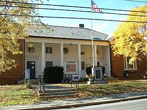
Clarksburg Town Hall on an autumn day in 2004.
|
|||||
|
|||||

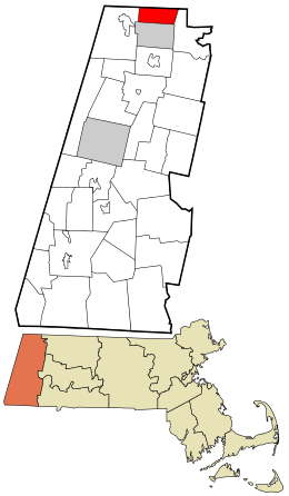
Location in Berkshire County and Massachusetts.
|
|||||
| Country | United States | ||||
| State | Massachusetts | ||||
| County | Berkshire | ||||
| Settled | 1764 | ||||
| Incorporated | 1798 | ||||
| Government | |||||
| • Type | Open town meeting | ||||
| Area | |||||
| • Total | 12.8 sq mi (33.3 km2) | ||||
| • Land | 12.8 sq mi (33.0 km2) | ||||
| • Water | 0.1 sq mi (0.2 km2) | ||||
| Elevation | 1,138 ft (347 m) | ||||
| Population
(2020)
|
|||||
| • Total | 1,657 | ||||
| • Density | 129.5/sq mi (49.76/km2) | ||||
| Time zone | UTC-5 (Eastern) | ||||
| • Summer (DST) | UTC-4 (Eastern) | ||||
| ZIP code |
01247
|
||||
| Area code(s) | 413 | ||||
| FIPS code | 25-14010 | ||||
| GNIS feature ID | 0619417 | ||||
Clarksburg is a small and friendly town located in Berkshire County, Massachusetts, in the United States. It's part of the larger Pittsfield area. In 2020, about 1,657 people called Clarksburg home.
Contents
How Did Clarksburg Begin?
Clarksburg was first settled in 1764. It officially became a town in 1798.
Early Settlers and Growth
Three important people helped settle the area in 1769. They were Captain Matthew Ketchum, Colonel William Bullock, and Nicholas Clark. The town was later named after Nicholas Clark.
Mills and Industry
Clarksburg started as a farming community. People grew crops and raised animals. Later, factories called mills were built along the rivers in the 1800s. These mills used water power to make things. Some mills made cashmere, a soft fabric. Other mills made gunpowder, which was used during the Civil War. However, the town stopped this industry after one of the gunpowder mills exploded in 1869.
What is Clarksburg's Geography Like?
Clarksburg covers about 12.8 square miles (33.3 square kilometers). Most of this area is land, with a small amount of water.
Location and Borders
Clarksburg is located at 42°42'42.86"N, 73°05'02.97"W. It shares borders with other towns and states. To the north are Pownal and Stamford in Vermont. To the east is Florida, Massachusetts. North Adams is to the south, and Williamstown is to the west.
Mountains and Rivers
The town is surrounded by mountains. East Mountain and Bald Mountain are to the west. The Hoosac Range is to the east. Between these mountains, two streams flow through the valley. These are Hudson Brook and the north branch of the Hoosic River. They join together just south of the town.
Parks and Trails
In the northern part of the valley, you'll find Clarksburg State Park. This park is run by the state's Department of Conservation and Recreation. It has a pond called Mauserts Pond. Visitors can enjoy picnics, go hiking, and camp there. The Green Mountain National Forest is also nearby, just across the border in Vermont.
The famous Appalachian Trail also passes through Clarksburg. It goes from north to south, just west of East Mountain. East Mountain is the highest point in town, reaching about 2,300 feet (701 meters) high.
Roads and Transportation
Route 8 is the main road that goes through Clarksburg. The closest major highway is Interstate 91. This highway is about 35 miles (56 km) east of town. You can reach it by taking Route 2, also known as the Mohawk Trail. The Mohawk Trail ends just south of Clarksburg.
There are no train services in town. The closest bus services are in North Adams. For air travel, the nearest small airport is Harriman and West Airport in North Adams. For bigger flights, the Albany International Airport is the closest option.
Who Lives in Clarksburg?
| Historical population | ||
|---|---|---|
| Year | Pop. | ±% |
| 1850 | 384 | — |
| 1860 | 420 | +9.4% |
| 1870 | 686 | +63.3% |
| 1880 | 724 | +5.5% |
| 1890 | 884 | +22.1% |
| 1900 | 943 | +6.7% |
| 1910 | 1,207 | +28.0% |
| 1920 | 1,136 | −5.9% |
| 1930 | 1,296 | +14.1% |
| 1940 | 1,317 | +1.6% |
| 1950 | 1,630 | +23.8% |
| 1960 | 1,741 | +6.8% |
| 1970 | 1,987 | +14.1% |
| 1980 | 1,871 | −5.8% |
| 1990 | 1,745 | −6.7% |
| 2000 | 1,686 | −3.4% |
| 2010 | 1,702 | +0.9% |
| 2020 | 1,657 | −2.6% |
| 2022* | 1,643 | −0.8% |
| * = population estimate. Source: United States Census records and Population Estimates Program data. |
||
In 2010, about 1,702 people lived in Clarksburg. There were 675 households, which are groups of people living together. About 507 of these were families.
Population Details
Clarksburg is the 20th largest town by population in Berkshire County. It is the 302nd largest out of 351 cities and towns in Massachusetts. The town has about 133 people per square mile (51 people per square kilometer).
Most of the people in Clarksburg are White (98.8%). A small number are African American (0.2%) or from other backgrounds. About 0.9% of the population is Hispanic or Latino.
Households and Families
About 27.7% of households had children under 18 living there. Most households (60.3%) were married couples living together. About 8.7% had a female head of household with no husband present. Around 24.9% were non-family households.
About 20.3% of all households were people living alone. And 9.2% had someone aged 65 or older living by themselves. The average household had 2.52 people. The average family had 2.89 people.
Age and Income
The population in Clarksburg is spread out by age. About 22.2% of people were under 19 years old. About 31.6% were between 45 and 64 years old. And 17.6% were 65 years or older. The average age in town was 45 years.
The average income for a household in Clarksburg was $57,600. For families, the average income was $62,639. The average income per person in the town was $28,274. A small number of families (3.5%) and people (6.2%) lived below the poverty line.
What About Education in Clarksburg?
Clarksburg has its own school for younger students. It's called Clarksburg Elementary. This school teaches students from kindergarten all the way through eighth grade.
High School and Beyond
After eighth grade, students from Clarksburg go to Drury High School in nearby North Adams, MA. Students also have other choices. They can apply to attend Charles H. McCann Technical High School, also in North Adams. Another option is the Berkshire Arts & Technology Charter Public School in Adams. There are also private schools in North Adams and Williamstown that accept students from Clarksburg.
For college, the closest community college is Berkshire Community College in Pittsfield. The nearest public college is Massachusetts College of Liberal Arts in North Adams. The closest big university is the University of Massachusetts Amherst. The nearest private college is Williams College in Williamstown.
See also
 In Spanish: Clarksburg (Massachusetts) para niños
 | Delilah Pierce |
 | Gordon Parks |
 | Augusta Savage |
 | Charles Ethan Porter |


