Claughton, Lancaster facts for kids
Quick facts for kids Claughton |
|
|---|---|
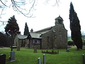
 St Chad's Church, Claughton, now redundant |
|
| Population | 209 (2011) |
| OS grid reference | SD562664 |
| Civil parish |
|
| District | |
| Shire county | |
| Region | |
| Country | England |
| Sovereign state | United Kingdom |
| Post town | LANCASTER |
| Postcode district | LA2 |
| Dialling code | 01524 |
| Police | Lancashire |
| Fire | Lancashire |
| Ambulance | North West |
| EU Parliament | North West England |
| UK Parliament |
|
Claughton (pronounced KLAF-tun) is a small village in Lancashire, England. It's part of the City of Lancaster area. You can find it east of the city of Lancaster, right on the A683 road.
In 2011, Claughton and a nearby area called Roeburndale had a combined population of about 223 people. North of the village, you'll find the River Lune. To the south are Claughton Moor and the hills of the Forest of Bowland.
What Claughton Makes
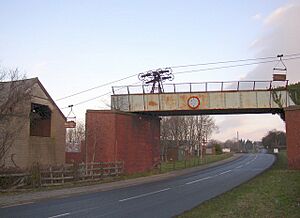
Claughton is home to a place called Claughton Brickworks. This is where they make bricks!
To get the clay needed for bricks, they use something cool called a ropeway conveyor. These conveyors are like long lines of buckets or carriers that hang in the air. They carry clay all the way from Claughton Moor to the brickworks, even going over the main road (the A683).
Claughton's Old Church
The village used to have a church called St Chad's Church, Claughton. It was a very old church, with records showing there was a church on that spot as early as the year 1100.
However, the church was closed by the Church of England in 2002. This happened because fewer people were attending services, and the building needed a lot of updates.
Claughton's Railway Past
Claughton once had a railway station, though it was more like a small building for a crossing keeper. It was part of the old "Little" North Western Railway line.
Trains traveling between Lancaster Green Ayre railway station and Wennington railway station would stop at Claughton. This stop was located between the villages of Caton and Hornby. For example, in 1853, a train from Morecambe to Skipton would stop in Claughton at 11:35 AM.
 | Jessica Watkins |
 | Robert Henry Lawrence Jr. |
 | Mae Jemison |
 | Sian Proctor |
 | Guion Bluford |


