Clay County, Georgia facts for kids
Quick facts for kids
Clay County
|
||
|---|---|---|

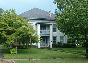
Clay County Courthouse in Fort Gaines
|
||
|
||

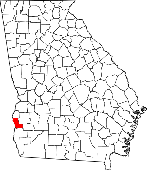
Location within the U.S. state of Georgia
|
||
 Georgia's location within the U.S. |
||
| Country | ||
| State | ||
| Founded | 1854 | |
| Named for | Henry Clay | |
| Seat | Fort Gaines | |
| Largest city | Fort Gaines | |
| Area | ||
| • Total | 217 sq mi (560 km2) | |
| • Land | 195 sq mi (510 km2) | |
| • Water | 22 sq mi (60 km2) 10.1%% | |
| Population
(2020)
|
||
| • Total | 2,848 | |
| • Estimate
(2023)
|
2,853 |
|
| • Density | 13.12/sq mi (5.067/km2) | |
| Time zone | UTC−5 (Eastern) | |
| • Summer (DST) | UTC−4 (EDT) | |
| Congressional district | 2nd | |
Clay County is a county located in the southwestern part of Georgia. In 2020, about 2,848 people lived there. This makes it one of the least populated counties in Georgia. The main town and county seat is Fort Gaines.
Contents
History of Clay County
This area was once home to the Creek Indians. In the 1830s, European Americans forced them to leave their lands. These new settlers then grew cotton, using thousands of African people who were forced into slavery to work the farms.
The county is named after Henry Clay. He was a famous American statesman and a member of the United States Senate from Kentucky. He also served as United States Secretary of State in the 1800s.
Clay County is part of a fertile area called the Black Belt. Before the American Civil War, cotton was the main crop. It was grown and processed by farmers and enslaved African Americans. After the war, farming continued, but timber (wood from trees) also became important.
Clay County was officially created on February 16, 1854. It was formed from parts of Early and Randolph counties. The number of people living in Clay County today is only about one-third of what it was in 1910.
Geography of Clay County
Clay County covers a total area of about 217 square miles. Most of this, about 195 square miles, is land. The remaining 22 square miles (10.1%) is water.
The central and southwestern parts of Clay County are in the Lower Chattahoochee River area. This area is part of a larger river system called the ACF River Basin. The northwestern corner of the county is in the Middle Chattahoochee River-Walter F. George Lake area. A small part of the southeastern corner is in the Spring Creek area.
Major Highways in Clay County
These are the main roads that go through Clay County:
- U.S. Route 27
- State Route 1
- State Route 37
- State Route 39
- State Route 266
Counties Near Clay County
Clay County shares borders with these other counties:
- Quitman County - to the north
- Randolph County - to the northeast
- Calhoun County - to the east
- Early County - to the south
- Henry County, Alabama - to the west
- Barbour County, Alabama - to the northwest
People of Clay County
| Historical population | |||
|---|---|---|---|
| Census | Pop. | %± | |
| 1860 | 4,893 | — | |
| 1870 | 5,493 | 12.3% | |
| 1880 | 6,650 | 21.1% | |
| 1890 | 7,817 | 17.5% | |
| 1900 | 8,568 | 9.6% | |
| 1910 | 8,960 | 4.6% | |
| 1920 | 7,557 | −15.7% | |
| 1930 | 6,943 | −8.1% | |
| 1940 | 7,064 | 1.7% | |
| 1950 | 5,844 | −17.3% | |
| 1960 | 4,551 | −22.1% | |
| 1970 | 3,636 | −20.1% | |
| 1980 | 3,553 | −2.3% | |
| 1990 | 3,364 | −5.3% | |
| 2000 | 3,357 | −0.2% | |
| 2010 | 3,183 | −5.2% | |
| 2020 | 2,848 | −10.5% | |
| 2023 (est.) | 2,853 | −10.4% | |
| U.S. Decennial Census 1790-1880 1890-1910 1920-1930 1930-1940 1940-1950 1960-1980 1980-2000 2010 2020 |
|||
| Race / Ethnicity (NH = Non-Hispanic) | Pop 2000 | Pop 2010 | Pop 2020 | % 2000 | % 2010 | % 2020 |
|---|---|---|---|---|---|---|
| White alone (NH) | 1,282 | 1,188 | 1,143 | 38.19% | 37.32% | 40.13% |
| Black or African American alone (NH) | 2,009 | 1,920 | 1,593 | 59.85% | 60.32% | 55.93% |
| Native American or Alaska Native alone (NH) | 4 | 11 | 1 | 0.12% | 0.35% | 0.04% |
| Asian alone (NH) | 9 | 10 | 6 | 0.27% | 0.31% | 0.21% |
| Pacific Islander alone (NH) | 1 | 1 | 0 | 0.03% | 0.03% | 0.00% |
| Other race alone (NH) | 0 | 0 | 7 | 0.00% | 0.00% | 0.25% |
| Mixed race or Multiracial (NH) | 20 | 27 | 57 | 0.60% | 0.85% | 2.00% |
| Hispanic or Latino (any race) | 32 | 26 | 41 | 0.95% | 0.82% | 1.44% |
| Total | 3,357 | 3,183 | 2,848 | 100.00% | 100.00% | 100.00% |
In 2020, the census counted 2,848 people living in Clay County. There were 1,242 households and 708 families.
2010 Census Information
According to the 2010 United States census, there were 3,183 people in the county. There were 1,331 households and 869 families. The population density was about 16 people per square mile.
About 60.4% of the people were Black or African American. Around 37.6% were White. Other groups included Asian, American Indian, and people of two or more races. About 0.8% of the population was of Hispanic or Latino origin.
Of the households, 27.3% had children under 18 living with them. About 37.5% were married couples. The average household had 2.35 people. The average age of people in the county was 45.8 years old.
The average income for a household was $26,250 per year. For families, it was $31,354. About 34.2% of the population lived below the poverty line. This included 56.7% of those under 18 and 16.0% of those 65 or older.
Education
Communities in Clay County
Cities
Unincorporated Communities
These are places that are not officially organized as cities:
- Pecan
- Suttons Corner
- Zetto
Ghost Town
See also
 In Spanish: Condado de Clay (Georgia) para niños
 | William Lucy |
 | Charles Hayes |
 | Cleveland Robinson |


