
Clayton, Louisiana facts for kids
Quick facts for kids
Clayton, Louisiana
|
|
|---|---|
|
Town
|
|
| Town of Clayton | |

Clayton welcome sign
|
|

Location of Clayton in Concordia Parish, Louisiana.
|
|
.svg)
Location of Louisiana in the United States
|
|
| Country | United States |
| State | Louisiana |
| Parish | Concordia |
| Area | |
| • Total | 1.64 sq mi (4.23 km2) |
| • Land | 1.58 sq mi (4.10 km2) |
| • Water | 0.05 sq mi (0.14 km2) |
| Elevation | 56 ft (17 m) |
| Population
(2020)
|
|
| • Total | 584 |
| • Density | 369.15/sq mi (142.55/km2) |
| Time zone | UTC-6 (CST) |
| • Summer (DST) | UTC-5 (CDT) |
| Area code(s) | 318 |
| FIPS code | 22-15850 |
Clayton is a small town located in the northern part of Concordia Parish, Louisiana, United States. In 2020, about 584 people lived there.
One of the main crops grown in the area is cotton. Clayton is also situated on the Tensas River. This river is important for fishing and boating. The U.S. Army Corps of Engineers helps maintain a boat launch there. The Tensas River eventually joins the Black River in a town called Jonesville.
A state representative named Andy Anders comes from Clayton and a nearby town called Ferriday.
Some local businesses in Clayton include Cross Keys Bank and David's Grocery.
A big employer in the town used to be the Clayton Gin Company. A "gin" is a machine that separates cotton fibers from their seeds. This company closed down in the early 2000s. Most of its buildings were taken down around 2010. The gin was first built in the 1940s by two brothers, W. Howard Davis and Doyle E. Davis. It was known as "Davis Bros. Gin Co." After the last brother, Howard Davis, passed away in 1972, his son-in-law, Sam D. Cole, managed it until 1979. The gin was sold in the early 1980s and continued as the "Clayton Gin Company" until it closed.
Contents
Exploring Clayton's Location
Clayton is found in northern Concordia Parish. It sits on the south bank of the Tensas River. Across the river to the north is Catahoula Parish.
How to Get Around Clayton
U.S. Route 425 goes right through the middle of Clayton. If you head north on this road, it's about 36 miles to Winnsboro. Going south, it's about 6 miles to Ferriday and 18 miles to Natchez, Mississippi.
U.S. Route 65 starts in Clayton. If you follow it north, it's about 56 miles to Tallulah. This road goes all the way to Minnesota, which is about 998 miles away!
Size of Clayton
The town of Clayton covers a total area of about 1.64 square miles (4.23 square kilometers). Most of this area, about 1.58 square miles (4.10 square kilometers), is land. The rest, about 0.05 square miles (0.14 square kilometers), is water, which is about 3.24% of the total area.
Who Lives in Clayton?
We can look at the population of Clayton over the years.
| Historical population | |||
|---|---|---|---|
| Census | Pop. | %± | |
| 1950 | 657 | — | |
| 1960 | 882 | 34.2% | |
| 1970 | 1,103 | 25.1% | |
| 1980 | 1,204 | 9.2% | |
| 1990 | 917 | −23.8% | |
| 2000 | 858 | −6.4% | |
| 2010 | 711 | −17.1% | |
| 2020 | 584 | −17.9% | |
| U.S. Decennial Census | |||
Clayton's Population in 2020
In the 2020 United States census, there were 584 people living in Clayton. These people lived in 189 households, and 107 of these were families.
Here's a look at the different groups of people living in Clayton in 2020:
| Group | Number of People | Percentage of Total |
|---|---|---|
| White (not Hispanic or Latino) | 143 | 24.49% |
| Black or African American (not Hispanic or Latino) | 426 | 72.95% |
| Asian | 1 | 0.17% |
| Other/Mixed (two or more races) | 8 | 1.37% |
| Hispanic or Latino | 6 | 1.03% |
Photo gallery
-
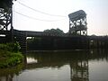
The Tensas River at Clayton, Louisiana -
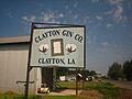
Clayton Cotton Gin


See also
 In Spanish: Clayton (Luisiana) para niños
