Clo-oose facts for kids
Quick facts for kids
Clo-oose
|
|
|---|---|
| Country | |
| Province | BC/BCE |
| Region | Vancouver Island |
| Regional District | Cowichan Valley |
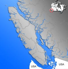
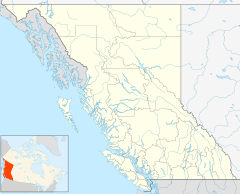
Clo-oose (which means tluu7uus in the Nuu-chah-nulth language) is a special place on the west coast of southern Vancouver Island, British Columbia. It's right next to where the Cheewhat River meets the ocean. This historic spot, once a steamboat stop, is now part of the Pacific Rim National Park Reserve. You can find it about 102 kilometers (63 miles) south of Port Alberni and 119 kilometers (74 miles) west of Duncan.
Contents
First Nations History at Clo-oose
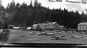
Clo-oose is part of the traditional lands of the Ditidaht First Nation. Their main villages were nearby: Whyac, about 3 kilometers (2 miles) north, and Qua-ba-diwa (Carmanah), about 7 kilometers (4 miles) south. Clo-oose was an important stopping point for First Nations people traveling and trading by canoe along the coast. Its name means "camping beach" or "landing place."
In 1791, when the ship Columbia visited, the people already showed signs of a past illness. By 1906, the combined population of the Ditidaht people at Whyac and Clo-oose was 198. However, by 1964, it was less than 30. In the early 1900s, the government encouraged Ditidaht-speaking people to live together at Clo-oose. A coastal steamboat visited every 10 days, bringing supplies. When this boat service stopped in 1952, many people moved away.
In the 1960s, the government helped people move to the head of Nitinat Lake. This new location had logging roads, making it easier to reach from Port Alberni or Lake Cowichan. This move happened around the same time as talks about creating a national park. The park would include Clo-oose, where some tribal members still spent part of the year.
European Settlers and Community Life
Europeans started visiting this area in the 1700s for fur trading. The first European settler was G.F. Groves. In 1892, he bought land on the Cheewhat River. He raised cattle and ran a store. In 1894, he asked David and Sarah Logan to manage his business while he visited Australia. Groves never returned.
That same year, Rev. William J. Stone started a Methodist mission. His daughter, Gwendolyn Hoop-Kwis-Tuck (born in 1898), was the first non-native person born in the community. Around 1906, Rev. Charles Docksteader took over the mission.
David Logan became the first postmaster from 1911 to 1938. Store owners often held this job in small communities. He was also a justice of the peace and a telegraph linesman. He also raised cattle. From 1913, many new settlers joined the few Europeans already at Clo-oose. They set up tents and built log cabins, hoping to find success. Their new area was called Clovelly, but Clo-oose remained the postal address.
Clo-oose did not have a safe harbor, so building a pier was not possible. Steamboats often faced delays due to bad weather and rough seas, sometimes waiting up to two months. When the water was calm enough, the boat would anchor offshore. Canoes would then paddle out to bring mail, goods, and passengers to the beach. People and supplies often got wet during this transfer.
A school operated in Clo-oose from 1913 to 1936. Many people from the community joined the military during World War I, and few returned after the war. A cannery (a factory for canning fish) operated nearby at Nitinat Narrows from 1917 to 1931. This was one of the few places to find work. By World War II, four of the seven remaining families left Clo-oose.
After the supply ship stopped coming, and with no roads, only a missionary and a linesman remained. However, the Ordway family arrived in 1953. By the late 1960s, only three families lived there for most of the year. In 1970, the area became part of the Pacific Rim National Park Reserve. To encourage the remaining residents to move, Parks Canada required them to live there full-time, which was very difficult.
Today, the old gardens have become wild again. Only a very old cabin stands near the West Coast Trail. English ivy and foxglove flowers grow among the ferns and salal plants. The old telegraph line is now rusty in the treetops.
Early Tourism Ideas for Clo-oose
In 1913, a company from Victoria called the West Coast Development Company printed a brochure. They wanted to promote a new oceanfront resort at Clo-oose. The Canadian Pacific Railway was already building similar tourist spots, like bungalow camps and luxury hotels such as the Banff Springs Hotel. However, Clo-oose and other parts of this coastline, served only by steamboats, had no such places for tourists.
The brochure claimed Clo-oose was an "easy distance" from Vancouver, Victoria, and Seattle. But it didn't mention that this was "as the crow flies" (a straight line), not by actual travel routes. The goal was to attract wealthy American tourists and also encourage new settlers to build up the community. These new residents were urged to buy waterfront lots quickly.
The plans included a large hotel, golf courses, tennis courts, croquet and bowling greens, a seaside boardwalk, and a big pier. To make it sound even better, they falsely claimed Clo-oose had mineral springs like the popular ones in Banff. They also wrongly said there were no mosquitoes. The Cheewhat River is affected by tides, making its water cold and salty, not good for swimming or drinking. Some of the "waterfront" properties for sale didn't even have ocean views, were landlocked, or were underwater at high tide. The start of World War I completely stopped this project.
Shipwrecks Near Clo-oose
The coast near Clo-oose has seen several shipwrecks.
- 1906: The Skagit, a type of sailing ship called a Barkentine, crashed on a reef northwest of Clo-oose. Two people lost their lives. Earlier that year, the SS Valencia sank 17 kilometers (11 miles) northwest, and more than 125 people died. Because of these disasters, the Canadian government set up a lifesaving station at Clo-oose in 1907.
- 1918: The Renfrew, a fishing boat called a purse seiner, wrecked on a sandbar near the Nitinat Narrows. Thirteen people died.
- 1923: The SS Santa Rita crashed on a reef to the southeast, but no one was lost.
- 1925: The Raita, a Schooner (another type of sailing ship), wrecked on the rocks near Whyac Point. Everyone on board survived.
Modern Tourism and the West Coast Trail
In 1970, the Pacific Rim National Park Reserve was created. In 1973, the old lifesaving trail became a popular hiking route known as the West Coast Trail. Clo-oose is almost exactly in the middle of this trail, at kilometer 35. In the 1960s, Helen Dorothy Ordway and her son ran a teahouse nearby. Another woman offered homemade beer to hikers. Both provided shelter to hikers during storms. Ordway was the last postmaster for Clo-oose from 1961 to 1966.
The West Coast Development Company was right about the region becoming popular, but not as a fancy seaside resort. Instead, it became a famous hiking destination. In recent years, some hikers have sadly wandered onto private properties, causing damage and stealing things. Graves have even been disturbed. In the late 1990s, the campground at Cheewat was closed. This helps make sure hikers stay on the main trail and don't disturb the historic sites.
Notable People Connected to Clo-oose
Marjorie Pickthall (1883–1922), a well-known poet and author, lived in Clo-oose from 1921 to 1922. Her poem, "Ebb Tide: The Sailor's Grave at Clo-oose, V.I.," mentions the community. This poem is thought to be a tribute to Charles Hansen and Ho Hee, who died on the Renfrew shipwreck and were buried on a small hill near the First Nations cemetery.
 | Bayard Rustin |
 | Jeannette Carter |
 | Jeremiah A. Brown |


