Cochituate, Massachusetts facts for kids
Quick facts for kids
Cochituate, Massachusetts
|
|
|---|---|

Cochituate School
|
|

Location in Middlesex County in Massachusetts
|
|
| Country | United States |
| State | Massachusetts |
| County | Middlesex |
| Town | Wayland |
| Area | |
| • Total | 4.17 sq mi (10.79 km2) |
| • Land | 3.81 sq mi (9.86 km2) |
| • Water | 0.36 sq mi (0.92 km2) |
| Elevation | 174 ft (53 m) |
| Population
(2020)
|
|
| • Total | 6,927 |
| • Density | 1,818.59/sq mi (702.18/km2) |
| Time zone | UTC-5 (Eastern (EST)) |
| • Summer (DST) | UTC-4 (EDT) |
| ZIP code |
01778 (Wayland)
|
| Area code(s) | 508 |
| FIPS code | 25-14570 |
| GNIS feature ID | 0611909 |
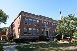
Cochituate (pronounced koh-CHIT-choo-it) is a special area called a census-designated place (CDP). It is located within the town of Wayland in Middlesex County, Massachusetts, United States. In 2020, about 6,927 people lived here. This is a part of the larger town of Wayland, which had a total population of 13,943 people.
Contents
Where is Cochituate Located?
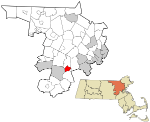
Cochituate is in the southwestern part of Middlesex County. It's in the southern area of the town of Wayland. The town of Natick is to the south, and the city of Framingham is to the west.
Main Roads and Travel
Several important roads pass through Cochituate. Massachusetts Route 27 is the main street. It goes north about 3 miles (5 km) to Wayland Center and south the same distance to Natick Center.
Massachusetts Route 30 (Commonwealth Road) runs through the southern part of Cochituate. This road goes east about 9 miles (14 km) to Newton and west about 4 miles (6 km) to the center of Framingham.
Interstate 90, also known as the Massachusetts Turnpike, crosses the southern part of Cochituate. The closest exit for this highway is about 1 mile (1.6 km) west in Framingham.
Lakes and Ponds
Cochituate covers about 4.17 square miles (10.79 square kilometers). Most of this area is land, but about 0.36 square miles (0.92 square kilometers) is water. This area is home to Lake Cochituate and Dudley Pond.
These water bodies are popular with local residents all year round. In the summer, people enjoy boating and fishing. In the winter, when the ice is thick enough, people go ice fishing. There is also a beach where Wayland residents can get a membership to enjoy the water.
Lake Cochituate is made up of four smaller ponds connected by shallow waterways. It is located in the towns of Natick, Framingham, and Wayland, about 16 miles (26 km) west of Boston. The name Cochituate comes from the Algonquin language and means "swift river." This name refers to Cochituate Brook, which connects the lake to the Sudbury River. The Sudbury River eventually flows into the larger Merrimack River.
How Many People Live in Cochituate?
| Historical population | |||
|---|---|---|---|
| Census | Pop. | %± | |
| 1980 | 6,126 | — | |
| 1990 | 6,046 | −1.3% | |
| 2000 | 6,768 | 11.9% | |
| 2010 | 6,569 | −2.9% | |
| 2020 | 6,927 | 5.4% | |
| U.S. Decennial Census | |||
The number of people living in Cochituate has changed over the years. In 2000, there were 6,768 people living here. By 2020, the population had grown to 6,927 people.
Families and Households
In 2000, there were 2,449 households in Cochituate. A household is a group of people living together in one home. About 38.5% of these households had children under 18 years old living with them. Many households were married couples living together.
The average household had about 2.70 people. For families, the average size was about 3.14 people.
Age Groups
The population in Cochituate includes people of all ages. In 2000, about 27.2% of the people were under 18 years old. About 16.0% were 65 years old or older. The average age of people living in Cochituate was 42 years old.
See also
 In Spanish: Cochituate (Massachusetts) para niños
 | Janet Taylor Pickett |
 | Synthia Saint James |
 | Howardena Pindell |
 | Faith Ringgold |

