
Colonial Peak facts for kids
Quick facts for kids Colonial Peak |
|
|---|---|

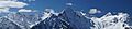
Colonial Peak seen from Diablo Lake overlook
|
|
| Highest point | |
| Elevation | 7,771 ft (2,369 m) NGVD 29 |
| Prominence | 1,171 ft (357 m) |
| Geography | |

Colonial Peak
Location in Washington (state)

Colonial Peak
Location in the United States
|
|
| Parent range | North Cascades |
| Topo map | USGS Ross Dam |
| Climbing | |
| First ascent | July 31, 1931 by William Degenhardt and Herbert Strandberg |
| Easiest route | West Ridge: glacier/snow climb, scramble (class 3) |
Colonial Peak is a tall mountain in the North Cascades area of Washington, United States. It stands out because it rises sharply from the side of Thunder Arm, which is part of Diablo Lake. Diablo Lake is a man-made lake on the Skagit River.
Colonial Peak is part of a chain of mountains. This chain includes other popular peaks for climbing, like Eldorado Peak, Forbidden Peak, and Goode Mountain. The mountain got its name from an old mining area on its slopes called the "Colonial mining claim."
Colonial Peak is special because it rises very steeply from the land around it. For example, it climbs about 6,560 feet (2,000 meters) from Thunder Arm in just 2.3 miles (3.7 km) horizontally. This makes it look very impressive, even though other mountains might be taller overall.
The first people to climb Colonial Peak were William Degenhardt and Herbert Strandberg. They reached the top on July 31, 1931. They were members of a climbing group called the Seattle Mountaineers.
The most common way to climb Colonial Peak is along its West Ridge. Climbers reach this route by going over the Colonial Glacier. To get there, you follow the Pyramid Lake Trail, which starts near Diablo Dam on the North Cascades Highway.
Weather at Colonial Peak
Colonial Peak is in a place with a "marine west coast" climate. This means it gets a lot of weather from the Pacific Ocean. Most weather systems move from the ocean towards the Cascade Mountains.
When these weather systems hit the tall Cascade Mountains, they are forced to rise. As the air goes up, it cools down and drops its moisture. This causes a lot of rain or snowfall on the western side of the North Cascades. This effect is called "orographic lift."
Because of this, the west side of the mountains gets a lot of precipitation, especially snow in winter. Winters are often cloudy. However, in summer, high pressure systems over the Pacific Ocean often bring clear skies. The snow here tends to be wet and heavy, which can lead to a high risk of avalanches.
How the Mountains Formed
The North Cascades mountains have a very rugged look. They feature sharp peaks, long ridges, and deep valleys carved by glaciers. The way these mountains look today is due to geological events that happened millions of years ago. These events caused big changes in the land, creating the tall peaks and deep valleys we see.
The Cascade Mountains began to form millions of years ago. Over time, large pieces of the Earth's outer layer, called tectonic plates, moved and crashed into each other. This movement caused volcanoes to erupt and new land to be pushed up.
About two million years ago, during the Pleistocene period, huge sheets of ice called glaciers covered the land. These glaciers moved across the landscape many times. As they moved, they scraped away rock and dirt. This action created the U-shaped valleys that are common in the area today. The combination of land being pushed up and glaciers carving out the valleys created the tall peaks and deep valleys of the North Cascades.
Images for kids
-
Colonial Peak (in the middle) as seen from Ruby Mountain
- You can check the weather forecast for Colonial Peak here: Mountain Forecast
