Corneille River facts for kids
Quick facts for kids Corneille River |
|
|---|---|

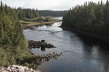
Corneille River looking north from Quebec Route 138
|
|
| Other name(s) | Rivière de la Corneille |
| Country | Canada |
| Province | Quebec |
| Region | Côte-Nord |
| RCM | Minganie |
| Physical characteristics | |
| River mouth | 0 metres (0 ft) 50°17′04″N 62°53′53″W / 50.2844444°N 62.8980556°W |
| Length | 82 kilometres (51 mi) |
| Basin features | |
| Basin size | 563 square kilometres (217 sq mi) |
The Corneille River (also known as Rivière de la Corneille in French, meaning "River of the Crow") is a beautiful river located in the Côte-Nord region of Quebec, Canada. It flows into the Gulf of Saint Lawrence, which is a large bay of the Atlantic Ocean, right across from Anticosti Island. This river is well-known for its amazing fishing and wildlife.
Contents
Discover the Corneille River's Location
The Corneille River stretches for about 82 kilometers (51 miles). The entire area of land where all the rain and snow drains into this river, called its watershed, covers 563 square kilometers (217 square miles).
Where the River Flows
The Corneille River is located between two other rivers. To its west is the Ours River. To its east is the Piashti River.
The river basin includes parts of different areas. These are the unorganized territory of Lac-Jérôme. It also covers parts of the towns of Baie-Johan-Beetz and Havre-Saint-Pierre. The river's mouth, where it meets the sea, is in the town of Baie-Johan-Beetz. This town is part of the Minganie Regional County Municipality. No one knows for sure how the river got its name.
Natural Surroundings
Maps of Quebec's natural regions show the river in specific areas. These areas are called sub-regions 6j-T and 6m-T. They are part of a larger area known for its spruce trees and moss.
Exploring the Corneille River
An old book from 1914, called the Dictionnaire des rivières et lacs de la province de Québec, describes the Corneille River. It says the river is on the north coast of the Saint Lawrence. It is located east of the Romaine and Ours rivers.
River Features
The river flows quite fast. Its path is broken up by several waterfalls. The Corneille River drains many beautiful lakes. These lakes are surrounded by mountains. The mountains range from 100 to 300 feet (30 to 91 meters) high.
Landscape and Wildlife
According to a report from 1899 by a surveyor named B.A. Houde, there isn't much wood along this river. From the first lake to the third, you mostly see burned trees and rocks. However, this river is very important for hunting and fishing. Trout are easy to catch here. There are also many animals with fur, like beavers and otters.
Fishing Adventures on the Corneille River
The La Corneille outfitter is a special company that has the only fishing rights. They control 19 kilometers (12 miles) of the Corneille River for fishing. They offer places to stay and easy ways to reach good spots for catching Atlantic salmon. You can also find lots of brook trout here.
The Outfitter's Location
The outfitter's main base is on a granite island. This island is where the Corneille River meets the Gulf of St. Lawrence. It is about 60 kilometers (37 miles) east of Havre-St-Pierre. You can get there by car using Quebec Route 138. The island is part of the beautiful Mingan Archipelago National Park Reserve.
Helping Salmon Travel Upstream
Only the first 9.3 kilometers (5.8 miles) of the river were easy for salmon to reach. This was because a 5.6-meter (18-foot) high waterfall blocked their way. This waterfall is located where Lake Tanguay flows into the Corneille River.
In 2014, a special project helped the salmon. Hydro-Québec funded this project. It was part of building the Romaine River hydroelectric dam. Workers created a new path for the salmon. They used controlled blasting to make a channel in the rock. This channel allowed about 10% of the river's water to flow through. This created a special "salmon run." This new path gave the fish access to an extra 60 kilometers (37 miles) of the river. It also meant salmon spent less time at the bottom of the falls. This reduced their risk of being caught illegally.
Monitoring the Salmon
After the new path was built, scientists kept a close eye on the salmon. They used electric fishing to count the fish. They also studied how the salmon interacted with other fish species upstream. This included salmon that live only in freshwater. A camera system was also set up. This helps to watch for anyone trying to fish illegally.
Catch-and-Release Fishing
In May 2015, the government announced a new rule for sport fishing. For large salmon, anglers had to practice "catch-and-release." This means you catch the fish, but then you must let it go. This rule applied to sixteen of Quebec's 118 salmon rivers.
These rivers included:
- Mitis River
- Laval River
- Pigou River
- Bouleau River
- Aux Rochers River
- Jupitagon River
- Magpie River
- Saint-Jean River
- Corneille River
- Piashti River
- Watshishou River
- Little Watshishou River
- Nabisipi River
- Aguanish River
- Natashquan River
The Quebec Atlantic Salmon Federation felt these rules were not enough. They believed that catch-and-release should be used on almost all rivers. This was important because the Atlantic salmon population was quickly getting smaller.
 | Delilah Pierce |
 | Gordon Parks |
 | Augusta Savage |
 | Charles Ethan Porter |


