Cortlandville, New York facts for kids
Quick facts for kids
Cortlandville, New York
|
|
|---|---|

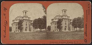
The Cortland Academy, Homer, NY
|
|
 |
|
| Country | United States |
| State | New York |
| County | Cortland |
| Government | |
| • Type | Town Council |
| Area | |
| • Total | 49.90 sq mi (129.24 km2) |
| • Land | 49.72 sq mi (128.78 km2) |
| • Water | 0.18 sq mi (0.46 km2) |
| Elevation | 1,099 ft (335 m) |
| Population
(2020)
|
|
| • Total | 8,409 |
| • Density | 171.1/sq mi (64.05/km2) |
| Time zone | UTC-5 (Eastern (EST)) |
| • Summer (DST) | UTC-4 (EDT) |
| ZIP code |
13045
|
| Area code(s) | 607 |
| FIPS code | 36-023-18421 |
| GNIS feature ID | 0978872 |
Cortlandville is a town located in Cortland County, New York State, in the United States. In 2020, about 8,409 people lived here.
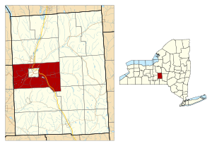
The town of Cortlandville completely surrounds the city of Cortland. It is also located on the western edge of Cortland County.
Contents
History of Cortlandville
Early Settlements and Growth
The land where Cortlandville is now was once part of the Central New York Military Tract. This was an area of land set aside for soldiers after the American Revolutionary War.
The first settlers arrived in 1792 at a place called Lorings Corners. Cortlandville officially became a town in 1829. It was created from the southern part of the town of Homer. Later, in 1845, more land was added from the town of Virgil.
Developing into a City
In 1853, the community of Cortland became an official village. It was recognized again as a village in 1864.
A special school was approved for the area in 1866. This school was called a "normal school." It was a place where people learned how to become teachers. Today, this school is known as the State University of New York at Cortland.
Geography of Cortlandville
Land and Water Features
Cortlandville covers a total area of about 49.90 square miles (129.2 square kilometers). Most of this area, about 49.72 square miles (128.8 square kilometers), is land. A small part, about 0.18 square miles (0.5 square kilometers), is water.
The Tioughnioga River flows through the town, heading south. This river is part of the larger Susquehanna River system. The western border of Cortlandville is also the border of Tompkins County.
Major Roads and Highways
Several important roads pass through Cortlandville. These include:
- Interstate 81
- U.S. Route 11
- New York State Route 281
These highways run from north to south.
Other roads run east to west:
- New York State Route 41
- New York State Route 222
Note that NY-41 turns north from Cortland. New York State Route 13 is another highway that goes northeast to southwest.
Population Changes in Cortlandville
| Historical population | |||
|---|---|---|---|
| Census | Pop. | %± | |
| 1830 | 3,573 | — | |
| 1840 | 3,799 | 6.3% | |
| 1850 | 4,203 | 10.6% | |
| 1860 | 4,817 | 14.6% | |
| 1870 | 6,082 | 26.3% | |
| 1880 | 7,114 | 17.0% | |
| 1890 | 2,861 | −59.8% | |
| 1900 | 2,907 | 1.6% | |
| 1910 | 3,155 | 8.5% | |
| 1920 | 3,237 | 2.6% | |
| 1930 | 3,520 | 8.7% | |
| 1940 | 3,823 | 8.6% | |
| 1950 | 4,058 | 6.1% | |
| 1960 | 5,660 | 39.5% | |
| 1970 | 7,469 | 32.0% | |
| 1980 | 8,299 | 11.1% | |
| 1990 | 8,054 | −3.0% | |
| 2000 | 7,919 | −1.7% | |
| 2010 | 8,509 | 7.5% | |
| 2020 | 8,409 | −1.2% | |
| U.S. Decennial Census | |||
The population of Cortlandville has changed over many years. In 1830, there were 3,573 people living in the town. The population grew steadily for many decades.
By 1970, the number of residents reached 7,469. In 2010, the population was 8,509. The most recent count in 2020 showed 8,409 people living in Cortlandville.
Places in Cortlandville
Cortlandville is home to several smaller communities and important locations:
- Blodgett Mills – This is a small community located in the southeast part of the town. It is on U.S. Route 11.
- Camp Tioughnioga – You can find this spot northwest of the city of Cortland.
- Cortland – The city of Cortland is a separate area. However, the town of Cortlandville completely surrounds it.
- Cortland County Airport, Chase Field (N03) – This airport is west of the city. It serves the local area. It is located near where NY-222 and NY-281 meet.
- Cortland West – This is a community on the western side of the town.
- Gracie – A small community found in the southwestern corner of the town.
- Homer – Most of the village of Homer is to the north in the town of Homer. But a small part of it extends south into Cortlandville on U.S. Route 11.
- Loring Crossing – This community is near the northern town line. It is northeast of Cortland.
- McGraw – The village of McGraw is in the eastern part of the town. It is located on NY-41.
- Munsons Corners – This community is on the southwestern border of the city of Cortland. It is located on NY-13.
- South Cortland – A community southwest of Cortland, also on NY-13.
See also
 In Spanish: Cortlandville (Nueva York) para niños
 | Roy Wilkins |
 | John Lewis |
 | Linda Carol Brown |


