Cotopaxi, Colorado facts for kids
Quick facts for kids
Cotopaxi, Colorado
|
|
|---|---|

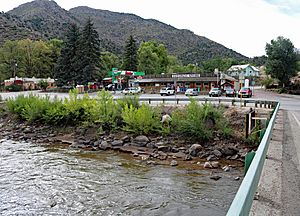
Cotopaxi on U.S. Route 50.
|
|

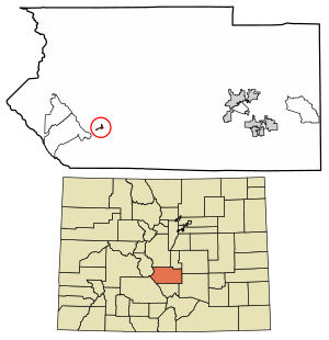
Location of the Cotopaxi CDP in Fremont County, Colorado.
|
|
| Country | |
| State | |
| County | Fremont County |
| Founded | 1882 |
| Government | |
| • Type | unincorporated community |
| Area | |
| • Total | 0.286 sq mi (0.740 km2) |
| • Land | 0.286 sq mi (0.740 km2) |
| • Water | 0 sq mi (0.000 km2) |
| Elevation | 6,450 ft (1,966 m) |
| Population
(2020)
|
|
| • Total | 44 |
| • Density | 154.0/sq mi (59.5/km2) |
| Time zone | UTC-7 (MST) |
| • Summer (DST) | UTC-6 (MDT) |
| ZIP Code |
81223
|
| Area code(s) | 719 |
| GNIS feature | Cotopaxi CDP |
Cotopaxi is a small community in Fremont County, Colorado, United States. It's not an official city, but it's recognized as a CDP. This means the government counts its population for statistics. Cotopaxi is part of the Cañon City, CO Micropolitan Statistical Area. In 2020, only 44 people lived there.
Contents
History of Cotopaxi
Cotopaxi got its name from the Cotopaxi Volcano in Ecuador. This volcano is one of the tallest active volcanoes in the world. Henry Thomas, an early explorer, chose the name in the mid-1800s.
Early Settlement Attempts
Cotopaxi is famous for an early group of about 63 Russian-Jewish immigrants. They came to Colorado in early 1882. These families hoped to start a successful farm community. They wanted to use the new Homestead Act. This law gave 160 acres of land to each family's male head.
When they arrived, only half of the promised houses were built. Many families had to live in small canvas tents during their first winter. They also didn't have enough supplies for winter or for planting crops. To get seeds and tools, they had to borrow a lot of money from the local store.
They tried to grow potatoes and corn. But the Colorado mountains only have a short growing season, less than four months. The first frost killed most of their crops. This meant they had to find other jobs to pay off their growing debt.
Working on the Railroad
Many men from the colony found work with the Denver and Rio Grande Western Railroad. The railroad was building more tracks over Marshall Pass. The men earned three dollars a day. This helped the struggling community survive its first winter.
They made it to spring, but their second crop also failed. Families started to leave Cotopaxi. Only about six families stayed to plant a third crop. A big blizzard destroyed this crop in June 1884. This ended the farming colony.
Cotopaxi was once a small train stop on the Denver and Rio Grande Western Railroad. This railroad ran along the Arkansas River.
Geography of Cotopaxi
Cotopaxi is located on both sides of the Arkansas River. It is about 33 miles west of Cañon City, which is the county seat. It's also about 25 miles southeast of Salida.
The Cotopaxi CDP covers an area of 0.740 square kilometers (about 0.286 square miles). All of this area is land.
Population Information
The United States Census Bureau first counted Cotopaxi as a CDP in 2010.
| Cotopaxi CDP, Colorado | ||
|---|---|---|
| Year | Pop. | ±% |
| 2010 | 47 | — |
| 2020 | 44 | −6.4% |
| Source: United States Census Bureau | ||
Economy and Businesses
Today, Cotopaxi has a few small businesses. The most well-known is the Cotopaxi General Store. This store opened in the early 1920s. It is now connected to a Sinclair gas station.
Even though the population is small, Cotopaxi attracts many visitors. A whitewater rafting business brings thousands of tourists each year. They come to enjoy rafting on the Arkansas River.
Education in Cotopaxi
Cotopaxi is home to the Cotopaxi School District Fremont RE-3. This school district provides education for western Fremont County. It serves Cotopaxi and nearby communities like Coaldale, Howard, Swissvale, and Wellsville. It also serves the Copper Gulch area.
Cotopaxi has two schools. They are Cotopaxi K-8 School and Cotopaxi High School. Both schools are located north of U.S. Highway 50.
Highways in Cotopaxi
See also
 In Spanish: Cotopaxi (Colorado) para niños
 | Aaron Henry |
 | T. R. M. Howard |
 | Jesse Jackson |


