Cranbury (CDP), New Jersey facts for kids
Quick facts for kids
Cranbury, New Jersey
|
|
|---|---|

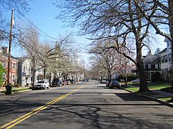
Center of Cranbury
|
|

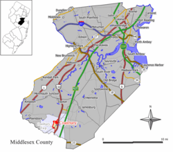
Map of Cranbury CDP in Middlesex County. Inset: Location of Middlesex County in New Jersey.
|
|
| Country | |
| State | |
| County | Middlesex |
| Township | Cranbury |
| Area | |
| • Total | 1.24 sq mi (3.22 km2) |
| • Land | 1.22 sq mi (3.17 km2) |
| • Water | 0.02 sq mi (0.05 km2) 1.57% |
| Elevation | 79 ft (24 m) |
| Population
(2020)
|
|
| • Total | 2,200 |
| • Density | 1,797.39/sq mi (694.16/km2) |
| Time zone | UTC−05:00 (Eastern (EST)) |
| • Summer (DST) | UTC−04:00 (Eastern (EDT)) |
| ZIP Code |
08512
|
| Area code(s) | 609 |
| FIPS code | 34-15520 |
| GNIS feature ID | 02389369 |
Cranbury is a small community in Middlesex County, New Jersey, in the United States. It's known as a census-designated place (CDP). This means it's an area that the government counts for population, but it's not a separate town or city.
As of the 2020 United States census, about 2,200 people live in Cranbury. Even though it's called "Cranbury," this community is only one part of the larger Cranbury Township.
Contents
Where is Cranbury Located?
Cranbury is found in the southern part of Middlesex County. This is in the east-central area of Cranbury Township.
How Big is Cranbury?
The community covers a total area of about 1.24 square miles (3.22 square kilometers). Most of this area is land, with a small amount of water.
Nearby Roads and Rivers
U.S. Route 130 runs along the eastern edge of Cranbury. This highway can take you south to Hightstown (about 2 miles away). It also goes north to New Brunswick, which is about 14 miles away. New Brunswick is important because it's the main town for Middlesex County. The state capital, Trenton, is about 15 miles to the southwest.
A small stream called Cranbury Brook flows through the southern part of the community. This brook eventually joins the Millstone River. The Millstone River then flows into the Raritan River, which finally reaches Lower New York Bay.
Who Lives in Cranbury?
The government counts how many people live in different areas. This is called a census.
| Historical population | |||
|---|---|---|---|
| Census | Pop. | %± | |
| 2000 | 2,008 | — | |
| 2010 | 2,181 | 8.6% | |
| 2020 | 2,200 | 0.9% | |
| Population sources: 2000 2010 2020 |
|||
What the 2010 Census Showed
In 2010, the census counted 2,181 people living in Cranbury. There were 722 households, which are groups of people living together.
Most people in Cranbury were White (about 82%). About 11% were Asian, and 4% were Black or African American. A small number of people were from other backgrounds. About 2% of the population identified as Hispanic or Latino.
Families and Age Groups
- About 45% of households had children under 18 years old.
- Most households (about 69%) were married couples living together.
- About 18% of households were people living by themselves.
- The average household had about 2.85 people.
The population of Cranbury also had different age groups:
- About 29% of people were under 18 years old.
- About 34% were between 45 and 64 years old.
- About 16% were 65 years old or older.
The average age of people in Cranbury was about 44.7 years.
See also
 In Spanish: Cranbury (Nueva Jersey) para niños
 | Jessica Watkins |
 | Robert Henry Lawrence Jr. |
 | Mae Jemison |
 | Sian Proctor |
 | Guion Bluford |


