
Cressbrook, Queensland facts for kids
Quick facts for kids CressbrookQueensland |
|||||||||||||||
|---|---|---|---|---|---|---|---|---|---|---|---|---|---|---|---|

Cressbrook
Location in Queensland
|
|||||||||||||||
| Population | 121 (2021 census) | ||||||||||||||
| • Density | 4.764/km2 (12.34/sq mi) | ||||||||||||||
| Postcode(s) | 4313 | ||||||||||||||
| Area | 25.4 km2 (9.8 sq mi) | ||||||||||||||
| Time zone | AEST (UTC+10:00) | ||||||||||||||
| Location |
|
||||||||||||||
| LGA(s) | Somerset Region | ||||||||||||||
| State electorate(s) | Nanango | ||||||||||||||
| Federal Division(s) | Blair | ||||||||||||||
|
|||||||||||||||
Cressbrook is a small country area in Queensland, Australia. It's part of the Somerset Region. In 2021, about 121 people lived there. Cressbrook is well-known for its fun flying activities.
Contents
Exploring Cressbrook's Landscape
Cressbrook is mostly farmland. People grow crops and raise animals here. There isn't a main town center. The Brisbane River forms its northern and eastern borders. A stream called Cressbrook Creek flows through the area. It eventually joins the Brisbane River. The Cressbrook-Carboonbah Road helps people travel through the area.
Cressbrook's Past: A Look at Its History
How Cressbrook Got Its Name
The name Cressbrook comes from the Cressbrook Homestead. This large farm was started in 1841 by David Cannon McConnel. He came from a village also called Cressbrook in England.
Early Land Use and Changes
In 1877, a big part of the Cressbrook farm, about 15,700 acres, was made available for new settlers.
Schools in the Past
Cressbrook Provisional School was open in 1881. However, it closed in 1882 because not enough students attended. Later, Cressbrook Lower State School opened in 1916. It closed its doors in 1953. Fulham State School also opened in 1920 and closed around 1953.
The Condensed Milk Factory
In 1898, the McConnel family built a factory in Cressbrook. They made condensed milk there. In 1907, a big company called Nestlé bought the factory.
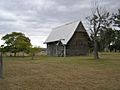
Victoria Chapel at Cressbrook Homestead

On June 1, 1901, David C. McConnel started building the Victoria Chapel. This chapel was for his family and their workers. It was a special place where people of different faiths could worship. Regular services for Anglicans and Presbyterians were held there. Other religious leaders also visited to hold services.
Who Lives in Cressbrook?
In 2016, about 117 people lived in Cressbrook. By 2021, the population had grown slightly to 121 people.
Learning in Cressbrook
There are no schools directly in Cressbrook today. Students usually go to schools in the nearby town of Toogoolawah. This includes Toogoolawah State School for primary students and Toogoolawah State High School for older students.
Special Places: Heritage Listings
Cressbrook has some important historical sites. One of these is the Cressbrook Homestead, located off Cressbrook-Caboombah Road. It is recognized for its special heritage value.
Watts Bridge Memorial Airfield: Where Aviation Takes Flight
Fun with Flying
The Watts Bridge Memorial Airfield is in the south-east of Cressbrook. It's a popular spot for sports and recreational flying. The airfield has three grass runways. These runways are about 900 meters, 820 meters, and 815 meters long. Many different flying clubs use the airfield. People fly vintage planes, gyroplanes, and gliders here. Some even do amazing acrobatics or go skydiving! Lots of fun flying events happen at the airfield each year.
Airfield's History: From War to Recreation
The airfield was first built in 1942 during World War II. It was part of Australia's defense efforts and was known as the Toogoolawah airfield. After the war, it was no longer needed for military use. The buildings were removed, and the land went back to being used for grazing animals.
In the early 1980s, a group of pilots wanted a place for recreational flying. They worked to rebuild the runways and taxiways. The airfield officially reopened in 1990 as the Watts Bridge Memorial Airfield. Its name comes from a nearby bridge that crossed the Brisbane River. This bridge was named after a local dairyman, James Robert Watts. The bridge was washed away in a big flood in 1974 and was never replaced.
Images for kids
-
Victoria Chapel at the Cressbrook Homestead, 2010
