Cullacabardee, Western Australia facts for kids
Quick facts for kids CullacabardeePerth, Western Australia |
|||||||||||||||
|---|---|---|---|---|---|---|---|---|---|---|---|---|---|---|---|

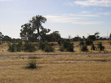
View east of Cullacabardee
|
|||||||||||||||
| Population | 80 (2016 census) | ||||||||||||||
| • Density | 6.2/km2 (16/sq mi) | ||||||||||||||
| Postcode(s) | 6067 | ||||||||||||||
| Area | 13 km2 (5.0 sq mi) | ||||||||||||||
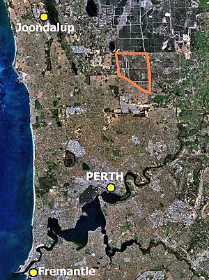
| Location | 21 km (13 mi) from Perth City | ||||||||||||||
| LGA(s) | City of Swan | ||||||||||||||
| State electorate(s) | West Swan | ||||||||||||||
| Federal Division(s) | Cowan | ||||||||||||||
|
|||||||||||||||
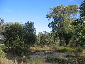
Cullacabardee is a quiet, natural suburb located northeast of Perth, the capital city of Western Australia. It's about 21 kilometers (13 miles) from Perth's city center. Most of Cullacabardee is covered in beautiful native forests, like sheoak and banksia trees. It's also home to a small community of Noongar people and a big telecommunications center. Cullacabardee is part of the City of Swan local government area.
Contents
Geography of Cullacabardee
Cullacabardee is located about 21 kilometers (13 miles) north of Perth's city center. It covers a large area of about 13 square kilometers (5 square miles). Its boundaries are set by major roads like Gnangara Road to the north and Alexander Drive to the west. Only one public road, Baal Street, goes into the area.
A big part of Cullacabardee is covered in important bushland. This area became part of Whiteman Park in 2000. The rest of the suburb is mainly used for general rural activities.
Cullacabardee sits over an underground water source called the Gnangara Mound. This mound provides a lot of drinking water for the Perth area. Because of this, the area is protected to prevent water pollution. The soil here is mostly sand, which doesn't hold much phosphorus. The main plants are low forests of sheoak and banksia trees, with some jarrah trees too.
Cullacabardee Aboriginal Community
A community for Aboriginal people has been in Cullacabardee since about 1980. It has 30 homes spread across 40 hectares (about 100 acres) of bushland. This community was created to help groups who were struggling to live in regular suburbs and might otherwise be homeless.
The first families moved into the homes in 1980. The Cullacabardee Aboriginal Corporation was officially formed in 1984. This group helps manage local programs and maintenance for the community. The housing is looked after by the state's Department of Housing.
Challenges Faced by the Community
Over the years, there have been discussions about challenges faced by the community. In 1999, it was reported that many residents found it hard to get jobs. There was no public transport, making it difficult to reach shops, schools, or health services. Residents often had to walk long distances to get to a bus stop or a shop. The nearest primary school was also quite far away.
Some homes in the community were being fixed up to help young people learn building skills. However, funding for these programs was often short-term, making it hard to offer longer training like apprenticeships. There were also issues with the land being zoned for rural use, which made it difficult to build more homes.
In 2003, some news reports talked about social difficulties within the community. Government officials later discussed these issues. In 2006, it was suggested that the community might close and residents could move to other housing in Perth. However, there has been no official update on this plan.
Perth International Telecommunications Centre
The Perth International Telecommunications Centre (PITC) is a large facility in Cullacabardee. It covers about 133.5 hectares (330 acres). This site was originally a radio station used by a company called the Overseas Telecommunications Commission (OTC) until 1986. OTC later became part of Telstra, a big telecommunications company.
In 1984, an agreement was made to build a long undersea cable connecting Jakarta, Singapore, and Perth. This cable, which is 4,473 kilometers (2,779 miles) long, helps connect Australia to other parts of the world. The PITC started operating in 1986 and still handles a large amount of Telstra's satellite communications today.
For many years, the PITC wanted a 1-kilometer (0.6-mile) buffer zone around its site where no homes could be built. This was to protect its operations. However, new residential areas have been planned near the facility. In 2006, an area west of Alexander Drive was changed from rural to urban zoning, allowing for more housing. It is not known if the PITC will need to move in the future because of this development.
Other Facilities
Transport
Cullacabardee does not have its own public transport services. The closest bus stop is in Ballajura, which is about a 6-kilometer (3.7-mile) walk from the Cullacabardee Aboriginal community.
 | Dorothy Vaughan |
 | Charles Henry Turner |
 | Hildrus Poindexter |
 | Henry Cecil McBay |


