Dalecarlia Reservoir facts for kids
Quick facts for kids Dalecarlia Reservoir |
|
|---|---|
| Location | Bethesda, Maryland / Washington, D.C. |
| Coordinates | 38°56′33.0216″N 77°6′36.1548″W / 38.942506000°N 77.110043000°W |
| Type | Reservoir |
| Primary inflows | Washington Aqueduct |
| Basin countries | United States |
| Surface area | 50 acres (20 ha) |
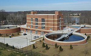
The Dalecarlia Reservoir is a very important place. It holds most of the drinking water for Washington, D.C.. This water comes from the Potomac River. It travels through an underground pipe system called an aqueduct. The aqueduct gets water from low dams near Great Falls and Little Falls.
The reservoir is located between two neighborhoods. These are Spring Valley and the Palisades in Northwest Washington. It is also near Brookmont in Montgomery County, Maryland.
Contents
Building the Dalecarlia Reservoir
The Dalecarlia Reservoir is about 50-acre (200,000 m2) in size. It was finished in 1858. The United States Army Corps of Engineers built it. This was part of a bigger project called the Washington Aqueduct.
Early Water Supply
The reservoir started giving water on January 3, 1859. At first, it got water from a nearby stream called Little Falls Branch. This was before the main aqueduct was fully built. Regular water service from the Potomac River began in 1864.
Improving the Reservoir
Over the years, the reservoir was updated. Changes were made in 1895 and again in 1935. These updates helped make the water cleaner. They also helped increase the amount of water available.
Nearby Landmarks
In 1942, the main office of the Army Map Service was built next to the reservoir. Some of these buildings from the 1940s are still there today. In 1946, their main office moved to the nearby Sumner Site. This site is now known as the Intelligence Community Campus-Bethesda.
Trails and Markers
The Capital Crescent Trail runs right next to the reservoir. It also goes through the area where the water pumps are. The border between Maryland and Washington, D.C. goes through the reservoir itself.
A historic D.C. boundary marker (Northwest No. 5) is located in the woods east of the reservoir. Another marker (Northwest No. 4) is a short distance east of the Capital Crescent Trail. It is near the Dalecarlia water purification building.
Who Takes Care of It?
The Washington Aqueduct division of the United States Army Corps of Engineers takes care of the reservoir. They make sure it works well.
 | Frances Mary Albrier |
 | Whitney Young |
 | Muhammad Ali |


