
Boundary markers of the original District of Columbia facts for kids
The boundary markers of the original District of Columbia are 40 special stones. These stones mark the original square shape of the federal territory. This territory later became the District of Columbia in 1801. The square covered 100 square miles (259 km²). It was located between the states of Maryland and Virginia.

In 1790, President George Washington chose three commissioners. They followed the federal Residence Act. A team of surveyors, led by Major Andrew Ellicott, placed these markers. This happened in 1791 and 1792. Some of Ellicott's helpers were his brothers Joseph and Benjamin Ellicott. Other team members included Isaac Roberdeau, George Fenwick, Isaac Briggs, and Benjamin Banneker. Benjamin Banneker was an African American astronomer.
Today, 36 of these original stones still exist. They are the oldest federally placed monuments in the United States. Thirteen of these markers are now in Virginia. This is because part of the District was returned to Virginia in 1846. This part was south and west of the Potomac River.
Contents
The District's Original Shape

The District of Columbia was first planned as a perfect square. It was 100 square miles (259 km²) in size. The corners of the square pointed north, south, east, and west. This made the District look like a diamond on most maps.
The southern corner of the square was at Jones Point in Alexandria, Virginia. This spot is where the Potomac River and Hunting Creek meet. Each side of the square was 10 miles (16 km) long.
The main lines of the District's current boundaries run differently. The north-south line goes from the District's north corner. It passes between 17th and 18th Streets, N.W. It then crosses the National Mall to the Potomac River. The east-west line is between Constitution Avenue and C Street, N.E. and N.W.
These lines are different from the ones that divide Washington D.C. into four parts. These parts are Northeast (N.E.), Northwest (N.W.), Southeast (S.E.), and Southwest (S.W.). These parts are usually added to Washington street addresses. They are generally separated by North Capitol Street, East Capitol Street, South Capitol Street, and the National Mall.
In 2011, a special mapping project used Global Positioning System (GPS) to map the District's boundary. They found that the old stones were very close to the actual lines. For example, the distance between two stones (Southeast 6 and 7) is almost exactly one mile.
You can find these stones in many places. Some are along streets, in public parks, or deep in the woods. Some are even on private property. If you are respectful, homeowners often let curious people see the stones on their land.
Setting Up the Boundary Stones

On March 30, 1791, President George Washington announced the starting point for the federal territory's boundary survey. This point was "Jones's point," a cape in Virginia. The survey team started their work there. This was at the southeast corner of Alexandria, Virginia. On April 15, 1791, officials held a special Masonic ceremony. They dedicated the south corner stone at the spot Andrew Ellicott had chosen.
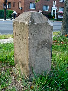
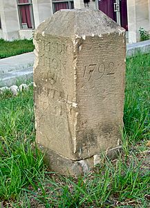
The survey team then cleared a path along the boundary. This made surveying easier. They moved clockwise from the starting point. They placed sandstone markers at the four corners. They also placed markers about every mile. The stones came from a quarry near Aquia Creek in Virginia. Most weighed about half a ton. The four cornerstones were a bit larger. The stones in Virginia were set in 1791. The Maryland stones were set in 1792.
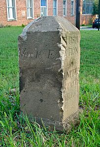
Each boundary marker had special carvings. The side facing the federal territory said "Jurisdiction of the United States." It also showed the distance in miles from the last corner stone. The other side had the name of the border state: Virginia or Maryland. The other two sides showed the year the stone was placed. They also showed the magnetic variation of the compass needle at that spot.
On January 1, 1793, Andrew Ellicott reported that the survey was finished. All the boundary markers were in place. Ellicott's report described the stones. It also included a map. This map showed the boundaries and natural features of the Territory of Columbia. It also showed where the planned City of Washington and its main streets would be. The map also marked the location of each boundary stone.
The images below show the sides of the Southeast No. 6 boundary marker stone in 2011:
-
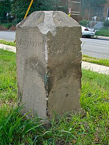
From north
-
From east
-
From south
-
From west
_SE_6_(view_from_east).jpg)

_SE_6_(view_from_west).jpg)
Protecting the Stones
Early Protection Efforts
In 1906, Fred E. Woodward wrote a paper about the boundary stones. He suggested putting small fences around each one to protect them. In 1909, Ernest A. Shuster also wrote an article. He visited the 36 remaining stones and asked for their protection.
In 1915, different groups of the Daughters of the American Revolution (DAR) started building fences around the markers. The DAR also placed a new marker stone at the exact center of the original federal territory. This marker is near the White House.
Official Recognition
Some Virginia boundary markers were added to the National Register of Historic Places in 1976 and 1980. In 1991, all the remaining Virginia markers were added. This happened after the Virginia DAR submitted a special request. In 1996, 23 markers along the D.C. and Maryland border were also added to the National Register.
Virginia Markers
Southwest 9. This marker in Virginia was added to the National Register in 1976. It was also named a U.S. National Historic Landmark. It was named the Benjamin Banneker: SW-9 Intermediate Boundary Stone. This was the first boundary marker to be listed.
South Corner. This marker in Virginia was added to the National Register in 1980. It was listed along with Alexandria's Jones Point Lighthouse. This marker replaced an earlier one in 1794.
Southwest 1, 2, 3, 4, 5, 6, 7, and 8; West Corner; Northwest 1, 2, and 3. These markers in Virginia were added to the National Register on February 1, 1991.
D.C. and Maryland Markers
Northwest 4, 5, 6, 7, 8, and 9; North Corner; Northeast 2, 3, 4, 5, 6, 7, 8, and 9; East Corner; Southeast 1, 2, 3, 5, 6, 7, and 9. These markers are along the border between the District of Columbia and Maryland. They were added to the National Register on November 1, 1996.
Ongoing Preservation Efforts
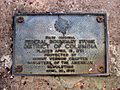
In 1976, a report suggested ways to keep the stones safe. In 1990 and 1991, a team found two stones that had been missing. This was part of a celebration for the markers' 200th birthday.
In 1995, a committee made a list of ideas to protect the 14 stones in Virginia. In 2008, some Virginia local governments agreed to help pay for a project to protect the stones. However, this project did not start by 2012. Volunteers then began to clean and repaint the fences around the stones. In 2012, the D.C. DAR restored the Northeast No. 7 marker and its fence.
In 2014, several groups started a new effort to fix the boundary markers. In 2015, a crew found a stone that had been buried since 1962. They planned to clean and restore it. However, in 2016, a new stone was put in its place. This new stone looked like the original when it was new.
List of Boundary Stones
Here is a list of the 36 existing and four missing boundary stones. They are listed in the order they were placed, starting from the southern corner and going clockwise. The tables also show the year each stone was added to the National Register of Historic Places.
Southern Corner
| Name | Image | Address | City/County | Coordinates | Status | Year Listed |
|---|---|---|---|---|---|---|
| South Cornerstone of the Original District of Columbia | _South_Cornerstone_close-up.jpg) 2010
|
Seawall south of lighthouse, Jones Point Park, 1 Jones Point Drive, Alexandria | City of Alexandria, Virginia; Prince George's County, Maryland | 38°47′25″N 77°02′26″W / 38.79033915°N 77.04058603°W | Extant | 1980 |
Southwestern Side
| Name | Image | Address | City/County | Coordinates | Status | Year Listed |
|---|---|---|---|---|---|---|
| Southwest No. 1 Boundary Marker of the Original District of Columbia | _SW_1.jpg) 2012
|
1220 Wilkes Street | City of Alexandria, Virginia | 38°48′04″N 77°03′16″W / 38.80124355°N 77.05439303°W | Extant | 1991 |
| Southwest No. 2 Boundary Marker of the Original District of Columbia | _SW_2.jpg) 2006
|
7 Russell Road. East side of Russell Road, north of intersection with King Street | City of Alexandria, Virginia | 38°48′27″N 77°03′45″W / 38.80759243°N 77.06263792°W | Replacement marker stone (Original stone missing) | 1991 |
| Southwest No. 3 Boundary Marker of the Original District of Columbia | _SW_3.jpg) 2013
|
2952 King Street, in parking lot of First Baptist Church | City of Alexandria, Virginia | 38°49′14″N 77°04′46″W / 38.82065264°N 77.0793202°W | Extant | 1991 |
| Southwest No. 4 Boundary Marker of the Original District of Columbia | _SW_4.jpg) 2006
|
King Street north of intersection with Wakefield Street | City of Alexandria and Arlington County, Virginia | 38°49′54″N 77°05′35″W / 38.83154299°N 77.09318693°W | Extant | 1991 |
| Southwest No. 5 Boundary Marker of the Original District of Columbia | _SW_5.jpg) 2006
|
Northeast of intersection of King Street and Walter Reed Drive | Arlington County, Virginia | 38°50′31″N 77°06′24″W / 38.84208118°N 77.10674008°W | Extant | 1991 |
| Southwest No. 6 Boundary Marker of the Original District of Columbia | _SW_6.jpg) 2012
|
South Jefferson Street south of intersection with Columbia Pike, in median strip | Arlington and Fairfax Counties, Virginia | 38°51′07″N 77°07′09″W / 38.85186534°N 77.11926358°W | Extant | 1991 |
| Southwest No. 7 Boundary Marker of the Original District of Columbia | _SW_7.jpg) 2012
|
Behind 3101 South Manchester Street, Arlington, Virginia, in fence southwest of Carlin Springs Elementary School (5995 5th Road South, Arlington, Virginia) parking lot | Arlington and Fairfax Counties, Virginia | 38°51′45″N 77°07′58″W / 38.86237205°N 77.13272594°W | Extant | 1991 |
| Southwest No. 8 Boundary Marker of the Original District of Columbia | _SW_8.jpg) 2012
|
South of intersection of Wilson Boulevard and John Marshall Drive, near parking lot behind apartment building and 100 feet (30.5 m) south of water tower | Arlington County and the City of Falls Church, Virginia | 38°52′22″N 77°08′45″W / 38.87267119°N 77.14594527°W | Extant | 1991 |
| Benjamin Banneker: SW-9 Intermediate Boundary Stone | ,_21_Oct_2012.JPG) 2012
|
West side of Benjamin Banneker Park, 1701 North Van Buren Street, Falls Church, Virginia, between 18th Street North and Four Mile Run | Arlington County and the City of Falls Church, Virginia | 38°52′59″N 77°09′33″W / 38.88294291°N 77.15909006°W | Extant | 1976 |
Western Corner
| Name | Image | Address | City/County | Coordinates | Status | Year Listed |
|---|---|---|---|---|---|---|
| West Cornerstone |  2005
|
In Andrew Ellicott Park at the West Cornerstone, 2824 N. Arizona Street, Arlington, Virginia | Arlington County, City of Falls Church, and Fairfax County, Virginia | 38°53′36″N 77°10′20″W / 38.89324513°N 77.17230114°W | Extant | 1991 |
Northwestern Side
| Name | Image | Address | City/County | Coordinates | Status | Year Listed |
|---|---|---|---|---|---|---|
| Northwest No. 1 Boundary Marker of the Original District of Columbia | _NW_1.jpg) 2006
|
3607 North Powhatan Street, Arlington, Virginia | Arlington and Fairfax counties, Virginia | 38°54′13″N 77°09′33″W / 38.90356154°N 77.15914435°W | Extant | 1991 |
| Northwest No. 2 Boundary Marker of the Original District of Columbia | _NW_2.jpg) 2005
|
5145 38th Street North, Arlington, Virginia | Arlington and Fairfax counties, Virginia | 38°54′50″N 77°08′46″W / 38.91388113°N 77.14598738°W | Extant | 1991 |
| Northwest No. 3 Boundary Marker of the Original District of Columbia | _NW_3.jpg) 2013
|
4013 North Tazewell Street, Arlington, Virginia | Arlington and Fairfax counties, Virginia | 38°55′29″N 77°07′56″W / 38.92463321°N 77.13223642°W | Extant | 1991 |
| Northwest No. 4 Boundary Marker of the Original District of Columbia | _NW_4.jpg) 2006
|
Dalecarlia Water Treatment Plant grounds, 100+ feet east of the Capital Crescent Trail and several hundred feet north of the intersection of Norton Street and Potomac Avenue | Washington, D.C., and Montgomery County, Maryland | 38°56′15″N 77°06′56″W / 38.93760599°N 77.11567162°W | Extant | 1996 |
| Northwest No. 5 Boundary Marker of the Original District of Columbia | _NW_5.jpg) 2006
|
Dalecarlia Reservoir, 600 feet (180 m) west of Dalecarlia Parkway and 300 feet (91 m) southeast of concrete culvert | Washington, D.C., and Montgomery County, Maryland | 38°56′41″N 77°06′24″W / 38.94463908°N 77.10668154°W | Extant | 1996 |
| Northwest No. 6 Boundary Marker of the Original District of Columbia | _NW_6.jpg) 2006
|
150 feet (46 m) northeast of intersection of Park and Western Avenues, Northwest | Washington, D.C., and Montgomery County, Maryland | 38°57′18″N 77°05′37″W / 38.9549086°N 77.09354761°W | Extant | 1996 |
| Northwest No. 7 Boundary Marker of the Original District of Columbia | _NW_7.jpg) 2006
|
5600 Western Avenue | Washington, D.C., and Montgomery County, Maryland | 38°57′55″N 77°04′50″W / 38.965194°N 77.080417°W | Extant | 1996 |
| Northwest No. 8 Boundary Marker of the Original District of Columbia | _NW_8.jpg) 2005
|
6422 Western Avenue | Washington, D.C., and Montgomery County, Maryland | 38°58′32″N 77°04′02″W / 38.97544235°N 77.06726693°W | Extant | 1996 |
| Northwest No. 9 Boundary Marker of the Original District of Columbia | _NW_9.jpg) 2005
|
Rock Creek Park, approximately 165 feet (50 m) northwest of the centerline of Daniel Road and 5 feet (1.5 m) southeast from edge of 2701 Daniel Road | Washington, D.C., and Montgomery County, Maryland | 38°59′09″N 77°03′15″W / 38.98569855°N 77.05412886°W | Extant | 1996 |
Northern Corner
| Name | Image | Address | City/County | Coordinates | Status | Year Listed |
|---|---|---|---|---|---|---|
| North Corner Boundary Marker of the Original District of Columbia | _North_Corner.jpg) 2014
|
1880 block of East-West Highway (south side) | Washington, D.C., and Montgomery County, Maryland | 38°59′45″N 77°02′28″W / 38.99595651°N 77.04098558°W | Extant | 1996 |
Northeastern Side
| Name | Image | Address | City/County | Coordinates | Status | Year Listed |
|---|---|---|---|---|---|---|
| Northeast No. 1 Boundary Marker of the Original District of Columbia | _NE_1_plaque.jpg) 2005
|
7847 Eastern Ave, Silver Spring, MD 20910 | Washington, D.C., and Montgomery County, Maryland | 38°59′08″N 77°01′40″W / 38.985648°N 77.027773°W | Plaque in sidewalk (marker stone missing) | |
| Northeast No. 2 Boundary Marker of the Original District of Columbia | _NE_2.jpg) 2005
|
6980 Maple Avenue, Takoma Park, Maryland | Washington, D.C., and Montgomery County, Maryland | 38°58′31″N 77°00′53″W / 38.975351°N 77.014594°W | Extant | 1996 |
| Northeast No. 3 Boundary Marker of the Original District of Columbia | _NE_3.jpg) 2013
|
6201 Eastern Avenue, 110 feet (33.5 m) northwest of intersection with Chillum Road | Washington, D.C., and Prince George's County, Maryland | 38°57′55″N 77°00′06″W / 38.9652726°N 77.00169083°W | Extant | 1996 |
| Northeast No. 4 Boundary Marker of the Original District of Columbia | _NE_4.jpg) 2006
|
5101 Eastern Avenue/5400 Sargent Road | Washington, D.C., and Prince George's County, Maryland | 38°57′17″N 76°59′18″W / 38.9547328°N 76.98820728°W | Extant | 1996 |
| Northeast No. 5 Boundary Marker of the Original District of Columbia | _NE_5.jpg) 2006
|
4609 Eastern Avenue | Washington, D.C., and Prince George's County, Maryland | 38°56′40″N 76°58′30″W / 38.94441385°N 76.97500885°W | Extant | 1996 |
| Northeast No. 6 Boundary Marker of the Original District of Columbia | _NE_6.jpg) 2005
|
3601 Eastern Avenue | Washington, D.C., and Prince George's County, Maryland | 38°56′01″N 76°57′41″W / 38.93371492°N 76.96132996°W | Extant | 1996 |
| Northeast No. 7 Boundary Marker of the Original District of Columbia | _NE_7_2.jpg) 2013
|
Fort Lincoln Cemetery, along fence, 75 feet southwest of Garden Mausoleum | Washington, D.C., and Prince | 38°55′26″N 76°56′55″W / 38.9237882°N 76.94864949°W | Extant | 1996 |
| Northeast No. 8 Boundary Marker of the Original District of Columbia | _NE_8.jpg) 2005
|
Kenilworth Park and Aquatic Gardens, along a fence 500 feet northwest of the intersection of Eastern and Kenilworth Avenues | Washington, D.C., and Prince George's County, Maryland | 38°54′49″N 76°56′08″W / 38.9134828°N 76.93548331°W | Extant | 1996 |
| Northeast No. 9 Boundary Marker of the Original District of Columbia | _NE_9.jpg) 2005
|
919 Eastern Avenue | Washington, D.C., and Prince George's County, Maryland | 38°54′11″N 76°55′20″W / 38.9031689°N 76.92231955°W | Extant | 1996 |
Eastern Corner
| Name | Image | Address | City/County | Coordinates | Status | Year Listed |
|---|---|---|---|---|---|---|
| East Corner Boundary Marker of the Original District of Columbia | _East_Corner.jpg) 2005
|
100 feet (30 m) east of intersection of Eastern and Southern Avenues | Washington, D.C., and Prince George's County, Maryland | 38°53′34″N 76°54′33″W / 38.8928605°N 76.90916553°W | Extant | 1996 |
Southeastern Side
| Name | Image | Address | City/County | Coordinates | Status | Year Listed |
|---|---|---|---|---|---|---|
| Southeast No. 1 Boundary Marker of the Original District of Columbia | _SE_1.jpg) 2005
|
30 feet (9.1 m) south of intersection of Southern Avenue and D Street | Washington, D.C., and Prince George's County, Maryland | 38°52′58″N 76°55′20″W / 38.8826400°N 76.92229346°W | Extant | 1996 |
| Southeast No. 2 Boundary Marker of the Original District of Columbia | _SE_2.jpg) 2011
|
4345 Southern Avenue | Washington, D.C., and Prince George's County, Maryland | 38°52′21″N 76°56′08″W / 38.87241045°N 76.93542433°W | Extant | 1996 |
| Southeast No. 3 Boundary Marker of the Original District of Columbia | _SE_3.jpg) 2011
|
3908 Southern Avenue | Washington, D.C., and Prince George's County, Maryland | 38°51′44″N 76°56′55″W / 38.8621606°N 76.94857084°W | Extant | 1996 |
| Southeast No. 4 Boundary Marker of the Original District of Columbia | 3101 Southern Avenue, along gate in front of parking lot south of intersection with Naylor Road. | Washington, D.C., and Prince George's County, Maryland | 38°51′06″N 76°57′43″W / 38.851756°N 76.961934°W | Replacement marker stone (Original displayed off-site in 2016) |
||
| Southeast No. 5 Boundary Marker of the Original District of Columbia | _SE_5.jpg) 2011
|
280 feet (85 m) northeast of intersection of Southern Avenue and Valley Terrace | Washington, D.C., and Prince George's County, Maryland | 38°50′30″N 76°58′29″W / 38.84168253°N 76.97483942°W | Extant | 1996 |
| Southeast No. 6 Boundary Marker of the Original District of Columbia | _SE_6_(view_from_north).jpg) 2011
|
901 Southern Avenue | Washington, D.C., and Prince George's County, Maryland | 38°49′53″N 76°59′17″W / 38.83143717°N 76.9879733°W | Extant | 1996 |
| Southeast No. 7 Boundary Marker of the Original District of Columbia | _SE_7.jpg) 2011
|
25 feet (7.6 m) south of intersection of Southern Avenue and Indian Head Highway, on east side of Indian Head Highway | Washington, D.C., and Prince George's County, Maryland | 38°49′16″N 77°00′04″W / 38.82119652°N 77.00109645°W | Extant | 1996 |
| Southeast No. 8 Boundary Marker of the Original District of Columbia | Behind Blue Plains Impoundment Lot: Southeast corner of lot on the Maryland side of the fence, a short distance from the lightposts. | Washington, D.C., and Prince George's County, Maryland | 38°48′39″N 77°00′51″W / 38.81091966°N 77.01425046°W | Replacement marker stone (Original missing) |
||
| Southeast No. 9 Boundary Marker of the Original District of Columbia | 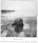 1907
|
1,000 feet (300 m) southwest of the southern end of Oxon Cove Bridge and about 200 feet (61 m) east of the Potomac River | Washington, D.C., and Prince George's County, Maryland | 38°48′13″N 77°01′25″W / 38.803728°N 77.023569°W | Extant | 1996 |
Plaques and Historical Markers
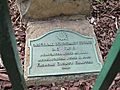
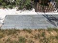
Some boundary markers have special plaques or historical markers nearby. These signs help explain their history.
Plaques
-
 South cornerstone
(2010) -
 Southwest No. 6
(2012) -
 Northeast No. 7 preservation plaque
(2013)
_South_Cornerstone_1926_plaque.jpg)


Historical Markers
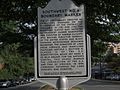
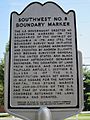
In 2005, Arlington County, Virginia, put up historical markers. These are near the Southwest Nos. 6 and 8 boundary markers.
-
 Southwest No. 6 historical marker
(2012) -
 Southwest No. 8 historical marker
(2012)
_SW_6_Historic_marker.jpg)
_SW_8_Historic_marker.jpg)
Missing Boundary Markers
Four of the original 40 boundary markers were not in their original spots by late 2016. Three of these had been replaced with new markers.
| Name | Image | Description |
|---|---|---|
| Southwest No. 2 |  2013 |
The original Southwest No. 2 marker disappeared before 1900. A new marker is now in a DAR fence at 7 Russell Road in Alexandria. This replacement is about 0.35 miles (0.6 km) southeast of the original spot. The DAR placed it in 1920. This new marker has no carvings and does not look like an original boundary marker. |
| Northeast No. 1 | June 13, 1916 | A photo from 1916 shows a ceremony. DAR members unveiled a fence around Northeast No. 1. The stone was accidentally removed in 1952 during construction. This happened at 7847 Eastern Avenue. A bronze plaque in the sidewalk now marks where the stone used to be. |
| Southeast No. 4 | Southeast No. 4 was described as a "nub" in 1976. It was along Southern Avenue. In 1985, a truck hit the stone. The manager of a nearby building moved it for safekeeping. In 1991, the stone was given to a survey team. A team member kept it in his garage. In 2012, it went to the D.C. Office of the Surveyor. They wanted to put it back. But in 2016, a copy of the stone was placed near the original site. The original stone is now on display at the Office of the Surveyor. | |
| Southeast No. 8 | The original Southeast No. 8 stone was removed in 1958 during construction. It was then lost or stolen. In 1962, the DAR put a new stone in its place. This new stone had no carvings. But later construction buried it. The replacement stone was found almost eight feet underground. It was in the Blue Plains Impoundment Lot. A concrete pipe now marks its spot. In 2015, workers dug up and removed the stone. In early 2016, a new copy of the stone was put in its place. This copy looks like the original when it was new. |
_North_boundary_stone_in_Silver_Spring.jpg)
D.C. Entrance Markers

Other markers were put up later along main roads leading into D.C. These are called the Garden Club of America Entrance Markers. They are also listed on the National Register of Historic Places.
- One pair of markers is in Westmoreland Circle. This is where Western Avenue and Massachusetts Avenue NW meet.
- Two similar markers are on either side of Wisconsin Avenue at Western Avenue. This is in Friendship Heights, near the Metro Station.
- Another pair of markers is in Chevy Chase Circle. This is where Western Avenue and Connecticut Avenue meet.
- A single marker is in a traffic island. This is where Georgia Avenue, Alaska Avenue, and Kalmia Road NW meet.

Another D.C. entrance marker is in a traffic circle (Blair Circle). This is near downtown Silver Spring, Maryland. It is where Eastern Avenue NW, 16th Street NW, N. Portal Drive NW, and Colesville Road meet.
