Dalkey Island facts for kids
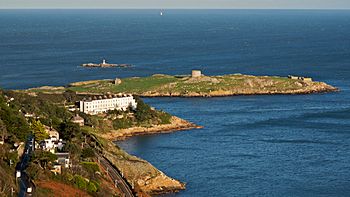
Dalkey Island viewed from Killiney Hill
|
|
| Geography | |
|---|---|
| Location | Irish Sea |
| Coordinates | 53°16′19″N 6°05′03″W / 53.272027°N 6.084132°W |
| Area | 0.09 km2 (0.035 sq mi) |
| Administration | |
| Province | Leinster |
| County | Dublin |
| Demographics | |
| Population | 0 (2011) |
Dalkey Island (pronounced DAW-kee) is a small island near the village of Dalkey in Ireland. Its name, Deilginis, means "thorn island" in Irish. This island is not currently home to any people. It is located about 16 kilometers (10 miles) south of Dublin. It is also about 3 kilometers (2 miles) south of Dún Laoghaire harbour.
For many centuries, Dalkey Island has been an important place for visitors. It has been known as "St Begnet's Isle" for a very long time. The name 'Dalkey Island' first appeared around 1782. In 1841, eight people lived on the island.
Contents
Exploring Dalkey Island
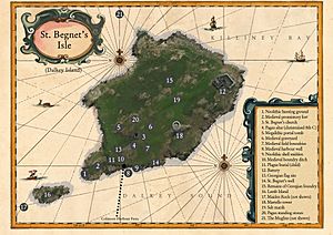
Dalkey Island is not lived on today, but people have lived there for thousands of years. We know this from things left behind from the Stone Age. You can still see old field walls, a church, and a burial mound called a cairn. There is also a gun battery and a Martello tower on the island.
The island has two special wells, called Holy Wells. One on the west side is known as the "Scurvy Well." It is surrounded by a stone structure. There is also a bullaun stone, which is a large rock with a bowl-shaped hollow. This stone might have been used as a pagan altar long ago. In the 7th century, a Christian cross was carved onto it. This stone is near the old church ruins.
At the very north end of the island, you can see signs of a deep ditch. This ditch was part of an old fort from the Middle Ages. The island is less than 300 meters (980 feet) from the mainland. It covers about 9 hectares (22 acres). You can visit the island by boat from Bulloch Harbour. During the summer, a regular ferry also runs from Coliemore Harbour. Coliemore Harbour means 'Big Harbour' in Irish.
A Journey Through Time on Dalkey Island
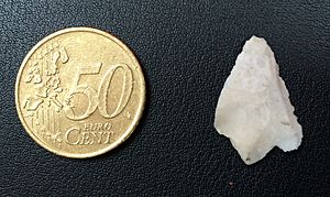
Dalkey Island is only a 5-minute boat ride from Coliemore Harbour. It is full of very old and important historical sites. Things found on the island are now kept in the National Museum of Ireland in Dublin. These items show that the first people on the island lived there during the Middle Stone Age. People continued to use the island through the later Stone Age, the Iron Age, and the early Christian period.
Ancient Life and Viking Visitors
Evidence shows people lived on Dalkey Island 6,000 years ago. It was also used as a base by the Vikings. Archaeologists have found old pottery and glass from the early Middle Ages on the island. Some of these items came from places like Turkey or Greece.
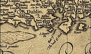
Dalkey Island was a very important place for religious journeys in the Middle Ages. This is why it appears clearly on old maps. For example, Danti's map of 'Isole Britaniche' from around 1560 shows the island. People believed that drinking water from the well named after St Begnet could cure scurvy. Recent tests show the water has a lot of vitamin C, which helps cure scurvy. This is probably because the well is located below a salt marsh.
The Church of St Begnet
The ruins of a church from the 7th century are on the island. This church is named after St Begnet. It is thought that an older wooden church was there before the stone one was built. Another church in Dalkey village is also named after St Begnet. This might have been a starting point for people before they crossed to the island. Pilgrims would buy special badges in the town. These badges would be sewn into their burial clothes to show they had made the journey. This was believed to help them get into heaven.
In 1539, King Henry VIII ordered the church on St Begnet's Island to be raided. This was part of his plan to close down monasteries. The church's valuable items were taken and sold for the king.
Later History and Defenses
The town of Dalkey was once called Kilbegnet in early Christian times. The name 'Dalkey Island' first appeared on a map around 1782. This was when the island started to be used by the British military. The church on the island was changed in the early 1800s. Builders used it as a place to live while they built the nearby Martello Tower and gun battery in 1804.
Archaeologists dug up parts of the island in the late 1960s. They found evidence of a churchyard and many burials. Most of the skeletons were male, which fits with the idea that it was an early Christian monastery.
A promontory fort was built at the north end of the island. This fort helped protect Coliemore Harbour, which was the main deep-water port for Dublin in the Middle Ages. You can still see the remains of a ditch from this fort today.
Viking Raids and Martello Towers
The ruined stone church might be as old as the 7th century. It was probably left empty for a while when the Vikings used the island as a base. The Annals of the Four Masters say that in 938, an abbot named Coibhdeanagh drowned near the island. He was trying to escape a Viking raid with treasures from the church hidden in his clothes.
In the early 1800s, the British Admiralty built the Martello Tower on the island. This tower was one of eight along the Dún Laoghaire coastline. They were built as an early warning system to defend against a possible invasion during the Napoleonic Wars.
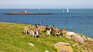
A group of goats lives on the island today. They were first brought there in the early 1800s. The original goats were removed, but new ones were brought in to replace them.
Waters and Fun Activities
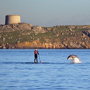
Dalkey Island is a great place for fishing. You can catch fish like pollock, coalfish, wrasse, and mackerel there. The water channel between the island and the mainland is very deep.
The waters around Dalkey Island are popular for sailing, fishing, and diving. There are also rocks nearby called Maiden or Carraig Rock, Clare Rock, and Lamb Island. These rocks are part of the island's ridge. Some parts of these rocks can only be seen when the tide is low. The southern end of the island is a favorite spot for kayakers, especially when the tide is coming in. The water here can be very strong, and it can be challenging for kayakers if there is a strong southeast wind. When kayaking around the island on a rising tide, it is easier to go in an anti-clockwise direction.
Wildlife on Dalkey Island
Dalkey Island is home to a large group of seals, which has grown a lot recently. Rabbits and a group of wild goats also live on the island. Birdwatch Ireland has helped create a home for Roseate Terns on Maiden Rock, just north of the island. Ireland has most of Europe's population of these special birds.
The Muglins
To the east of Dalkey Island are some rocks called "The Muglins." These rocks are a separate group. They are dangerous for ships, so a special beacon has been placed there. The beacon stands where a 'gibbet' once was. This was a place where the bodies of two men, Peter McKinlie and George Gidley, were displayed after they were executed in 1765. They were found guilty of killing Captain Cockeran, Captain George Glas, and his family, and others on a ship called the Earl of Sandwich. Their remains are now buried under the concrete base of the beacon.
Images for kids
See also
 In Spanish: Isla Dalkey para niños
 | William L. Dawson |
 | W. E. B. Du Bois |
 | Harry Belafonte |


