DeSoto County, Florida facts for kids
Quick facts for kids
DeSoto County
|
||
|---|---|---|

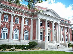
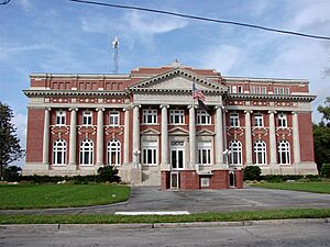
DeSoto County Courthouse
|
||
|
||

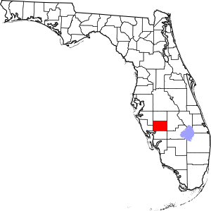
Location within the U.S. state of Florida
|
||
 Florida's location within the U.S. |
||
| Country | ||
| State | ||
| Founded | May 19, 1887 | |
| Named for | Hernando de Soto | |
| Seat | Arcadia | |
| Largest city | Arcadia | |
| Area | ||
| • Total | 639 sq mi (1,660 km2) | |
| • Land | 637 sq mi (1,650 km2) | |
| • Water | 2.4 sq mi (6 km2) 0.4%% | |
| Population
(2020)
|
||
| • Total | 33,976 | |
| • Estimate
(2023)
|
35,979 |
|
| • Density | 53.17/sq mi (20.529/km2) | |
| Time zone | UTC−5 (Eastern) | |
| • Summer (DST) | UTC−4 (EDT) | |
| Congressional district | 18th | |
DeSoto County is a county located in the Florida Heartland region of the U.S. state of Florida. As of the 2020 census, about 33,976 people lived here. Its main town and county seat is Arcadia. DeSoto County is part of a larger area that includes North Port, Bradenton, and Sarasota.
Contents
History of DeSoto County
Before the Spanish arrived, the Native American Calusa tribe lived in the area that is now DeSoto County.
Early Explorers
In 1513, explorer Ponce De Leon sailed into what is now Charlotte Harbor. He met the Calusa people there. Later, in 1521, he tried to start a colony nearby but was turned away by the Calusa.
In 1528, Spanish explorers Panfilo De Narvaez and Cabeza De Vaca came to the area. They met Calusa people who told them about gold to the north.
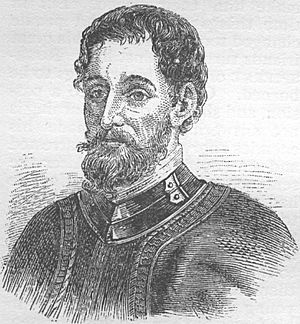
In 1539, the Spanish explorer Hernando de Soto arrived. DeSoto County is named after him. He explored the region, eventually moving north from Charlotte Harbor.
Becoming Part of the U.S.
Florida was claimed by Spain in 1565. This included what is now DeSoto County. Later, in 1763, the area became part of East Florida under British rule. In 1783, it went back to Spain. Finally, in 1821, it became part of the United States.
In 1841, Camp Ogden (later Fort Ogden) was built. It was a base for the U.S. Army during the Second Seminole War.
County Formation and Changes
DeSoto County was created in 1887 from Manatee County. It was named after Hernando de Soto.
Originally, DeSoto County was much larger. In 1921, the Florida government created several new counties from its land. These included Charlotte, Glades, Hardee, and Highlands counties.
World War II and Hurricane Charley
During World War II, DeSoto County had the Carlstrom Field Air Base. This base trained American and British pilots. After the war, the base was closed. It later became a mental health facility and then a center for young offenders.
On August 13, 2004, Hurricane Charley hit DeSoto County directly. The strong winds caused a lot of damage to buildings in the county.
Geography of DeSoto County
DeSoto County covers about 639 square miles. Most of this is land, with a small amount of water. The highest point in the county is 96 feet high. The lowest point is sea level, found in the Peace River.
Neighboring Counties
DeSoto County shares borders with these counties:
- Hardee County, Florida - to the north
- Highlands County, Florida - to the east
- Glades County, Florida - to the southeast
- Charlotte County, Florida - to the south
- Sarasota County, Florida - to the west
- Manatee County, Florida - to the northwest
Lakes and Rivers
The largest natural lake in DeSoto County is Sour Orange Lake. There are also a few other small lakes and ponds. The most important river is the Peace River.
People of DeSoto County (Demographics)
| Historical population | |||
|---|---|---|---|
| Census | Pop. | %± | |
| 1890 | 4,944 | — | |
| 1900 | 8,047 | 62.8% | |
| 1910 | 14,200 | 76.5% | |
| 1920 | 25,434 | 79.1% | |
| 1930 | 7,745 | −69.5% | |
| 1940 | 7,792 | 0.6% | |
| 1950 | 9,242 | 18.6% | |
| 1960 | 11,683 | 26.4% | |
| 1970 | 13,060 | 11.8% | |
| 1980 | 19,039 | 45.8% | |
| 1990 | 23,865 | 25.3% | |
| 2000 | 32,209 | 35.0% | |
| 2010 | 34,862 | 8.2% | |
| 2020 | 33,976 | −2.5% | |
| 2023 (est.) | 35,979 | 3.2% | |
| U.S. Decennial Census 1790–1960 1900–1990 1990–2000 2010–2019 |
|||
In 2020, DeSoto County had 33,976 people living in 12,421 households.
| Race | Number of People | Percentage |
|---|---|---|
| White (not Hispanic) | 18,624 | 54.82% |
| Black or African American (not Hispanic) | 4,203 | 12.37% |
| Native American or Alaska Native (not Hispanic) | 80 | 0.24% |
| Asian (not Hispanic) | 189 | 0.56% |
| Pacific Islander (not Hispanic) | 8 | 0.02% |
| Other Race (not Hispanic) | 80 | 0.24% |
| Mixed/Multi-Racial (not Hispanic) | 781 | 2.3% |
| Hispanic or Latino (any race) | 10,011 | 29.46% |
| Total | 33,976 |
In 2000, the average household had 2.70 people. About 22.70% of the population was under 18 years old. The median age was 36 years.
Library Services
DeSoto County is part of the Heartland Library Cooperative. This library system serves DeSoto and several nearby counties. There is one library branch in Arcadia.
Local Media
Newspaper
The Charlotte Sun newspaper has a special section for DeSoto County called "The Arcadian."
Television
DeSoto County is in the Fort Myers/Naples TV market. Most TV stations from Fort Myers and Naples can be received here. Some stations from the Tampa/St. Petersburg/Sarasota area can also be received.
Radio
DeSoto County has two local radio stations:
- WCXS (1480 AM Classic Country music)
- WZSP (105.3 FM La Zeta - Mexican music)
Communities in DeSoto County

City
Census-designated place (CDP)
Unincorporated communities
These are places that are not officially cities or towns:
- Brownville
- Fort Ogden
- Hidden Acres
- Hull
- Lake Suzy
- Nocatee
Ghost towns
These are towns that no longer exist:
Transportation
Airports
Arcadia Municipal Airport is the only public airport in DeSoto County.
Major Highways
 Interstate 75 runs through a small part of the county.
 U.S. Route 17
 State Road 31
 State Road 70
 State Road 72
See also
 In Spanish: Condado de DeSoto (Florida) para niños
 | Lonnie Johnson |
 | Granville Woods |
 | Lewis Howard Latimer |
 | James West |


