DeValls Bluff, Arkansas facts for kids
Quick facts for kids
DeValls Bluff, Arkansas
|
|
|---|---|

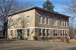
Prairie County Courthouse, Southern District
|
|

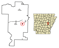
Location of De Valls Bluff in Prairie County, Arkansas.
|
|
| Country | United States |
| State | Arkansas |
| County | Prairie |
| Incorporated | April 4, 1866 |
| Area | |
| • Total | 1.16 sq mi (3.00 km2) |
| • Land | 1.09 sq mi (2.83 km2) |
| • Water | 0.07 sq mi (0.17 km2) |
| Elevation | 190 ft (58 m) |
| Population
(2020)
|
|
| • Total | 520 |
| • Density | 476.19/sq mi (183.83/km2) |
| Time zone | UTC-6 (Central (CST)) |
| • Summer (DST) | UTC-5 (CDT) |
| ZIP code |
72041
|
| Area code(s) | 870 |
| FIPS code | 05-18640 |
| GNIS feature ID | 0076762 |
DeValls Bluff is a small city in Prairie County, Arkansas, USA. It's one of the two main towns in the county. In 2020, about 520 people lived there.
Contents
A Look Back at DeValls Bluff
Prairie County has always been important for moving people and goods in Arkansas. Long ago, the White River was the main way to travel and ship things. This was before railroads were built.
Prairie County was formed in 1846 from parts of other counties. The first known settlers in the DeValls Bluff area were Jacob M. DeVall and his son, Chappel, around 1851.
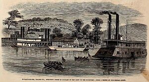
During the Civil War, DeValls Bluff was a busy trading spot on the White River. It was also important because a railroad connected it to North Little Rock.
Union soldiers captured DeValls Bluff in January 1863. But they later left, and the town went back to Confederate control. Later, in August 1863, Union forces captured it again. DeValls Bluff then became a place to store supplies and care for injured Union soldiers for the rest of the war.
Where DeValls Bluff Is Located
DeValls Bluff is located at 34°47′5″N 91°27′37″W / 34.78472°N 91.46028°W. The city is in a flat, open area called the Grand Prairie. This area is part of a larger region known as the Mississippi Alluvial Plain.
The Grand Prairie used to be a big grassland. Early settlers cleared much of it for farming. Today, the area is known for growing rice, raising fish (aquaculture), and duck hunting.
The city covers about 2.8 square kilometers (1.1 square miles). Most of this is land, with a small part being water.
How Many People Live Here?
| Historical population | |||
|---|---|---|---|
| Census | Pop. | %± | |
| 1880 | 186 | — | |
| 1890 | 380 | 104.3% | |
| 1900 | 605 | 59.2% | |
| 1910 | 924 | 52.7% | |
| 1920 | 885 | −4.2% | |
| 1930 | 672 | −24.1% | |
| 1940 | 686 | 2.1% | |
| 1950 | 830 | 21.0% | |
| 1960 | 654 | −21.2% | |
| 1970 | 622 | −4.9% | |
| 1980 | 738 | 18.6% | |
| 1990 | 702 | −4.9% | |
| 2000 | 783 | 11.5% | |
| 2010 | 619 | −20.9% | |
| 2020 | 520 | −16.0% | |
| Encyclopedia of Arkansas History and Culture |
|||
The number of people living in DeValls Bluff has changed over the years. In 2000, there were 783 people living in the town. By 2020, the population was 520.
The population includes people of different ages. In 2000, about 28.6% of the people were under 18 years old. About 18.1% were 65 years or older. The average age in the town was 38 years.
Schools in the Area
Students in DeValls Bluff attend schools in the Hazen School District. The high school for the area is Hazen High School.
The DeValls Bluff School District used to be separate. But on July 1, 2006, it joined with the Hazen district.
See also
 In Spanish: De Valls Bluff (Arkansas) para niños


